
Magnitude |
:2.8 |
| Date & Time (UTC) | 2012-07-01 22:49:04.3 |
| Date & Time (Local) | 1391/4/12 03:19:04.3 |
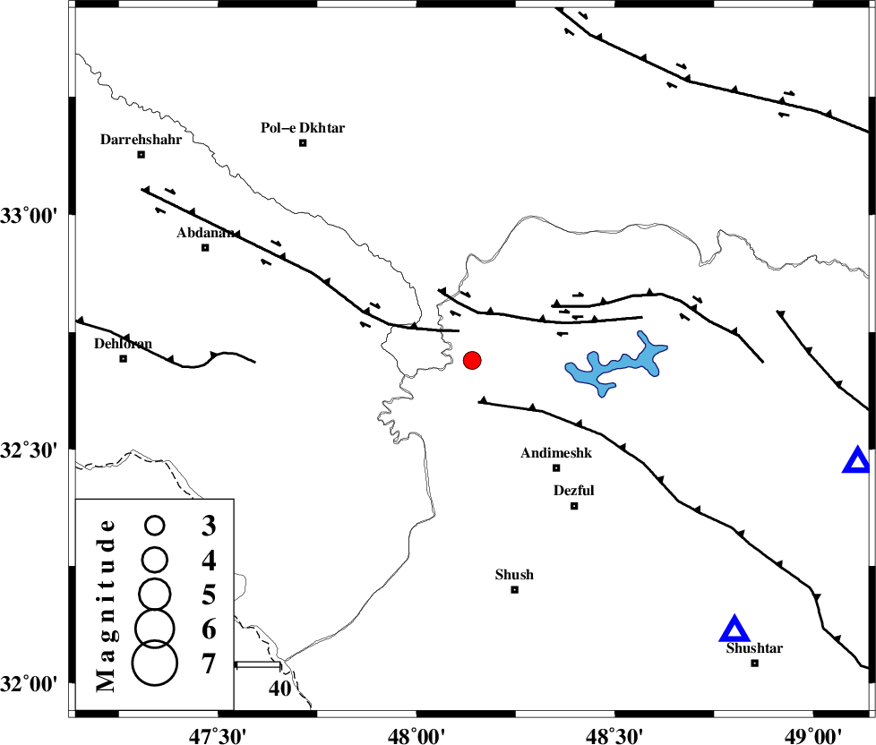
| Location | Lat:32.69 Lon: 48.14 |
| Region | Khoozestan Province, 32 km North-West of Andimeshk |
Nearest Cities |
|
| 10 km North West of Hoseinieh, Khoozestan Province | |
| 12 km of Bidruyeh, Khoozestan Province | |
| 20 km West of Sorkhakan, Khoozestan Province | |
| 32 km North West of Andimeshk, Khoozestan Province | |
| 42 km North West of Dezful, Khoozestan Province | |
| Depth | 14 km |
| Agency | |
Faults within 150 km: |
|
| BALARUD_F_Z1 (Length: 87 km) , Distance to epicenter: 8 km | |
| DEZFUL_EMBAYMENT (Length: 228 km) , Distance to epicenter: 10 km | |
| BALARUD_F_Z3 (Length: 53 km) , Distance to epicenter: 11 km | |
| Number of Phases | 5 |
| RMS | 0.1 |
| Number of Stations | 4 |
| Error in Latitude | >2.7 km |
| Error in Longitude | 7.2 km |
| Error in Depth | 5.8 km |
Download waveform in seisan format
to download seisan software Click here
to access information about IIEES stations Click here
Amplitude | ||||||||
| UID | Agency | Station | Component | Amplitude | Period | Arrival Time | Proccessing Time | Signal Clip |
| 84338 | IIEES | SHGR | N | 373.2 | 0.4 | 2012-07-01 22:49:42 | 2012-07-01 11:00:00 | n |
| 84339 | IIEES | SHGR | E | 399.4 | 0.52 | 2012-07-01 22:49:45 | 2012-07-01 11:00:00 | n |
| 84340 | IIEES | KHMZ | E | 72.5 | 0.68 | 2012-07-01 22:50:07 | 2012-07-01 11:00:00 | n |
| 84341 | IIEES | KHMZ | N | 83.9 | 0.68 | 2012-07-01 22:50:08 | 2012-07-01 11:00:00 | n |
| 84342 | IIEES | ASAO | E | 35.8 | 0.4 | 2012-07-01 22:50:29 | 2012-07-01 11:00:00 | n |
| 84343 | IIEES | GHVR | N | 21.8 | 0.48 | 2012-07-01 22:50:39 | 2012-07-01 11:00:00 | n |
| 84344 | IIEES | GHVR | E | 26.7 | 0.32 | 2012-07-01 22:50:39 | 2012-07-01 11:00:00 | n |
Phase | ||||||||||||
| Agency | Station | Component | Phase Type | Phase Quality | First Motion | Observed Arrival Time | Time Residual | Loc. Flag | Input Weight | Distance | Azimuth | |
| IIEES | SHGR | Z | Pg | E | 2012-07-01 22:49:19 | 0.02 | y | 89.8 | 136 | |||
| IIEES | KHMZ | Z | Pg | E | 2012-07-01 22:49:38 | -0.04 | y | 206 | 55 | |||
| IIEES | KHMZ | E | Sg | E | 2012-07-01 22:50:03 | 0.02 | y | 206 | 55 | |||
| IIEES | ASAO | Z | Pn | E | 2012-07-01 22:49:45 | 0.08 | y | 271 | 40 | |||
| IIEES | GHVR | Z | Pn | E | 2012-07-01 22:49:55 | -0.09 | y | 350 | 55 | |||