
Magnitude |
:3.9 |
| Date & Time (UTC) | 2012-07-01 22:18:16.2 |
| Date & Time (Local) | 1391/4/12 02:48:16.2 |
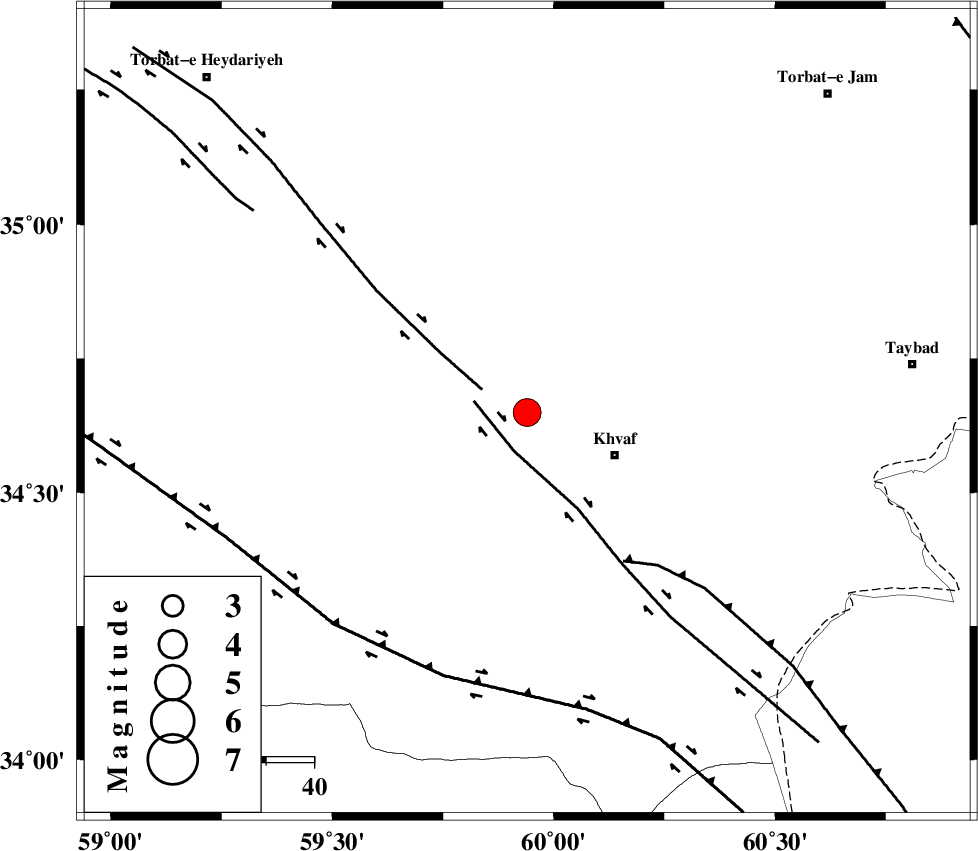
| Location | Lat:34.65 Lon: 59.94 |
| Region | Khorasan(center) Province, 20 km West of Khaf |
Nearest Cities |
|
| 11 km of Salami, Khorasan(center) Province | |
| 20 km North West of Khaf, Khorasan(center) Province | |
| 23 km South East of Chamanabad, Khorasan(center) Province | |
| 26 km North West of Kharkord, Khorasan(center) Province | |
| 32 km North of Qasemabad, Khorasan(center) Province | |
| Depth | 15 km |
| Agency | |
Faults within 150 km: |
|
| KHAF_F (Length: 58 km) , Distance to epicenter: 6 km | |
| JANGAL_F (Length: 111 km) , Distance to epicenter: 17 km | |
| DORUNEH_F (Length: 713 km) , Distance to epicenter: 32 km | |
| Number of Phases | 7 |
| RMS | 0 |
| Number of Stations | 5 |
| Error in Latitude | >1.7 km |
| Error in Longitude | 1.8 km |
| Error in Depth | 2.7 km |
Download waveform in seisan format
to download seisan software Click here
to access information about IIEES stations Click here
Amplitude | ||||||||
| UID | Agency | Station | Component | Amplitude | Period | Arrival Time | Proccessing Time | Signal Clip |
| 84328 | IIEES | SHRT | E | 3372.6 | 0.28 | 2012-07-01 22:18:51 | 2012-07-01 10:39:00 | n |
| 84329 | IIEES | SHRT | N | 4053.7 | 0.36 | 2012-07-01 22:18:51 | 2012-07-01 10:39:00 | n |
| 84330 | IIEES | TABS | N | 427.4 | 0.36 | 2012-07-01 22:19:39 | 2012-07-01 10:39:00 | n |
| 84331 | IIEES | GHVR | N | 10.6 | 0.68 | 2012-07-01 22:22:29 | 2012-07-01 10:39:00 | n |
| 84332 | IIEES | GHVR | E | 14.9 | 0.6 | 2012-07-01 22:22:32 | 2012-07-01 10:39:00 | n |
Phase | ||||||||||||
| Agency | Station | Component | Phase Type | Phase Quality | First Motion | Observed Arrival Time | Time Residual | Loc. Flag | Input Weight | Distance | Azimuth | |
| IIEES | SHRT | Z | Pg | E | 2012-07-01 22:18:35 | -0.02 | y | 115 | 164 | |||
| IIEES | TABS | Z | Pn | E | 2012-07-01 22:18:58 | -0.05 | y | 283 | 248 | |||
| IIEES | TABS | E | Sg | E | 2012-07-01 22:19:35 | 0.01 | y | 283 | 248 | |||
| IIEES | SHRO | Z | Pn | E | 2012-07-01 22:19:12 | 0.01 | y | 388 | 294 | |||
| IIEES | SHRO | E | Sg | E | 2012-07-01 22:20:04 | 0 | y | 388 | 294 | |||
| IIEES | ZHSF | Z | Pn | E | 2012-07-01 22:19:34 | 0.06 | y | 564 | 172 | |||
| IIEES | GHVR | Z | Pn | E | 2012-07-01 22:20:02 | 0 | y | 798 | 271 | |||