
Magnitude |
:4.7 |
| Date & Time (UTC) | 2012-07-01 02:49:48.5 |
| Date & Time (Local) | 1391/4/11 07:19:48.5 |
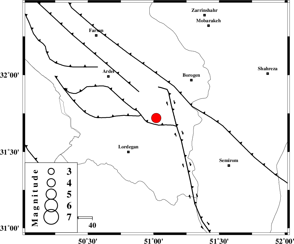
| Location | Lat:31.72 Lon: 51.02 |
| Region | Chaharmahal Bakhtiari Province, 31 km North-East of Lordegan |
Nearest Cities |
|
| 19 km North of Aluni, Chaharmahal Bakhtiari Province | |
| 21 km South West of Gandoman, Chaharmahal Bakhtiari Province | |
| 23 km South of Baladaji, Chaharmahal Bakhtiari Province | |
| 24 km North East of Armand-e olia, Chaharmahal Bakhtiari Province | |
| 32 km North East of Lordegan, Chaharmahal Bakhtiari Province | |
| Depth | 14 km |
| Agency | |
Faults within 150 km: |
|
| DOPOLAN_F (Length: 107 km) , Distance to epicenter: 5 km | |
| SABZKUH_F (Length: 67 km) , Distance to epicenter: 11 km | |
| DENA_F (Length: 137 km) , Distance to epicenter: 15 km | |
| Number of Phases | 7 |
| RMS | 0.1 |
| Number of Stations | 6 |
| Error in Latitude | >2 km |
| Error in Longitude | 2.4 km |
| Error in Depth | 5.7 km |
Download waveform in seisan format
to download seisan software Click here
to access information about IIEES stations Click here
Amplitude | ||||||||
| UID | Agency | Station | Component | Amplitude | Period | Arrival Time | Proccessing Time | Signal Clip |
| 84315 | IIEES | NASN | N | 4011.9 | 0.6 | 2012-07-01 02:50:58 | 2012-07-01 03:03:00 | n |
| 84316 | IIEES | SHGR | N | 7269.6 | 0.64 | 2012-07-01 02:50:55 | 2012-07-01 03:03:00 | n |
| 84317 | IIEES | SHGR | E | 10253.9 | 0.6 | 2012-07-01 02:51:07 | 2012-07-01 03:03:00 | n |
| 84318 | IIEES | KHMZ | E | 4439.9 | 0.56 | 2012-07-01 02:51:01 | 2012-07-01 03:03:00 | n |
| 84319 | IIEES | KHMZ | N | 2817.1 | 0.56 | 2012-07-01 02:51:06 | 2012-07-01 03:03:00 | n |
Phase | ||||||||||||
| Agency | Station | Component | Phase Type | Phase Quality | First Motion | Observed Arrival Time | Time Residual | Loc. Flag | Input Weight | Distance | Azimuth | |
| IIEES | NASN | Z | Pn | E | 2012-07-01 02:50:22 | -0.02 | y | 207 | 54 | |||
| IIEES | SHGR | Z | P | E | 2012-07-01 02:50:22 | 0.02 | y | 214 | 282 | |||
| IIEES | KHMZ | Z | Pn | E | 2012-07-01 02:50:26 | 0.12 | y | 245 | 337 | |||
| IIEES | KHMZ | E | Sg | E | 2012-07-01 02:50:57 | -0.12 | y | 245 | 337 | |||
| IIEES | GHVR | Z | Pn | E | 2012-07-01 02:50:34 | 0.13 | y | 307 | 4 | |||
| IIEES | GHIR | Z | Pn | E | 2012-07-01 02:50:48 | -0.1 | y | 425 | 153 | |||
| IIEES | THKV | Z | Pn | E | 2012-07-01 02:50:54 | -0.06 | y | 466 | 358 | |||