
Magnitude |
:3 |
| Date & Time (UTC) | 2012-06-30 14:35:59.2 |
| Date & Time (Local) | 1391/4/10 19:05:59.2 |
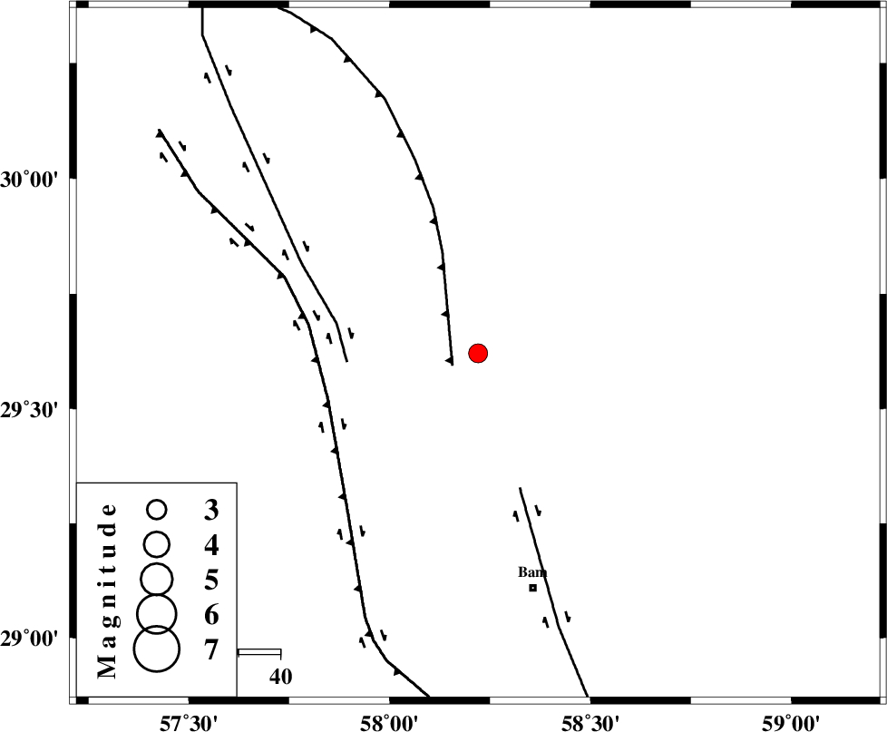
| Location | Lat:29.62 Lon: 58.22 |
| Region | Kerman Province, 59 km North-West of Bam |
Nearest Cities |
|
| 27 km South of Geshit, Kerman Province | |
| 51 km South East of Golbaft, Kerman Province | |
| 57 km North West of Poshtrud, Kerman Province | |
| 58 km North West of Bam, Kerman Province | |
| 66 km North West of Baravat, Kerman Province | |
| Depth | 14 km |
| Agency | |
Faults within 150 km: |
|
| SHAHDAD_F (Length: 108 km) , Distance to epicenter: 7 km | |
| GOLBAF_SIRCH_F (Length: 114 km) , Distance to epicenter: 32 km | |
| BAM_F (Length: 118 km) , Distance to epicenter: 34 km | |
| Number of Phases | 5 |
| RMS | 0.1 |
| Number of Stations | 3 |
| Error in Latitude | >4.1 km |
| Error in Longitude | 0.9 km |
| Error in Depth | 4.6 km |
Download waveform in seisan format
to download seisan software Click here
to access information about IIEES stations Click here
Amplitude | ||||||||
| UID | Agency | Station | Component | Amplitude | Period | Arrival Time | Proccessing Time | Signal Clip |
| 84308 | IIEES | KRBR | E | 251.6 | 0.12 | 2012-06-30 14:36:44 | 2012-06-30 03:35:00 | n |
| 84309 | IIEES | KRBR | N | 244.1 | 0.44 | 2012-06-30 14:36:45 | 2012-06-30 03:35:00 | n |
Phase | ||||||||||||
| Agency | Station | Component | Phase Type | Phase Quality | First Motion | Observed Arrival Time | Time Residual | Loc. Flag | Input Weight | Distance | Azimuth | |
| IIEES | KRBR | Z | Pg | E | 2012-06-30 14:36:23 | -0.04 | y | 147 | 286 | |||
| IIEES | KRBR | N | Sg | E | 2012-06-30 14:36:41 | 0.02 | y | 147 | 286 | |||
| IIEES | ZHSF | Z | Pn | E | 2012-06-30 14:36:37 | 0.09 | y | 247 | 90 | |||
| IIEES | ZHSF | N | Sg | E | 2012-06-30 14:37:09 | -0.05 | y | 247 | 90 | |||
| IIEES | BNDS | Z | Pn | E | 2012-06-30 14:36:46 | -0.01 | y | 318 | 220 | |||