
Magnitude |
:3.3 |
| Date & Time (UTC) | 2012-06-29 20:18:02.8 |
| Date & Time (Local) | 1391/4/10 00:48:02.8 |
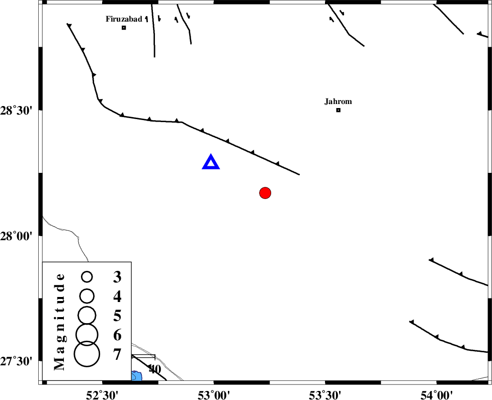
| Location | Lat:28.17 Lon: 53.23 |
| Region | Fars Province, 38 km South-East of Qir va Karzin |
Nearest Cities |
|
| 8 km North of Seyfabad, Fars Province | |
| 24 km South of Mobarakabad, Fars Province | |
| 31 km South East of Shahrak-e jonubi, Fars Province | |
| 36 km South West of Hasanabad, Fars Province | |
| 36 km South of Fathabad, Fars Province | |
| Depth | 43 km |
| Agency | |
Faults within 150 km: |
|
| QIR_F (Length: 130 km) , Distance to epicenter: 17 km | |
| SABZ_PUSHAN_F_Z2 (Length: 24 km) , Distance to epicenter: 73 km | |
| SABZ_PUSHAN_F_Z1 (Length: 69 km) , Distance to epicenter: 77 km | |
| Number of Phases | 6 |
| RMS | 0.5 |
| Number of Stations | 4 |
| Error in Latitude | >7.4 km |
| Error in Longitude | 3.9 km |
| Error in Depth | 5.7 km |
Download waveform in seisan format
to download seisan software Click here
to access information about IIEES stations Click here
Amplitude | ||||||||
| UID | Agency | Station | Component | Amplitude | Period | Arrival Time | Proccessing Time | Signal Clip |
| 84299 | IIEES | BNDS | N | 163.5 | 0.4 | 2012-06-29 20:19:32 | 2012-06-29 09:43:00 | n |
| 84300 | IIEES | BNDS | E | 181.8 | 0.68 | 2012-06-29 20:19:33 | 2012-06-29 09:43:00 | n |
| 84301 | IIEES | KRBR | N | 45.5 | 0.56 | 2012-06-29 20:20:18 | 2012-06-29 09:43:00 | n |
| 84302 | IIEES | KRBR | E | 34.7 | 0.68 | 2012-06-29 20:20:26 | 2012-06-29 09:43:00 | n |
Phase | ||||||||||||
| Agency | Station | Component | Phase Type | Phase Quality | First Motion | Observed Arrival Time | Time Residual | Loc. Flag | Input Weight | Distance | Azimuth | |
| IIEES | GHIR | Z | Pg | E | 2012-06-29 20:18:11 | 0.28 | y | 26.5 | 298 | |||
| IIEES | AHRM | Z | Pn | E | 2012-06-29 20:18:32 | -0.55 | y | 204 | 293 | |||
| IIEES | BNDS | Z | Pn | E | 2012-06-29 20:18:45 | 0.17 | y | 303 | 106 | |||
| IIEES | BNDS | E | Sg | E | 2012-06-29 20:19:26 | -0.28 | y | 303 | 106 | |||
| IIEES | KRBR | Z | Pn | E | 2012-06-29 20:18:58 | 0.82 | y | 398 | 59 | |||
| IIEES | KRBR | E | Sg | E | 2012-06-29 20:19:51 | -0.36 | y | 398 | 59 | |||