
Magnitude |
:2.9 |
| Date & Time (UTC) | 2012-06-25 22:29:48.6 |
| Date & Time (Local) | 1391/4/6 02:59:48.6 |
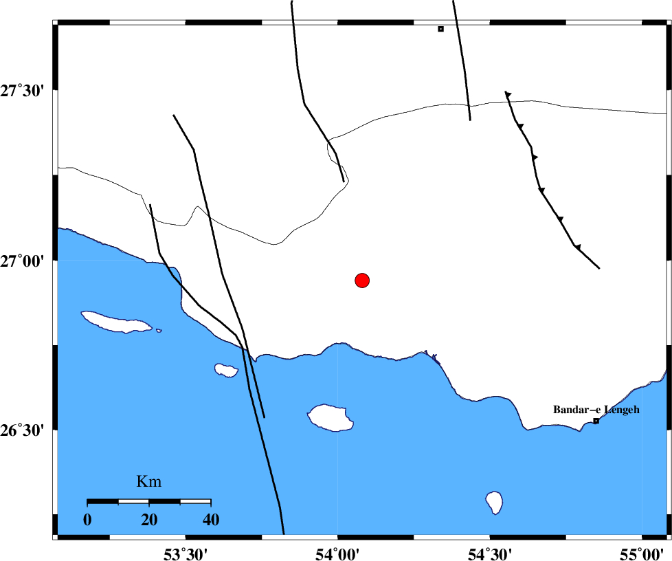
| Location | Lat:26.94 Lon: 54.08 |
| Region | Hormozgan Province, 40 km South-West of Bastak |
Nearest Cities |
|
| 22 km West of Jenah, Hormozgan Province | |
| 40 km South West of Bastak, Hormozgan Province | |
| 43 km South East of Ahl, Fars Province | |
| 56 km South East of Ashkenan, Fars Province | |
| 62 km South of Bagh, Fars Province | |
| Depth | 38 km |
| Agency | |
Faults within 150 km: |
|
| MFF3 (Length: 292 km) , Distance to epicenter: 5 km | |
| MFF1 (Length: 180 km) , Distance to epicenter: 13 km | |
| ZFF1 (Length: 165 km) , Distance to epicenter: 22 km | |
| Number of Phases | 5 |
| RMS | 0.1 |
| Number of Stations | 3 |
| Error in Latitude | >3.3 km |
| Error in Longitude | 3.2 km |
| Error in Depth | 4.8 km |
Download waveform in seisan format
to download seisan software Click here
to access information about IIEES stations Click here
Amplitude | ||||||||
| UID | Agency | Station | Component | Amplitude | Period | Arrival Time | Proccessing Time | Signal Clip |
| 84246 | IIEES | GHIR | N | 108.4 | 0.52 | 2012-06-25 22:30:48 | 2012-06-25 11:48:00 | n |
| 84247 | IIEES | GHIR | E | 119.3 | 0.64 | 2012-06-25 22:30:52 | 2012-06-25 11:48:00 | n |
| 84248 | IIEES | BNDS | E | 129.9 | 0.4 | 2012-06-25 22:30:56 | 2012-06-25 11:48:00 | n |
| 84249 | IIEES | BNDS | N | 110.3 | 0.44 | 2012-06-25 22:31:04 | 2012-06-25 11:48:00 | n |
Phase | ||||||||||||
| Agency | Station | Component | Phase Type | Phase Quality | First Motion | Observed Arrival Time | Time Residual | Loc. Flag | Input Weight | Distance | Azimuth | |
| IIEES | GHIR | Z | Pn | E | 2012-06-25 22:30:17 | -0.01 | y | 183 | 324 | |||
| IIEES | GHIR | E | Sg | E | 2012-06-25 22:30:40 | -0.02 | y | 183 | 324 | |||
| IIEES | BNDS | Z | Pn | E | 2012-06-25 22:30:20 | -0.08 | y | 214 | 76 | |||
| IIEES | KRBR | N | Pn | E | 2012-06-25 22:30:47 | 0.19 | y | 427 | 37 | |||
| IIEES | KRBR | E | Sn | 2012-06-25 22:31:30 | -0.05 | y | 427 | 37 | ||||