
Magnitude |
:3.2 |
| Date & Time (UTC) | 2012-06-21 01:03:17.9 |
| Date & Time (Local) | 1391/4/1 05:33:17.9 |
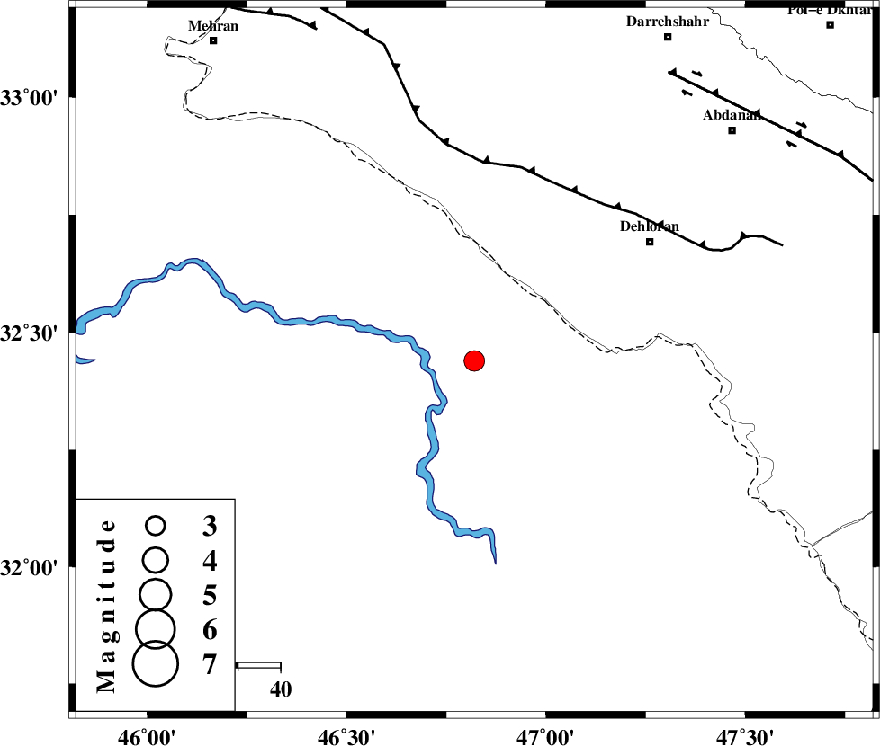
| Location | Lat:32.44 Lon: 46.82 |
| Region | Iraq, 50 km South-West of Dehloran |
Nearest Cities |
|
| 45 km South West of Bishehzar, Ilam Province | |
| 50 km South West of Dehloran, Ilam Province | |
| 52 km South West of Musian, Ilam Province | |
| 82 km South West of Abdanan, Ilam Province | |
| 86 km South West of Sarabbagh, Ilam Province | |
| Depth | 18 km |
| Agency | |
Faults within 150 km: |
|
| MFF6 (Length: 144 km) , Distance to epicenter: 46 km | |
| BALARUD_F_Z1 (Length: 87 km) , Distance to epicenter: 82 km | |
| ZFF4 (Length: 128 km) , Distance to epicenter: 87 km | |
| Number of Phases | 7 |
| RMS | 0.1 |
| Number of Stations | 5 |
| Error in Latitude | >3.4 km |
| Error in Longitude | 8.5 km |
| Error in Depth | 10.9 km |
Download waveform in seisan format
to download seisan software Click here
to access information about IIEES stations Click here
Amplitude | ||||||||
| UID | Agency | Station | Component | Amplitude | Period | Arrival Time | Proccessing Time | Signal Clip |
| 84205 | IIEES | SHGR | N | 1501.3 | 0.76 | 2012-06-21 01:04:16 | 2012-06-21 01:43:00 | n |
| 84206 | IIEES | KHMZ | Z | 37.3 | 0.64 | 2012-06-21 01:04:57 | 2012-06-21 01:43:00 | n |
| 84207 | IIEES | KHMZ | N | 45.4 | 0.6 | 2012-06-21 01:05:00 | 2012-06-21 01:43:00 | n |
| 84208 | IIEES | GHVR | E | 29.4 | 0.52 | 2012-06-21 01:05:15 | 2012-06-21 01:43:00 | n |
| 84209 | IIEES | GHVR | N | 22 | 0.76 | 2012-06-21 01:05:43 | 2012-06-21 01:43:00 | n |
Phase | ||||||||||||
| Agency | Station | Component | Phase Type | Phase Quality | First Motion | Observed Arrival Time | Time Residual | Loc. Flag | Input Weight | Distance | Azimuth | |
| IIEES | SHGR | Z | Pn | E | 2012-06-21 01:03:48 | 0.08 | y | 191 | 101 | |||
| IIEES | SHGR | N | Sg | E | 2012-06-21 01:04:12 | 0.02 | y | 191 | 101 | |||
| IIEES | SNGE | Z | Pn | E | 2012-06-21 01:04:02 | 0.12 | y | 298 | 9 | |||
| IIEES | KHMZ | Z | Pn | E | 2012-06-21 01:04:05 | -0.27 | y | 327 | 63 | |||
| IIEES | ASAO | Z | Pn | E | 2012-06-21 01:04:12 | -0.08 | y | 379 | 51 | |||
| IIEES | ASAO | E | Sg | E | 2012-06-21 01:05:04 | 0.01 | y | 379 | 51 | |||
| IIEES | GHVR | Z | Pn | E | 2012-06-21 01:04:23 | 0.11 | y | 470 | 60 | |||