
Magnitude |
:2.8 |
| Date & Time (UTC) | 2012-06-17 12:36:00.1 |
| Date & Time (Local) | 1391/3/28 17:06:00.1 |
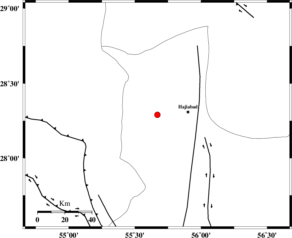
| Location | Lat:28.29 Lon: 55.67 |
| Region | Hormozgan Province, 23 km West of Hajiabad |
Nearest Cities |
|
| 23 km West of Hajiabad, Hormozgan Province | |
| 45 km South East of Tal bargah, Fars Province | |
| 46 km East of Doborji, Fars Province | |
| 48 km North East of Fadami, Fars Province | |
| 53 km North East of Darz, Fars Province | |
| Depth | 14 km |
| Agency | |
Faults within 150 km: |
|
| MAIN_ZAGROS_R_F (Length: 1106 km) , Distance to epicenter: 6 km | |
| HZF2 (Length: 437 km) , Distance to epicenter: 6 km | |
| HZF1 (Length: 102 km) , Distance to epicenter: 56 km | |
| Number of Phases | 4 |
| RMS | 0.1 |
| Number of Stations | 3 |
| Error in Latitude | >1.6 km |
| Error in Longitude | 3.7 km |
| Error in Depth | 5.8 km |
Download waveform in seisan format
to download seisan software Click here
to access information about IIEES stations Click here
Amplitude | ||||||||
| UID | Agency | Station | Component | Amplitude | Period | Arrival Time | Proccessing Time | Signal Clip |
| 84184 | IIEES | BNDS | E | 220.5 | 0.32 | 2012-06-17 12:36:39 | 2012-06-17 12:52:00 | n |
| 84185 | IIEES | KRBR | N | 73.6 | 0.4 | 2012-06-17 12:37:08 | 2012-06-17 12:52:00 | n |
| 84186 | IIEES | KRBR | E | 85.8 | 0.4 | 2012-06-17 12:37:09 | 2012-06-17 12:52:00 | n |
Phase | ||||||||||||
| Agency | Station | Component | Phase Type | Phase Quality | First Motion | Observed Arrival Time | Time Residual | Loc. Flag | Input Weight | Distance | Azimuth | |
| IIEES | BNDS | Z | Pg | E | 2012-06-17 12:36:18 | -0.02 | y | 110 | 153 | |||
| IIEES | KRBR | Z | Pn | E | 2012-06-17 12:36:34 | 0.11 | y | 216 | 29 | |||
| IIEES | KRBR | N | Sg | E | 2012-06-17 12:37:01 | -0.06 | y | 216 | 29 | |||
| IIEES | GHIR | Z | Pn | E | 2012-06-17 12:36:40 | -0.03 | y | 263 | 271 | |||