
Magnitude |
:3.5 |
| Date & Time (UTC) | 2012-06-16 13:40:36.2 |
| Date & Time (Local) | 1391/3/27 18:10:36.2 |
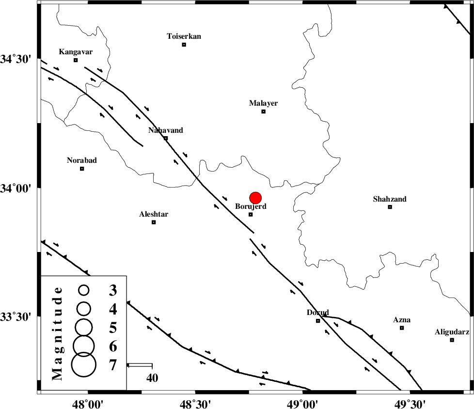
| Location | Lat:33.96 Lon: 48.78 |
| Region | Lorestan Province, 7 km Borujerd |
Nearest Cities |
|
| 7 km North of Borujerd, Lorestan Province | |
| 11 km East of Bon dizeh, Lorestan Province | |
| 12 km of Darre-ye gorg, Lorestan Province | |
| 12 km North of Valanjerd, Lorestan Province | |
| 14 km East of Ashtarinan, Lorestan Province | |
| Depth | 15 km |
| Agency | |
Faults within 150 km: |
|
| NAHAVAND_F (Length: 102 km) , Distance to epicenter: 12 km | |
| DORUD (Length: 100 km) , Distance to epicenter: 18 km | |
| SAHANEH_F (Length: 77 km) , Distance to epicenter: 53 km | |
| Number of Phases | 7 |
| RMS | 0.2 |
| Number of Stations | 6 |
| Error in Latitude | >7.1 km |
| Error in Longitude | 4.7 km |
| Error in Depth | 5.1 km |
Download waveform in seisan format
to download seisan software Click here
to access information about IIEES stations Click here
Amplitude | ||||||||
| UID | Agency | Station | Component | Amplitude | Period | Arrival Time | Proccessing Time | Signal Clip |
| 84169 | IIEES | GHVR | N | 241.6 | 0.44 | 2012-06-16 13:41:48 | 2012-06-16 02:01:00 | n |
| 84170 | IIEES | GHVR | E | 383 | 0.44 | 2012-06-16 13:41:49 | 2012-06-16 02:01:00 | n |
Phase | ||||||||||||
| Agency | Station | Component | Phase Type | Phase Quality | First Motion | Observed Arrival Time | Time Residual | Loc. Flag | Input Weight | Distance | Azimuth | |
| IIEES | KHMZ | Z | Pg | E | 2012-06-16 13:40:55 | -0.04 | y | 112 | 102 | |||
| IIEES | KHMZ | E | Sg | E | 2012-06-16 13:41:09 | -0.09 | y | 112 | 102 | |||
| IIEES | ASAO | Z | Pg | E | 2012-06-16 13:40:58 | -0.38 | y | 132 | 60 | |||
| IIEES | SNGE | Z | Pg | E | 2012-06-16 13:41:06 | -0.2 | y | 182 | 314 | |||
| IIEES | GHVR | Z | Pn | E | 2012-06-16 13:41:13 | 0.4 | y | 235 | 75 | |||
| IIEES | THKV | Z | Pn | E | 2012-06-16 13:41:20 | 0.14 | y | 290 | 41 | |||
| IIEES | ZNJK | Z | Pn | E | 2012-06-16 13:41:21 | 0.18 | y | 301 | 358 | |||