
Magnitude |
:2.2 |
| Date & Time (UTC) | 2012-06-11 05:23:55.6 |
| Date & Time (Local) | 1391/3/22 09:53:55.6 |
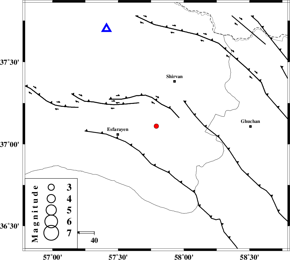
| Location | Lat:37.11 Lon: 57.79 |
| Region | Khorasan(north) Province, 27 km East of Esfarayen |
Nearest Cities |
|
| 16 km South West of Geliyan, Khorasan(north) Province | |
| 17 km North East of Parkanlu, Khorasan(north) Province | |
| 23 km South of Zavarom, Khorasan(north) Province | |
| 25 km West of Maviyan, Khorasan(center) Province | |
| 26 km North West of Bam, Khorasan(north) Province | |
| Depth | 14 km |
| Agency | |
Faults within 150 km: |
|
| ESFARAYEN_F (Length: 111 km) , Distance to epicenter: 18 km | |
| RIVAND_F (Length: 70 km) , Distance to epicenter: 36 km | |
| BAGHAN_GERMAB_F (Length: 79 km) , Distance to epicenter: 41 km | |
| Number of Phases | 5 |
| RMS | 0.1 |
| Number of Stations | 3 |
| Error in Latitude | >1.4 km |
| Error in Longitude | 3.3 km |
| Error in Depth | 10.1 km |
Download waveform in seisan format
to download seisan software Click here
to access information about IIEES stations Click here
Amplitude | ||||||||
| UID | Agency | Station | Component | Amplitude | Period | Arrival Time | Proccessing Time | Signal Clip |
| 84097 | IIEES | BJRD | E | 104.5 | 0.18 | 2012-06-11 05:24:18 | 2012-06-11 05:54:00 | n |
| 84098 | IIEES | MRVT | N | 38.5 | 0.36 | 2012-06-11 05:24:45 | 2012-06-11 05:54:00 | n |
| 84099 | IIEES | MRVT | E | 38.7 | 0.27 | 2012-06-11 05:24:47 | 2012-06-11 05:54:00 | n |
Phase | ||||||||||||
| Agency | Station | Component | Phase Type | Phase Quality | First Motion | Observed Arrival Time | Time Residual | Loc. Flag | Input Weight | Distance | Azimuth | |
| IIEES | BJRD | Z | Pg | E | 2012-06-11 05:24:08 | 0.08 | y | 73.5 | 332 | |||
| IIEES | BJRD | E | Sg | E | 2012-06-11 05:24:17 | -0.09 | y | 73.5 | 332 | |||
| IIEES | MRVT | Z | P | E | 2012-06-11 05:24:22 | 0.06 | y | 163 | 292 | |||
| IIEES | MRVT | N | Sg | E | 2012-06-11 05:24:42 | 0.03 | y | 163 | 292 | |||
| IIEES | SHRO | Z | Pg | E | 2012-06-11 05:24:28 | -0.07 | y | 201 | 233 | |||