
Magnitude |
:2.7 |
| Date & Time (UTC) | 2012-06-06 20:41:48.2 |
| Date & Time (Local) | 1391/3/18 01:11:48.2 |
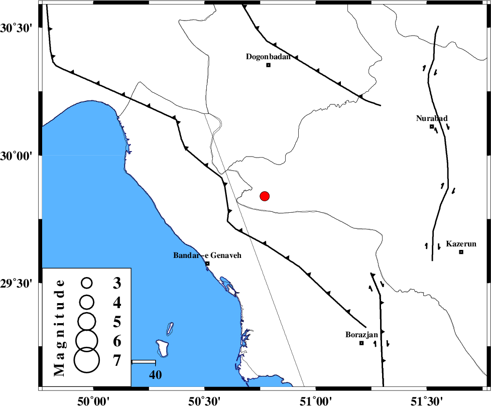
| Location | Lat:29.84 Lon: 50.77 |
| Region | Fars Province, 39 km North-East of Bandar-e genaveh |
Nearest Cities |
|
| 26 km North East of Mohammad salehi, Bushehr Province | |
| 32 km North of Chehar rustaee, Bushehr Province | |
| 39 km North East of Bandar-e genaveh, Bushehr Province | |
| 42 km North East of Bandarehrig, Bushehr Province | |
| 46 km North West of Dehkohneh, Bushehr Province | |
| Depth | 18 km |
| Agency | |
Faults within 150 km: |
|
| ZFF3 (Length: 125 km) , Distance to epicenter: 17 km | |
| RAG_E_SEFID_F (Length: 84 km) , Distance to epicenter: 51 km | |
| BORAZJAN_F (Length: 168 km) , Distance to epicenter: 57 km | |
| Number of Phases | 6 |
| RMS | 0.1 |
| Number of Stations | 4 |
| Error in Latitude | >2.7 km |
| Error in Longitude | 3.7 km |
| Error in Depth | 5.4 km |
Download waveform in seisan format
to download seisan software Click here
to access information about IIEES stations Click here
Amplitude | ||||||||
| UID | Agency | Station | Component | Amplitude | Period | Arrival Time | Proccessing Time | Signal Clip |
| 83970 | IIEES | AHRM | N | 169.4 | 0.76 | 2012-06-06 20:42:28 | 2012-06-06 09:51:00 | n |
| 83971 | IIEES | AHRM | E | 176.5 | 0.76 | 2012-06-06 20:42:30 | 2012-06-06 09:51:00 | n |
| 83972 | IIEES | GHIR | N | 39.3 | 0.72 | 2012-06-06 20:43:23 | 2012-06-06 09:51:00 | n |
| 83973 | IIEES | GHIR | E | 35.7 | 0.6 | 2012-06-06 20:43:24 | 2012-06-06 09:51:00 | n |
Phase | ||||||||||||
| Agency | Station | Component | Phase Type | Phase Quality | First Motion | Observed Arrival Time | Time Residual | Loc. Flag | Input Weight | Distance | Azimuth | |
| IIEES | AHRM | Z | Pg | E | 2012-06-06 20:42:08 | 0.1 | y | 120 | 155 | |||
| IIEES | AHRM | N | Sg | E | 2012-06-06 20:42:22 | -0.04 | y | 120 | 155 | |||
| IIEES | GHIR | Z | Pn | E | 2012-06-06 20:42:29 | -0.15 | y | 277 | 128 | |||
| IIEES | GHIR | N | Sg | E | 2012-06-06 20:43:06 | 0.06 | y | 277 | 128 | |||
| IIEES | KHMZ | Z | Pn | E | 2012-06-06 20:42:50 | 0.03 | y | 439 | 350 | |||
| IIEES | ASAO | Z | Pn | E | 2012-06-06 20:43:01 | 0.01 | y | 526 | 353 | |||