
Magnitude |
:2.9 |
| Date & Time (UTC) | 2012-06-04 19:04:19.9 |
| Date & Time (Local) | 1391/3/15 23:34:19.9 |
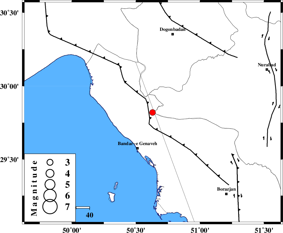
| Location | Lat:29.82 Lon: 50.63 |
| Region | Bushehr Province, 29 km North-East of Bandar-e genaveh |
Nearest Cities |
|
| 19 km North of Mohammad salehi, Bushehr Province | |
| 29 km North East of Bandar-e genaveh, Bushehr Province | |
| 34 km North West of Chehar rustaee, Bushehr Province | |
| 36 km East of Emamhasan, Bushehr Province | |
| 37 km North of Bandarehrig, Bushehr Province | |
| Depth | 46 km |
| Agency | |
Faults within 150 km: |
|
| ZFF3 (Length: 125 km) , Distance to epicenter: 5 km | |
| RAG_E_SEFID_F (Length: 84 km) , Distance to epicenter: 43 km | |
| BORAZJAN_F (Length: 168 km) , Distance to epicenter: 67 km | |
| Number of Phases | 5 |
| RMS | 0.3 |
| Number of Stations | 3 |
| Error in Latitude | >6.6 km |
| Error in Longitude | 9.1 km |
| Error in Depth | 8.9 km |
Download waveform in seisan format
to download seisan software Click here
to access information about IIEES stations Click here
Amplitude | ||||||||
| UID | Agency | Station | Component | Amplitude | Period | Arrival Time | Proccessing Time | Signal Clip |
| 83919 | IIEES | AHRM | N | 268 | 0.52 | 2012-06-04 19:04:58 | 2012-06-05 12:42:00 | n |
| 83920 | IIEES | AHRM | E | 203.1 | 0.56 | 2012-06-04 19:05:01 | 2012-06-05 12:42:00 | n |
| 83921 | IIEES | GHIR | N | 52.7 | 0.4 | 2012-06-04 19:05:46 | 2012-06-05 12:42:00 | n |
| 83922 | IIEES | GHIR | E | 49.9 | 0.36 | 2012-06-04 19:05:49 | 2012-06-05 12:42:00 | n |
Phase | ||||||||||||
| Agency | Station | Component | Phase Type | Phase Quality | First Motion | Observed Arrival Time | Time Residual | Loc. Flag | Input Weight | Distance | Azimuth | |
| IIEES | AHRM | Z | Pg | E | 2012-06-04 19:04:40 | -0.12 | y | 124 | 148 | |||
| IIEES | AHRM | N | Sg | E | 2012-06-04 19:04:56 | 0.35 | y | 124 | 148 | |||
| IIEES | GHIR | Z | Pn | E | 2012-06-04 19:04:59 | -0.42 | y | 286 | 126 | |||
| IIEES | GHIR | N | Sg | E | 2012-06-04 19:05:38 | -0.06 | y | 286 | 126 | |||
| IIEES | NASN | Z | Pn | E | 2012-06-04 19:05:13 | 0.28 | y | 390 | 32 | |||