
Magnitude |
:2.9 |
| Date & Time (UTC) | 2012-06-04 16:47:59.4 |
| Date & Time (Local) | 1391/3/15 21:17:59.4 |
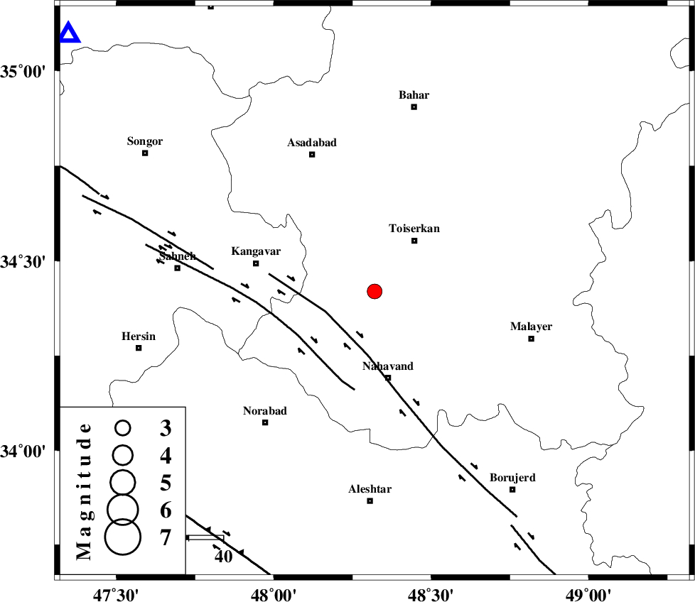
| Location | Lat:34.42 Lon: 48.32 |
| Region | Hamedan Province, 19 km South-West of Tuyserkan |
Nearest Cities |
|
| 8 km of Farsang, Hamedan Province | |
| 10 km North West of Miyandeh, Hamedan Province | |
| 15 km South of Jaefaryeh, Hamedan Province | |
| 16 km North East of Firuzan, Hamedan Province | |
| 19 km West of Seyyed shahab, Hamedan Province | |
| Depth | 15 km |
| Agency | |
Faults within 150 km: |
|
| NAHAVAND_F (Length: 102 km) , Distance to epicenter: 15 km | |
| SAHANEH_F (Length: 77 km) , Distance to epicenter: 26 km | |
| DINEHVAR_F (Length: 46 km) , Distance to epicenter: 47 km | |
| Number of Phases | 7 |
| RMS | 0.4 |
| Number of Stations | 6 |
| Error in Latitude | >7.8 km |
| Error in Longitude | 6.1 km |
| Error in Depth | 5.7 km |
Download waveform in seisan format
to download seisan software Click here
to access information about IIEES stations Click here
Amplitude | ||||||||
| UID | Agency | Station | Component | Amplitude | Period | Arrival Time | Proccessing Time | Signal Clip |
| 83911 | IIEES | SNGE | N | 388.7 | 0.34 | 2012-06-04 16:48:33 | 2012-06-04 05:23:00 | n |
| 83912 | IIEES | SNGE | E | 584.1 | 0.16 | 2012-06-04 16:48:34 | 2012-06-04 05:23:00 | n |
| 83913 | IIEES | KHMZ | E | 126.4 | 0.32 | 2012-06-04 16:48:52 | 2012-06-04 05:23:00 | n |
| 83914 | IIEES | KHMZ | N | 123.2 | 0.36 | 2012-06-04 16:48:52 | 2012-06-04 05:23:00 | n |
| 83915 | IIEES | GHVR | E | 56.4 | 0.41 | 2012-06-04 16:49:16 | 2012-06-04 05:23:00 | n |
| 83916 | IIEES | GHVR | N | 48.6 | 0.34 | 2012-06-04 16:49:17 | 2012-06-04 05:23:00 | n |
Phase | ||||||||||||
| Agency | Station | Component | Phase Type | Phase Quality | First Motion | Observed Arrival Time | Time Residual | Loc. Flag | Input Weight | Distance | Azimuth | |
| IIEES | SNGE | Z | Pg | E | 2012-06-04 16:48:19 | 0.02 | y | 116 | 310 | |||
| IIEES | SNGE | N | Sg | E | 2012-06-04 16:48:33 | -0.21 | y | 116 | 310 | |||
| IIEES | ASAO | Z | Pg | E | 2012-06-04 16:48:24 | -0.79 | y | 158 | 84 | |||
| IIEES | KHMZ | Z | Pn | E | 2012-06-04 16:48:28 | 0.14 | y | 170 | 116 | |||
| IIEES | KHMZ | E | Sg | E | 2012-06-04 16:48:48 | 0.15 | y | 170 | 116 | |||
| IIEES | ZNJK | Z | Pn | E | 2012-06-04 16:48:38 | 0.46 | y | 252 | 8 | |||
| IIEES | CHTH | E | Pn | E | 2012-06-04 16:48:45 | 0.25 | y | 304 | 56 | |||