
Magnitude |
:3.2 |
| Date & Time (UTC) | 2012-06-01 09:34:34.8 |
| Date & Time (Local) | 1391/3/12 14:04:34.8 |
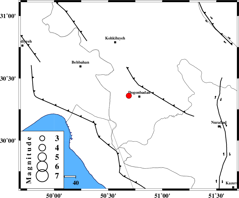
| Location | Lat:30.36 Lon: 50.69 |
| Region | Kohkiluieh va boyerahmad Province, 9 km Dogonbadan |
Nearest Cities |
|
| 9 km North of Dogonbadan, Kohkiluieh va boyerahmad Province | |
| 36 km West of Abdehgah, Kohkiluieh va boyerahmad Province | |
| 45 km North East of Sardasht, Khoozestan Province | |
| 45 km North West of Basht, Kohkiluieh va boyerahmad Province | |
| 48 km North East of Siyahmakan-e bozorg, Bushehr Province | |
| Depth | 43 km |
| Agency | |
Faults within 150 km: |
|
| MISHAN_F (Length: 76 km) , Distance to epicenter: 13 km | |
| ZFF3 (Length: 125 km) , Distance to epicenter: 39 km | |
| RAG_E_SEFID_F (Length: 84 km) , Distance to epicenter: 39 km | |
| Number of Phases | 5 |
| RMS | 0.1 |
| Number of Stations | 5 |
| Error in Latitude | >3.1 km |
| Error in Longitude | 4.2 km |
| Error in Depth | 6 km |
Download waveform in seisan format
to download seisan software Click here
to access information about IIEES stations Click here
Amplitude | ||||||||
| UID | Agency | Station | Component | Amplitude | Period | Arrival Time | Proccessing Time | Signal Clip |
| 83839 | IIEES | AHRM | N | 203 | 0.52 | 2012-06-01 09:35:31 | 2012-06-01 09:59:00 | n |
| 83840 | IIEES | SHGR | E | 168.5 | 0.52 | 2012-06-01 09:35:57 | 2012-06-01 09:59:00 | n |
| 83841 | IIEES | GHIR | E | 68.1 | 0.56 | 2012-06-01 09:36:23 | 2012-06-01 09:59:00 | n |
Phase | ||||||||||||
| Agency | Station | Component | Phase Type | Phase Quality | First Motion | Observed Arrival Time | Time Residual | Loc. Flag | Input Weight | Distance | Azimuth | |
| IIEES | AHRM | Z | Pg | E | 2012-06-01 09:35:03 | 0 | y | 176 | 160 | |||
| IIEES | SHGR | Z | Pn | E | 2012-06-01 09:35:12 | -0.1 | y | 264 | 318 | |||
| IIEES | GHIR | Z | Pn | E | 2012-06-01 09:35:19 | 0.03 | y | 320 | 135 | |||
| IIEES | NASN | Z | Pn | E | 2012-06-01 09:35:21 | -0.11 | y | 336 | 36 | |||
| IIEES | KHMZ | Z | Pn | E | 2012-06-01 09:35:27 | 0.21 | y | 381 | 350 | |||