
Magnitude |
:2.7 |
| Date & Time (UTC) | 2012-05-28 10:12:01.8 |
| Date & Time (Local) | 1391/3/8 14:42:01.8 |
| Location | Lat:28.36 Lon: 58.77 |
| Region | Kerman Province, 92 km South-East of Bam |
Nearest Cities |
|
| 40 km South of Mohammadabad-e gonbaki, Kerman Province | |
| 45 km North East of Borj-e abbasabad, Kerman Province | |
| 48 km South West of Hoseynabad, Kerman Province | |
| 58 km South West of Void, Kerman Province | |
| 58 km North East of Mardehak, Kerman Province | |
| Depth | 14 km |
| Agency | |
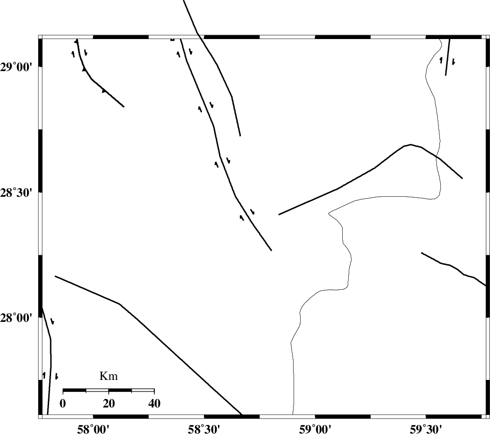
Faults within 150 km: |
|
| BAM_F (Length: 118 km) , Distance to epicenter: 6 km | |
| GOWK_F (Length: 152 km) , Distance to epicenter: 82 km | |
| SABZEVARAN_F (Length: 190 km) , Distance to epicenter: 102 km | |
| Number of Phases | 5 |
| RMS | 0.3 |
| Number of Stations | 3 |
| Error in Latitude | >7.6 km |
| Error in Longitude | 4.8 km |
| Error in Depth | 6.8 km |
Download waveform in seisan format
to download seisan software Click here
to access information about IIEES stations Click here
Amplitude | ||||||||
| UID | Agency | Station | Component | Amplitude | Period | Arrival Time | Proccessing Time | Signal Clip |
| 83794 | IIEES | ZHSF | N | 45.2 | 0.31 | 2012-05-28 10:13:11 | 2012-05-28 10:44:00 | n |
| 83795 | IIEES | BNDS | E | 46.9 | 0.29 | 2012-05-28 10:13:28 | 2012-05-28 10:44:00 | n |
Phase | ||||||||||||
| Agency | Station | Component | Phase Type | Phase Quality | First Motion | Observed Arrival Time | Time Residual | Loc. Flag | Input Weight | Distance | Azimuth | |
| IIEES | ZHSF | Z | Pn | E | 2012-05-28 10:12:39 | -0.27 | y | 239 | 54 | |||
| IIEES | ZHSF | E | Sg | E | 2012-05-28 10:13:09 | 0.06 | y | 239 | 54 | |||
| IIEES | KRBR | Z | Pn | E | 2012-05-28 10:12:42 | 0.04 | y | 265 | 313 | |||
| IIEES | BNDS | Z | Pn | E | 2012-05-28 10:12:44 | 0.45 | y | 277 | 248 | |||
| IIEES | BNDS | E | Sg | E | 2012-05-28 10:13:19 | -0.27 | y | 277 | 248 | |||