
Magnitude |
:2.7 |
| Date & Time (UTC) | 2012-05-15 15:50:50.6 |
| Date & Time (Local) | 1391/2/26 20:20:50.6 |
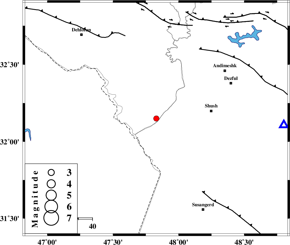
| Location | Lat:32.15 Lon: 47.83 |
| Region | Ilam Province, 40 km West of Shush |
Nearest Cities |
|
| 40 km West of Shush, Khoozestan Province | |
| 42 km West of Amaleh teimur, Khoozestan Province | |
| 50 km North West of Bostan, Khoozestan Province | |
| 59 km South West of Shamsabad, Khoozestan Province | |
| 59 km South West of Dezful, Khoozestan Province | |
| Depth | 17 km |
| Agency | |
Faults within 150 km: |
|
| DEZFUL_EMBAYMENT (Length: 228 km) , Distance to epicenter: 59 km | |
| AHVAZ_F (Length: 99 km) , Distance to epicenter: 62 km | |
| MFF6 (Length: 144 km) , Distance to epicenter: 63 km | |
| Number of Phases | 5 |
| RMS | 0.1 |
| Number of Stations | 4 |
| Error in Latitude | >2.8 km |
| Error in Longitude | 4.9 km |
| Error in Depth | 6 km |
Download waveform in seisan format
to download seisan software Click here
to access information about IIEES stations Click here
Amplitude | ||||||||
| UID | Agency | Station | Component | Amplitude | Period | Arrival Time | Proccessing Time | Signal Clip |
| 83584 | IIEES | KHMZ | N | 37.4 | 0.6 | 2012-05-15 15:52:14 | 2012-05-15 04:48:00 | n |
| 83585 | IIEES | KHMZ | E | 40.8 | 0.52 | 2012-05-15 15:52:17 | 2012-05-15 04:48:00 | n |
| 83586 | IIEES | SNGE | N | 23.2 | 0.4 | 2012-05-15 15:52:24 | 2012-05-15 04:48:00 | n |
| 83587 | IIEES | SNGE | E | 33 | 0.56 | 2012-05-15 15:52:28 | 2012-05-15 04:48:00 | n |
Phase | ||||||||||||
| Agency | Station | Component | Phase Type | Phase Quality | First Motion | Observed Arrival Time | Time Residual | Loc. Flag | Input Weight | Distance | Azimuth | |
| IIEES | SHGR | Z | Pg | E | 2012-05-15 15:51:06 | 0 | y | 91.7 | 92 | |||
| IIEES | KHMZ | Z | Pn | E | 2012-05-15 15:51:31 | -0.13 | y | 266 | 48 | |||
| IIEES | KHMZ | E | Sg | E | 2012-05-15 15:52:05 | 0 | y | 266 | 48 | |||
| IIEES | SNGE | Z | Pn | E | 2012-05-15 15:51:39 | 0.01 | y | 330 | 352 | |||
| IIEES | GHVR | Z | Pn | E | 2012-05-15 15:51:49 | 0.16 | y | 410 | 50 | |||