
Magnitude |
:3.6 |
| Date & Time (UTC) | 2012-05-13 19:28:02.4 |
| Date & Time (Local) | 1391/2/24 23:58:02.4 |
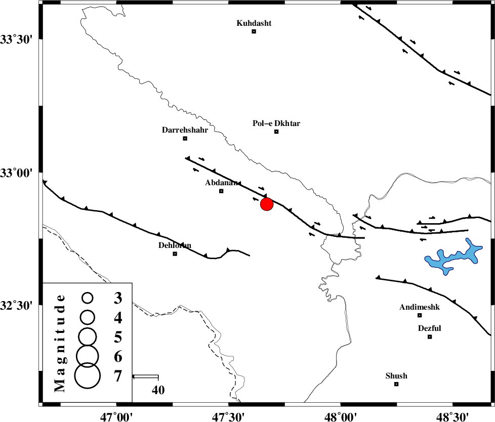
| Location | Lat:32.88 Lon: 47.67 |
| Region | Ilam Province, 20 km East of Abdanan |
Nearest Cities |
|
| 10 km East of Sarabbagh, Ilam Province | |
| 20 km East of Abdanan, Ilam Province | |
| 24 km South of Sarab hammam, Lorestan Province | |
| 31 km South of Pol-e dokhtar, Lorestan Province | |
| 41 km South of Morani, Lorestan Province | |
| Depth | 14 km |
| Agency | |
Faults within 150 km: |
|
| BALARUD_F_Z1 (Length: 87 km) , Distance to epicenter: 7 km | |
| MFF6 (Length: 144 km) , Distance to epicenter: 23 km | |
| BALARUD_F_Z3 (Length: 53 km) , Distance to epicenter: 36 km | |
| Number of Phases | 6 |
| RMS | 0.1 |
| Number of Stations | 5 |
| Error in Latitude | >2.2 km |
| Error in Longitude | 3.1 km |
| Error in Depth | 4.9 km |
Download waveform in seisan format
to download seisan software Click here
to access information about IIEES stations Click here
Amplitude | ||||||||
| UID | Agency | Station | Component | Amplitude | Period | Arrival Time | Proccessing Time | Signal Clip |
| 83504 | IIEES | SHGR | N | 1088.4 | 0.28 | 2012-05-13 19:28:46 | 2012-05-13 07:53:00 | n |
| 83505 | IIEES | SHGR | E | 1240.4 | 0.48 | 2012-05-13 19:28:47 | 2012-05-13 07:53:00 | n |
| 83506 | IIEES | GHVR | E | 179.9 | 0.6 | 2012-05-13 19:29:44 | 2012-05-13 07:53:00 | n |
| 83507 | IIEES | GHVR | N | 131.7 | 0.56 | 2012-05-13 19:29:54 | 2012-05-13 07:53:00 | n |
Phase | ||||||||||||
| Agency | Station | Component | Phase Type | Phase Quality | First Motion | Observed Arrival Time | Time Residual | Loc. Flag | Input Weight | Distance | Azimuth | |
| IIEES | SHGR | Z | Pg | E | 2012-05-13 19:28:25 | -0.03 | y | 136 | 129 | |||
| IIEES | KHMZ | Z | Pn | E | 2012-05-13 19:28:39 | -0.04 | y | 234 | 65 | |||
| IIEES | KHMZ | N | Sg | E | 2012-05-13 19:29:08 | -0.04 | y | 234 | 65 | |||
| IIEES | SNGE | Z | Pn | E | 2012-05-13 19:28:40 | -0.05 | y | 247 | 353 | |||
| IIEES | ASAO | Z | Pn | E | 2012-05-13 19:28:45 | 0.04 | y | 286 | 49 | |||
| IIEES | GHVR | Z | Pn | E | 2012-05-13 19:28:56 | 0.15 | y | 376 | 61 | |||