
Magnitude |
:3.6 |
| Date & Time (UTC) | 2012-05-13 13:48:13.6 |
| Date & Time (Local) | 1391/2/24 18:18:13.6 |
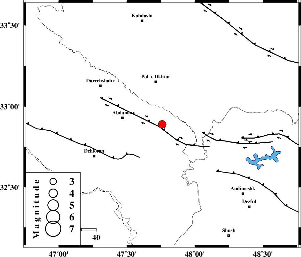
| Location | Lat:32.89 Lon: 47.76 |
| Region | Ilam Province, 30 km South of Pol-e dokhtar |
Nearest Cities |
|
| 18 km East of Sarabbagh, Ilam Province | |
| 24 km South of Sarab hammam, Lorestan Province | |
| 28 km East of Abdanan, Ilam Province | |
| 30 km South of Pol-e dokhtar, Lorestan Province | |
| 40 km South of Morani, Lorestan Province | |
| Depth | 14 km |
| Agency | |
Faults within 150 km: |
|
| BALARUD_F_Z1 (Length: 87 km) , Distance to epicenter: 3 km | |
| MFF6 (Length: 144 km) , Distance to epicenter: 28 km | |
| BALARUD_F_Z3 (Length: 53 km) , Distance to epicenter: 28 km | |
| Number of Phases | 7 |
| RMS | 0.1 |
| Number of Stations | 6 |
| Error in Latitude | >2.2 km |
| Error in Longitude | 3 km |
| Error in Depth | 5 km |
Download waveform in seisan format
to download seisan software Click here
to access information about IIEES stations Click here
Amplitude | ||||||||
| UID | Agency | Station | Component | Amplitude | Period | Arrival Time | Proccessing Time | Signal Clip |
| 83491 | IIEES | SHGR | E | 919.3 | 0.64 | 2012-05-13 13:48:56 | 2012-05-13 02:04:00 | n |
| 83492 | IIEES | SHGR | N | 776.3 | 0.64 | 2012-05-13 13:49:06 | 2012-05-13 02:04:00 | n |
| 83493 | IIEES | SNGE | N | 490.8 | 0.56 | 2012-05-13 13:49:30 | 2012-05-13 02:04:00 | n |
| 83494 | IIEES | SNGE | E | 378.6 | 0.52 | 2012-05-13 13:49:30 | 2012-05-13 02:04:00 | n |
| 83495 | IIEES | GHVR | E | 149.4 | 0.72 | 2012-05-13 13:49:54 | 2012-05-13 02:04:00 | n |
Phase | ||||||||||||
| Agency | Station | Component | Phase Type | Phase Quality | First Motion | Observed Arrival Time | Time Residual | Loc. Flag | Input Weight | Distance | Azimuth | |
| IIEES | SHGR | Z | Pg | E | 2012-05-13 13:48:35 | -0.05 | y | 130 | 131 | |||
| IIEES | KHMZ | Z | Pn | E | 2012-05-13 13:48:49 | 0.03 | y | 226 | 65 | |||
| IIEES | KHMZ | N | Sg | E | 2012-05-13 13:49:17 | -0.07 | y | 226 | 65 | |||
| IIEES | SNGE | Z | Pn | E | 2012-05-13 13:48:52 | -0.03 | y | 248 | 351 | |||
| IIEES | ASAO | Z | Pn | E | 2012-05-13 13:48:56 | 0.14 | y | 279 | 48 | |||
| IIEES | GHVR | Z | Pn | E | 2012-05-13 13:49:07 | 0.11 | y | 368 | 60 | |||
| IIEES | ZNJK | Z | Pn | E | 2012-05-13 13:49:14 | -0.14 | y | 428 | 11 | |||