
Magnitude |
:3.3 |
| Date & Time (UTC) | 2012-05-11 13:23:56.9 |
| Date & Time (Local) | 1391/2/22 17:53:56.9 |
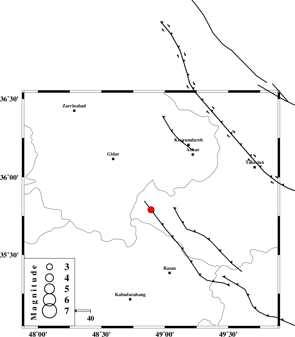
| Location | Lat:35.79 Lon: 48.89 |
| Region | Ghazvin Province, 48 km North-West of Razan |
Nearest Cities |
|
| 23 km North East of Kahla, Zanjan Province | |
| 31 km North of Khorandeh, Hamedan Province | |
| 36 km North West of Ab-e garm, Ghazvin Province | |
| 38 km North East of Zarrinabad, Zanjan Province | |
| 38 km South of Kineh vars, Zanjan Province | |
| Depth | 14 km |
| Agency | |
Faults within 150 km: |
|
| KUSHK_E_NOSRAT_F (Length: 230 km) , Distance to epicenter: 22 km | |
| SOLTANIYEH_F (Length: 119 km) , Distance to epicenter: 32 km | |
| ZANJAN_F (Length: 137 km) , Distance to epicenter: 57 km | |
| Number of Phases | 8 |
| RMS | 0.1 |
| Number of Stations | 6 |
| Error in Latitude | >1.2 km |
| Error in Longitude | 1.4 km |
| Error in Depth | 3.4 km |
Download waveform in seisan format
to download seisan software Click here
to access information about IIEES stations Click here
Amplitude | ||||||||
| UID | Agency | Station | Component | Amplitude | Period | Arrival Time | Proccessing Time | Signal Clip |
| 83468 | IIEES | SNGE | E | 535.3 | 0.48 | 2012-05-11 13:24:45 | 2012-05-11 01:44:00 | n |
| 83469 | IIEES | SNGE | N | 690 | 0.44 | 2012-05-11 13:24:45 | 2012-05-11 01:44:00 | n |
| 83470 | IIEES | THKV | E | 168.6 | 0.64 | 2012-05-11 13:24:58 | 2012-05-11 01:44:00 | n |
Phase | ||||||||||||
| Agency | Station | Component | Phase Type | Phase Quality | First Motion | Observed Arrival Time | Time Residual | Loc. Flag | Input Weight | Distance | Azimuth | |
| IIEES | ZNJK | Z | Pg | E | 2012-05-11 13:24:13 | -0.15 | y | 99 | 349 | |||
| IIEES | SNGE | Z | Pg | E | 2012-05-11 13:24:23 | 0.12 | y | 160 | 241 | |||
| IIEES | SNGE | E | Sg | E | 2012-05-11 13:24:42 | -0.04 | y | 160 | 241 | |||
| IIEES | ASAO | Z | Pg | E | 2012-05-11 13:24:25 | -0.06 | y | 173 | 143 | |||
| IIEES | THKV | Z | Pg | E | 2012-05-11 13:24:26 | 0.12 | y | 180 | 85 | |||
| IIEES | CHTH | Z | Pn | E | 2012-05-11 13:24:30 | -0.02 | y | 203 | 86 | |||
| IIEES | KHMZ | Z | Pn | E | 2012-05-11 13:24:35 | 0.17 | y | 248 | 156 | |||
| IIEES | KHMZ | E | Sg | E | 2012-05-11 13:25:07 | -0.15 | y | 248 | 156 | |||