
Magnitude |
:3.7 |
| Date & Time (UTC) | 2012-05-09 05:23:45.9 |
| Date & Time (Local) | 1391/2/20 09:53:45.9 |
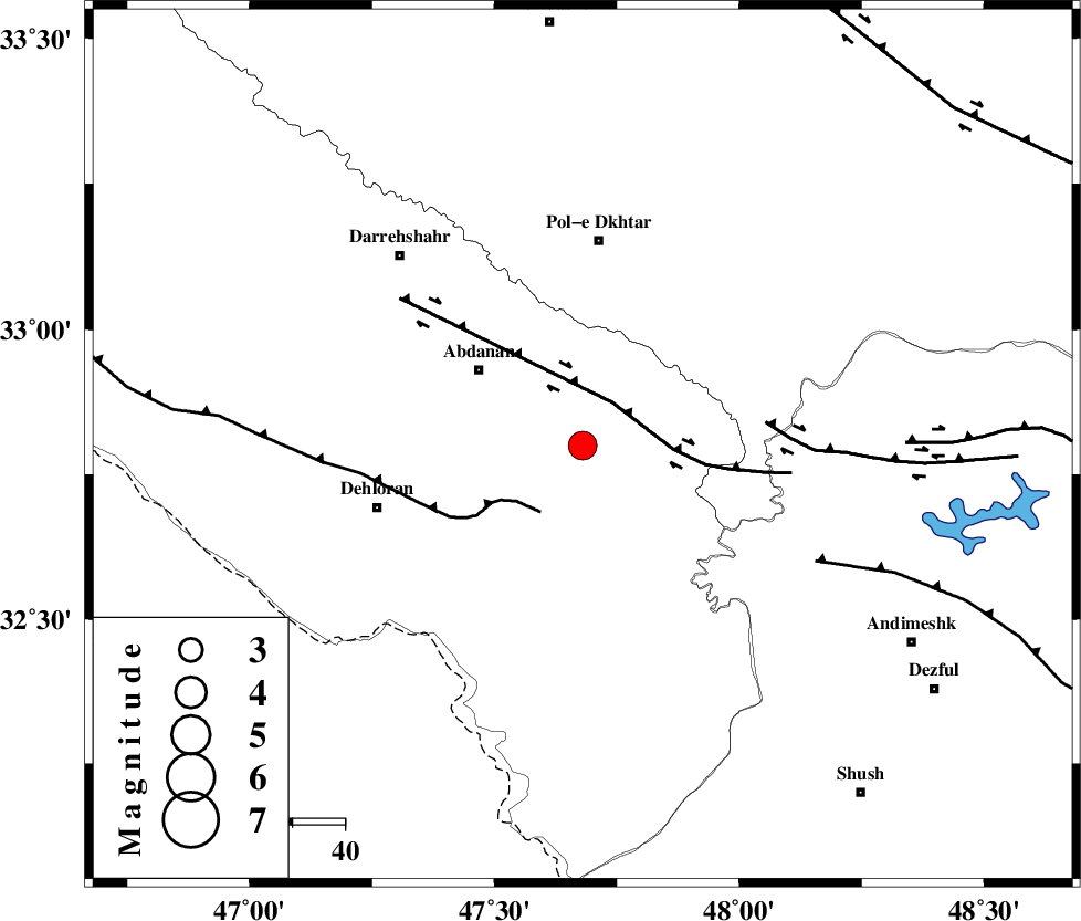
| Location | Lat:32.8 Lon: 47.68 |
| Region | Ilam Province, 24 km South-East of Abdanan |
Nearest Cities |
|
| 15 km East of Sarabbagh, Ilam Province | |
| 25 km South East of Abdanan, Ilam Province | |
| 33 km South of Sarab hammam, Lorestan Province | |
| 39 km South of Pol-e dokhtar, Lorestan Province | |
| 41 km North East of Dehloran, Ilam Province | |
| Depth | 17 km |
| Agency | |
Faults within 150 km: |
|
| BALARUD_F_Z1 (Length: 87 km) , Distance to epicenter: 10 km | |
| MFF6 (Length: 144 km) , Distance to epicenter: 15 km | |
| BALARUD_F_Z3 (Length: 53 km) , Distance to epicenter: 35 km | |
| Number of Phases | 7 |
| RMS | 0.2 |
| Number of Stations | 6 |
| Error in Latitude | >4.4 km |
| Error in Longitude | 8.9 km |
| Error in Depth | 5.1 km |
Download waveform in seisan format
to download seisan software Click here
to access information about IIEES stations Click here
Amplitude | ||||||||
| UID | Agency | Station | Component | Amplitude | Period | Arrival Time | Proccessing Time | Signal Clip |
| 83392 | IIEES | SHGR | E | 2036.4 | 0.25 | 2012-05-09 05:24:28 | 2012-05-09 05:48:00 | n |
| 83393 | IIEES | KHMZ | N | 487.6 | 0.53 | 2012-05-09 05:24:55 | 2012-05-09 05:48:00 | n |
| 83394 | IIEES | KHMZ | E | 421.2 | 0.67 | 2012-05-09 05:24:57 | 2012-05-09 05:48:00 | n |
| 83395 | IIEES | SNGE | N | 533 | 0.39 | 2012-05-09 05:25:06 | 2012-05-09 05:48:00 | n |
| 83396 | IIEES | SNGE | E | 394.5 | 0.56 | 2012-05-09 05:25:07 | 2012-05-09 05:48:00 | n |
| 83397 | IIEES | GHVR | N | 153.6 | 0.44 | 2012-05-09 05:25:26 | 2012-05-09 05:48:00 | n |
Phase | ||||||||||||
| Agency | Station | Component | Phase Type | Phase Quality | First Motion | Observed Arrival Time | Time Residual | Loc. Flag | Input Weight | Distance | Azimuth | |
| IIEES | SHGR | Z | Pg | E | 2012-05-09 05:24:07 | -0.02 | y | 131 | 126 | |||
| IIEES | KHMZ | Z | Pn | E | 2012-05-09 05:24:22 | -0.14 | y | 237 | 63 | |||
| IIEES | SNGE | Z | Pn | E | 2012-05-09 05:24:25 | 0.2 | y | 256 | 353 | |||
| IIEES | SNGE | E | Sg | E | 2012-05-09 05:24:58 | 0.02 | y | 256 | 353 | |||
| IIEES | ASAO | Z | Pn | E | 2012-05-09 05:24:29 | 0 | y | 292 | 48 | |||
| IIEES | GHVR | Z | Pn | E | 2012-05-09 05:24:40 | 0.34 | y | 380 | 60 | |||
| IIEES | ZNJK | Z | Pn | E | 2012-05-09 05:24:47 | -0.46 | y | 439 | 12 | |||