
Magnitude |
:5.4 |
| Date & Time (UTC) | 2012-05-03 10:09:37.3 |
| Date & Time (Local) | 1391/2/14 14:39:37.3 |
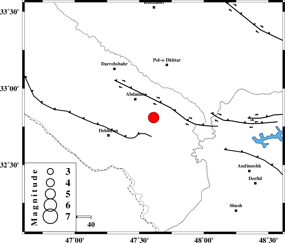
| Location | Lat:32.81 Lon: 47.61 |
| Region | Ilam Province, 19 km South-East of Abdanan |
Nearest Cities |
|
| 11 km of Sarabbagh, Ilam Province | |
| 19 km South East of Abdanan, Ilam Province | |
| 33 km South of Sarab hammam, Lorestan Province | |
| 35 km North East of Dehloran, Ilam Province | |
| 38 km North East of Musian, Ilam Province | |
| Depth | 14 km |
| Agency | |
Faults within 150 km: |
|
| MFF6 (Length: 144 km) , Distance to epicenter: 13 km | |
| BALARUD_F_Z1 (Length: 87 km) , Distance to epicenter: 14 km | |
| BALARUD_F_Z3 (Length: 53 km) , Distance to epicenter: 42 km | |
| Number of Phases | 9 |
| RMS | 0.2 |
| Number of Stations | 9 |
| Error in Latitude | >3.6 km |
| Error in Longitude | 6.7 km |
| Error in Depth | 4.7 km |
Download waveform in seisan format
to download seisan software Click here
to access information about IIEES stations Click here
Amplitude | ||||||||
| UID | Agency | Station | Component | Amplitude | Period | Arrival Time | Proccessing Time | Signal Clip |
| 83220 | IIEES | SHGR | N | 87225.2 | 0.5 | 2012-05-03 10:10:21 | 2012-05-03 10:49:00 | n |
| 83221 | IIEES | SHGR | E | 80443.4 | 0.59 | 2012-05-03 10:10:29 | 2012-05-03 10:49:00 | n |
| 83222 | IIEES | GHVR | N | 4459 | 0.69 | 2012-05-03 10:11:34 | 2012-05-03 10:49:00 | n |
| 83223 | IIEES | GHIR | N | 855.3 | 0.54 | 2012-05-03 10:12:56 | 2012-05-03 10:49:00 | n |
| 83224 | IIEES | GHIR | E | 811.6 | 0.36 | 2012-05-03 10:12:58 | 2012-05-03 10:49:00 | n |
Phase | ||||||||||||
| Agency | Station | Component | Phase Type | Phase Quality | First Motion | Observed Arrival Time | Time Residual | Loc. Flag | Input Weight | Distance | Azimuth | |
| IIEES | SHGR | Z | Pg | E | 2012-05-03 10:10:00 | -0.01 | y | 136 | 124 | |||
| IIEES | KHMZ | Z | Pn | E | 2012-05-03 10:10:15 | -0.22 | y | 243 | 64 | |||
| IIEES | SNGE | Z | Pn | E | 2012-05-03 10:10:17 | 0.33 | y | 254 | 355 | |||
| IIEES | SNGE | E | Sg | E | 2012-05-03 10:10:49 | -0.03 | y | 254 | 355 | |||
| IIEES | ASAO | Z | Pn | E | 2012-05-03 10:10:22 | 0.22 | y | 296 | 49 | |||
| IIEES | GHVR | Z | Pn | E | 2012-05-03 10:10:33 | 0.12 | y | 385 | 60 | |||
| IIEES | ZNJK | Z | Pn | E | 2012-05-03 10:10:39 | -0.14 | y | 440 | 13 | |||
| IIEES | GRMI | Z | Pn | E | 2012-05-03 10:11:07 | -0.43 | y | 666 | 2 | |||
| IIEES | MAKU | Z | Pn | E | 2012-05-03 10:11:20 | -0.2 | y | 773 | 341 | |||