
Magnitude |
:3 |
| Date & Time (UTC) | 2012-04-29 05:37:34.2 |
| Date & Time (Local) | 1391/2/10 10:07:34.2 |
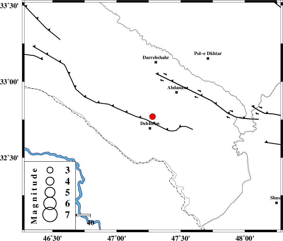
| Location | Lat:32.77 Lon: 47.28 |
| Region | Ilam Province, 8 km Dehloran |
Nearest Cities |
|
| 9 km North of Dehloran, Ilam Province | |
| 25 km South West of Abdanan, Ilam Province | |
| 26 km North of Musian, Ilam Province | |
| 29 km East of Bishehzar, Ilam Province | |
| 30 km South West of Sarabbagh, Ilam Province | |
| Depth | 14 km |
| Agency | |
Faults within 150 km: |
|
| MFF6 (Length: 144 km) , Distance to epicenter: 5 km | |
| BALARUD_F_Z1 (Length: 87 km) , Distance to epicenter: 32 km | |
| BALARUD_F_Z3 (Length: 53 km) , Distance to epicenter: 73 km | |
| Number of Phases | 5 |
| RMS | 0.1 |
| Number of Stations | 4 |
| Error in Latitude | >3.7 km |
| Error in Longitude | 8.6 km |
| Error in Depth | 4.4 km |
Download waveform in seisan format
to download seisan software Click here
to access information about IIEES stations Click here
Amplitude | ||||||||
| UID | Agency | Station | Component | Amplitude | Period | Arrival Time | Proccessing Time | Signal Clip |
| 83150 | IIEES | SHGR | N | 264.6 | 0.3 | 2012-04-29 05:38:26 | 2012-04-29 05:55:00 | n |
| 83151 | IIEES | SHGR | E | 328.9 | 0.56 | 2012-04-29 05:38:32 | 2012-04-29 05:55:00 | n |
| 83152 | IIEES | SNGE | E | 90.6 | 0.75 | 2012-04-29 05:38:55 | 2012-04-29 05:55:00 | n |
| 83153 | IIEES | GHVR | E | 24.4 | 0.53 | 2012-04-29 05:39:26 | 2012-04-29 05:55:00 | n |
| 83154 | IIEES | GHVR | N | 17.1 | 0.53 | 2012-04-29 05:39:26 | 2012-04-29 05:55:00 | n |
Phase | ||||||||||||
| Agency | Station | Component | Phase Type | Phase Quality | First Motion | Observed Arrival Time | Time Residual | Loc. Flag | Input Weight | Distance | Azimuth | |
| IIEES | SHGR | Z | Pg | E | 2012-04-29 05:38:00 | -0.18 | y | 161 | 117 | |||
| IIEES | SNGE | Z | Pn | E | 2012-04-29 05:38:14 | 0.07 | y | 258 | 1 | |||
| IIEES | SNGE | E | Sg | E | 2012-04-29 05:38:47 | -0.13 | y | 258 | 1 | |||
| IIEES | KHMZ | Z | Pn | E | 2012-04-29 05:38:16 | 0.07 | y | 273 | 66 | |||
| IIEES | GHVR | Z | Pn | E | 2012-04-29 05:38:33 | 0.22 | y | 414 | 62 | |||