
Magnitude |
:3.8 |
| Date & Time (UTC) | 2012-04-28 00:34:09.6 |
| Date & Time (Local) | 1391/2/9 05:04:09.6 |
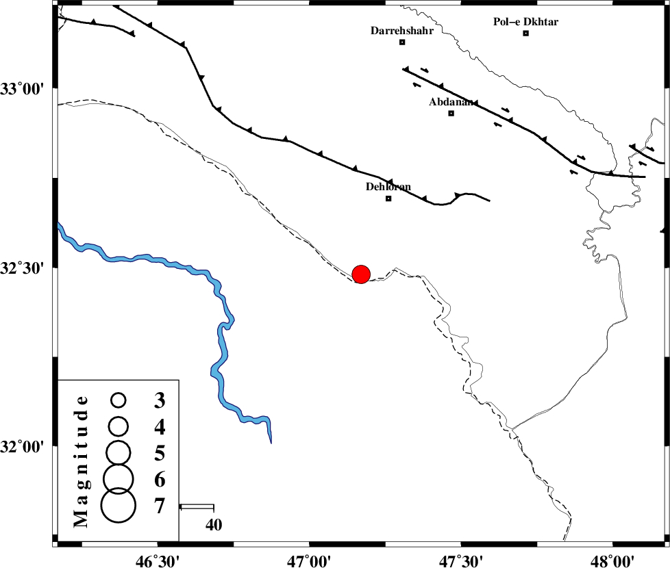
| Location | Lat:32.48 Lon: 47.17 |
| Region | Ilam Province, 25 km South of Dehloran |
Nearest Cities |
|
| 19 km West of Musian, Ilam Province | |
| 25 km South of Dehloran, Ilam Province | |
| 42 km South East of Bishehzar, Ilam Province | |
| 57 km South West of Abdanan, Ilam Province | |
| 59 km South West of Sarabbagh, Ilam Province | |
| Depth | 45 km |
| Agency | |
Faults within 150 km: |
|
| MFF6 (Length: 144 km) , Distance to epicenter: 30 km | |
| BALARUD_F_Z1 (Length: 87 km) , Distance to epicenter: 65 km | |
| BALARUD_F_Z3 (Length: 53 km) , Distance to epicenter: 92 km | |
| Number of Phases | 6 |
| RMS | 0.1 |
| Number of Stations | 5 |
| Error in Latitude | >3.3 km |
| Error in Longitude | 7.1 km |
| Error in Depth | 2.7 km |
Download waveform in seisan format
to download seisan software Click here
to access information about IIEES stations Click here
Amplitude | ||||||||
| UID | Agency | Station | Component | Amplitude | Period | Arrival Time | Proccessing Time | Signal Clip |
| 83140 | IIEES | SHGR | N | 1469.7 | 0.68 | 2012-04-28 00:35:01 | 2012-04-28 01:06:00 | n |
| 83141 | IIEES | SHGR | E | 1512.4 | 0.36 | 2012-04-28 00:35:01 | 2012-04-28 01:06:00 | n |
| 83142 | IIEES | SNGE | E | 252.1 | 0.72 | 2012-04-28 00:35:37 | 2012-04-28 01:06:00 | n |
Phase | ||||||||||||
| Agency | Station | Component | Phase Type | Phase Quality | First Motion | Observed Arrival Time | Time Residual | Loc. Flag | Input Weight | Distance | Azimuth | |
| IIEES | SHGR | Z | Pg | E | 2012-04-28 00:34:35 | 0.01 | y | 159 | 104 | |||
| IIEES | SNGE | Z | Pn | E | 2012-04-28 00:34:50 | -0.01 | y | 291 | 3 | |||
| IIEES | SNGE | E | Sg | E | 2012-04-28 00:35:30 | -0.01 | y | 291 | 3 | |||
| IIEES | KHMZ | Z | Pn | E | 2012-04-28 00:34:51 | -0.09 | y | 296 | 61 | |||
| IIEES | ASAO | Z | Pn | E | 2012-04-28 00:34:58 | 0.17 | y | 351 | 48 | |||
| IIEES | GHVR | Z | Pn | E | 2012-04-28 00:35:08 | -0.07 | y | 439 | 58 | |||