
Magnitude |
:3.3 |
| Date & Time (UTC) | 2012-04-23 23:57:02.8 |
| Date & Time (Local) | 1391/2/5 04:27:02.8 |
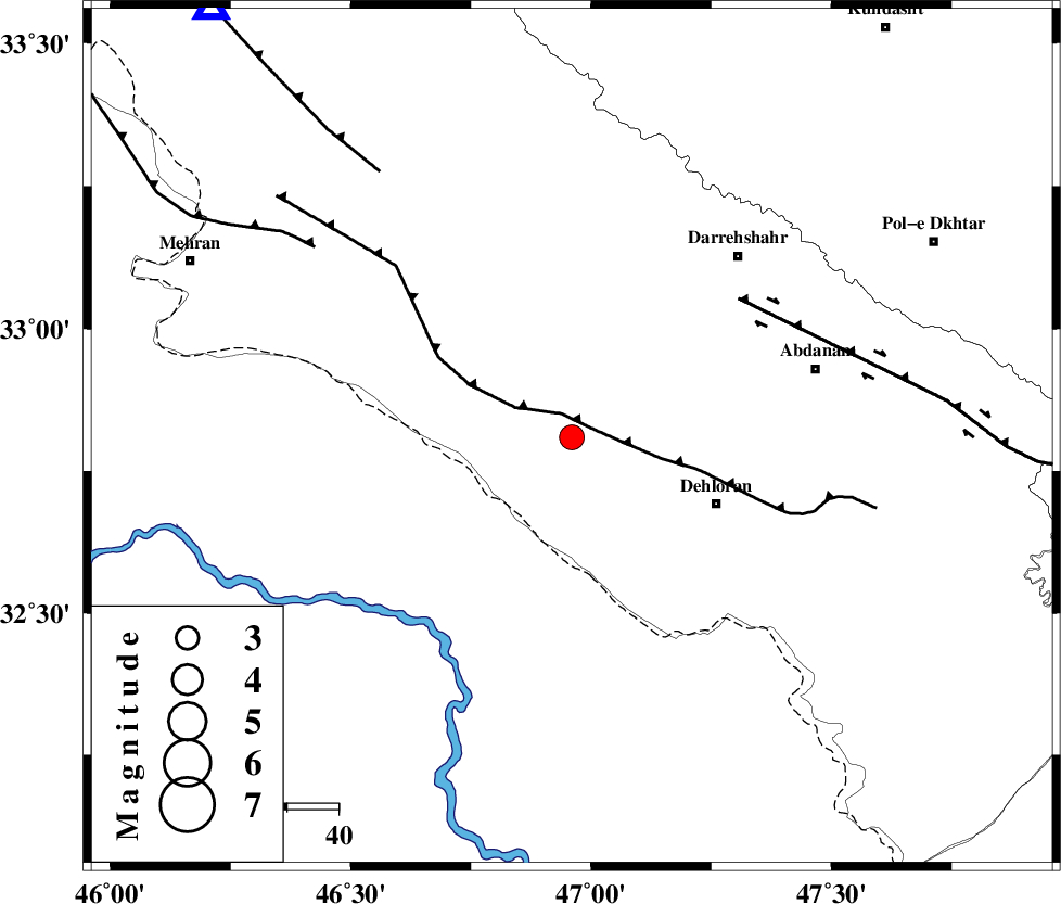
| Location | Lat:32.81 Lon: 46.96 |
| Region | Ilam Province, 31 km North-West of Dehloran |
Nearest Cities |
|
| 2 km of Bishehzar, Ilam Province | |
| 31 km North West of Dehloran, Ilam Province | |
| 47 km South of Meymeh, Ilam Province | |
| 48 km North West of Musian, Ilam Province | |
| 48 km South West of Darreh Shahr, Ilam Province | |
| Depth | 18 km |
| Agency | |
Faults within 150 km: |
|
| MFF6 (Length: 144 km) , Distance to epicenter: 5 km | |
| BALARUD_F_Z1 (Length: 87 km) , Distance to epicenter: 42 km | |
| ZFF4 (Length: 128 km) , Distance to epicenter: 62 km | |
| Number of Phases | 6 |
| RMS | 0.1 |
| Number of Stations | 4 |
| Error in Latitude | >4.4 km |
| Error in Longitude | 9.1 km |
| Error in Depth | 6.7 km |
Download waveform in seisan format
to download seisan software Click here
to access information about IIEES stations Click here
Amplitude | ||||||||
| UID | Agency | Station | Component | Amplitude | Period | Arrival Time | Proccessing Time | Signal Clip |
| 83061 | IIEES | SHGR | E | 780.9 | 0.64 | 2012-04-23 23:58:00 | 2012-04-24 12:19:00 | n |
| 83062 | IIEES | SHGR | N | 630 | 0.6 | 2012-04-23 23:58:07 | 2012-04-24 12:19:00 | n |
| 83063 | IIEES | SNGE | E | 106.3 | 0.6 | 2012-04-23 23:58:24 | 2012-04-24 12:19:00 | n |
| 83064 | IIEES | SNGE | N | 94.6 | 0.6 | 2012-04-23 23:58:31 | 2012-04-24 12:19:00 | n |
| 83065 | IIEES | GHVR | E | 24.5 | 0.72 | 2012-04-23 23:59:20 | 2012-04-24 12:19:00 | n |
| 83066 | IIEES | GHVR | N | 21.6 | 0.6 | 2012-04-23 23:59:25 | 2012-04-24 12:19:00 | n |
Phase | ||||||||||||
| Agency | Station | Component | Phase Type | Phase Quality | First Motion | Observed Arrival Time | Time Residual | Loc. Flag | Input Weight | Distance | Azimuth | |
| IIEES | SHGR | Z | Pn | E | 2012-04-23 23:57:33 | -0.14 | y | 190 | 114 | |||
| IIEES | SHGR | N | Sg | E | 2012-04-23 23:57:56 | 0.1 | y | 190 | 114 | |||
| IIEES | SNGE | Z | Pn | E | 2012-04-23 23:57:42 | 0.19 | y | 256 | 8 | |||
| IIEES | SNGE | N | Sg | E | 2012-04-23 23:58:15 | -0.05 | y | 256 | 8 | |||
| IIEES | KHMZ | E | Pn | E | 2012-04-23 23:57:47 | -0.1 | y | 298 | 69 | |||
| IIEES | GHVR | Z | Pn | E | 2012-04-23 23:58:04 | -0.01 | y | 439 | 64 | |||