
Magnitude |
:3.6 |
| Date & Time (UTC) | 2012-04-22 04:00:50.1 |
| Date & Time (Local) | 1391/2/3 08:30:50.1 |
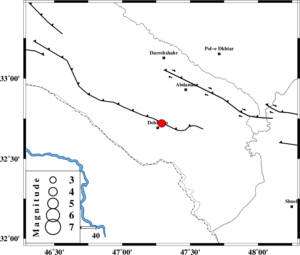
| Location | Lat:32.72 Lon: 47.29 |
| Region | Ilam Province, 4 km Dehloran |
Nearest Cities |
|
| 4 km North of Dehloran, Ilam Province | |
| 20 km North of Musian, Ilam Province | |
| 29 km South West of Abdanan, Ilam Province | |
| 32 km South East of Bishehzar, Ilam Province | |
| 33 km South West of Sarabbagh, Ilam Province | |
| Depth | 14 km |
| Agency | |
Faults within 150 km: |
|
| MFF6 (Length: 144 km) , Distance to epicenter: 5 km | |
| BALARUD_F_Z1 (Length: 87 km) , Distance to epicenter: 37 km | |
| BALARUD_F_Z3 (Length: 53 km) , Distance to epicenter: 73 km | |
| Number of Phases | 7 |
| RMS | 0.2 |
| Number of Stations | 8 |
| Error in Latitude | >4 km |
| Error in Longitude | 8.7 km |
| Error in Depth | 4.7 km |
Download waveform in seisan format
to download seisan software Click here
to access information about IIEES stations Click here
Amplitude | ||||||||
| UID | Agency | Station | Component | Amplitude | Period | Arrival Time | Proccessing Time | Signal Clip |
| 82991 | IIEES | SHGR | N | 4097.6 | 0.51 | 2012-04-22 04:01:44 | 2012-04-22 04:25:00 | n |
| 82992 | IIEES | SHGR | E | 4363.6 | 0.56 | 2012-04-22 04:01:47 | 2012-04-22 04:25:00 | n |
| 82993 | IIEES | KHMZ | N | 163.5 | 0.63 | 2012-04-22 04:02:21 | 2012-04-22 04:25:00 | n |
| 82994 | IIEES | KHMZ | E | 135.1 | 0.68 | 2012-04-22 04:02:28 | 2012-04-22 04:25:00 | n |
| 82995 | IIEES | ASAO | E | 101.8 | 0.7 | 2012-04-22 04:02:37 | 2012-04-22 04:25:00 | n |
| 82996 | IIEES | GHVR | N | 44.4 | 0.7 | 2012-04-22 04:03:07 | 2012-04-22 04:25:00 | n |
| 82997 | IIEES | GHVR | E | 62.5 | 0.7 | 2012-04-22 04:03:11 | 2012-04-22 04:25:00 | n |
Phase | ||||||||||||
| Agency | Station | Component | Phase Type | Phase Quality | First Motion | Observed Arrival Time | Time Residual | Loc. Flag | Input Weight | Distance | Azimuth | |
| IIEES | SHGR | Z | Pg | E | 2012-04-22 04:01:15 | -0.27 | y | 157 | 115 | |||
| IIEES | SNGE | Z | Pn | E | 2012-04-22 04:01:30 | 0.05 | y | 263 | 1 | |||
| IIEES | SNGE | E | Sg | E | 2012-04-22 04:02:04 | -0.18 | y | 263 | 1 | |||
| IIEES | KHMZ | Z | Pn | E | 2012-04-22 04:01:32 | 0.28 | y | 274 | 65 | |||
| IIEES | CHTH | Z | Pn | E | 2012-04-22 04:02:00 | 0.04 | y | 500 | 44 | |||
| IIEES | DAMV | Z | Pn | E | 2012-04-22 04:02:05 | 0.13 | y | 539 | 52 | |||
| IIEES | GRMI | Z | Pn | E | 2012-04-22 04:02:22 | 0.03 | y | 678 | 4 | |||