
Magnitude |
:3.5 |
| Date & Time (UTC) | 2012-04-21 18:58:17.3 |
| Date & Time (Local) | 1391/2/2 23:28:17.3 |
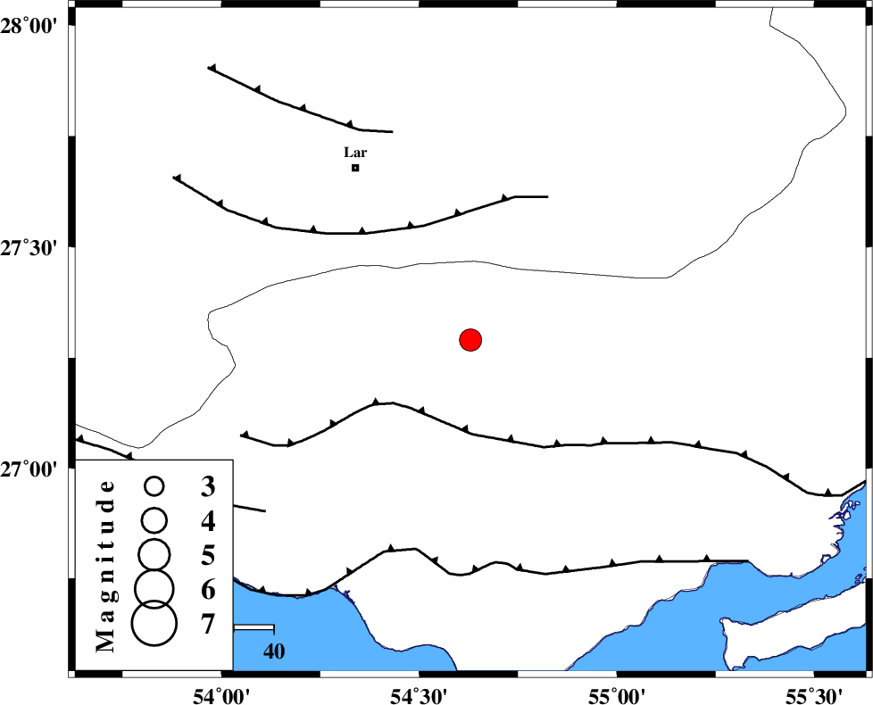
| Location | Lat:27.29 Lon: 54.63 |
| Region | Hormozgan Province, 29 km East of Bastak |
Nearest Cities |
|
| 28 km North East of Bastak, Hormozgan Province | |
| 46 km North East of Jenah, Hormozgan Province | |
| 52 km South East of Latifi, Fars Province | |
| 52 km South East of Lar, Fars Province | |
| 61 km South East of Grash, Fars Province | |
| Depth | 14 km |
| Agency | |
Faults within 150 km: |
|
| MFF1 (Length: 180 km) , Distance to epicenter: 23 km | |
| LAR_F (Length: 99 km) , Distance to epicenter: 31 km | |
| ZFF1 (Length: 165 km) , Distance to epicenter: 54 km | |
| Number of Phases | 4 |
| RMS | 0.1 |
| Number of Stations | 4 |
| Error in Latitude | >6.5 km |
| Error in Longitude | 9.2 km |
| Error in Depth | 18.9 km |
Download waveform in seisan format
to download seisan software Click here
to access information about IIEES stations Click here
Amplitude | ||||||||
| UID | Agency | Station | Component | Amplitude | Period | Arrival Time | Proccessing Time | Signal Clip |
| 82975 | IIEES | BNDS | N | 1061.7 | 0.48 | 2012-04-21 18:59:10 | 2012-04-21 07:40:00 | n |
| 82976 | IIEES | GHIR | E | 569 | 0.36 | 2012-04-21 18:59:16 | 2012-04-21 07:40:00 | n |
| 82977 | IIEES | GHIR | N | 837.2 | 0.44 | 2012-04-21 18:59:20 | 2012-04-21 07:40:00 | n |
| 82978 | IIEES | KRBR | E | 72.9 | 0.6 | 2012-04-21 19:00:08 | 2012-04-21 07:40:00 | n |
| 82979 | IIEES | KRBR | N | 65.1 | 0.48 | 2012-04-21 19:00:09 | 2012-04-21 07:40:00 | n |
Phase | ||||||||||||
| Agency | Station | Component | Phase Type | Phase Quality | First Motion | Observed Arrival Time | Time Residual | Loc. Flag | Input Weight | Distance | Azimuth | |
| IIEES | GHIR | Z | Pg | E | 2012-04-21 18:58:49 | -0.08 | y | 196 | 305 | |||
| IIEES | GHIR | N | Sg | E | 2012-04-21 18:59:13 | 0.06 | y | 196 | 305 | |||
| IIEES | KRBR | Z | Pn | E | 2012-04-21 18:59:10 | -0.01 | y | 364 | 34 | |||
| IIEES | CHBR | Z | Pn | E | 2012-04-21 18:59:41 | 0.06 | y | 613 | 107 | |||