
Magnitude |
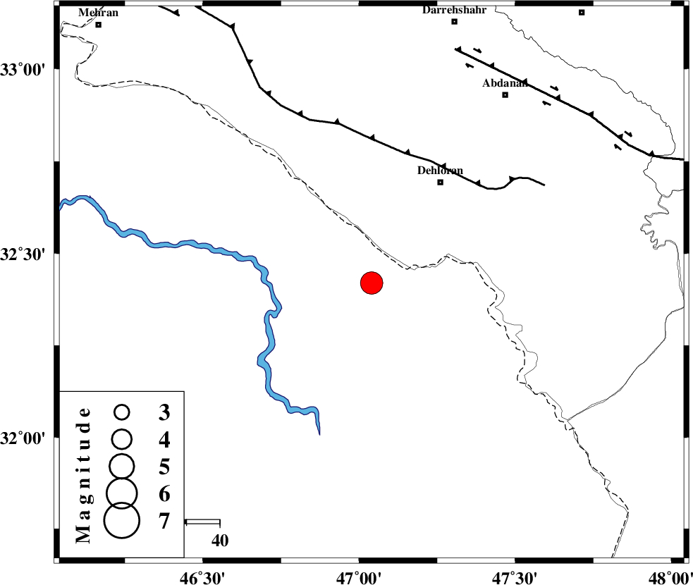
:4.5 |
| Date & Time (UTC) | 2012-04-21 06:13:28.6 |
| Date & Time (Local) | 1391/2/2 10:43:28.6 |
| Location | Lat:32.42 Lon: 47.04 |
| Region | Iraq, 37 km South-West of Dehloran |
Nearest Cities |
|
| 33 km South West of Musian, Ilam Province | |
| 37 km South West of Dehloran, Ilam Province | |
| 45 km South of Bishehzar, Ilam Province | |
| 69 km South West of Abdanan, Ilam Province | |
| 72 km South West of Sarabbagh, Ilam Province | |
| Depth | 38 km |
| Agency | |
Faults within 150 km: |
|
| MFF6 (Length: 144 km) , Distance to epicenter: 40 km | |
| BALARUD_F_Z1 (Length: 87 km) , Distance to epicenter: 75 km | |
| ZFF4 (Length: 128 km) , Distance to epicenter: 99 km | |
| Number of Phases | 7 |
| RMS | 0.1 |
| Number of Stations | 7 |
| Error in Latitude | >3.6 km |
| Error in Longitude | 7 km |
| Error in Depth | 5.4 km |
Download waveform in seisan format
to download seisan software Click here
to access information about IIEES stations Click here
Amplitude | ||||||||
| UID | Agency | Station | Component | Amplitude | Period | Arrival Time | Proccessing Time | Signal Clip |
| 82969 | IIEES | SHGR | E | 7559.1 | 0.5 | 2012-04-21 06:14:21 | 2012-04-21 06:30:00 | n |
| 82970 | IIEES | SHGR | N | 6644.3 | 0.39 | 2012-04-21 06:14:21 | 2012-04-21 06:30:00 | n |
| 82971 | IIEES | SNGE | E | 1294.9 | 0.5 | 2012-04-21 06:14:56 | 2012-04-21 06:30:00 | n |
| 82972 | IIEES | SNGE | N | 1179.1 | 0.57 | 2012-04-21 06:15:01 | 2012-04-21 06:30:00 | n |
| 82973 | IIEES | AHRM | E | 331.6 | 0.33 | 2012-04-21 06:16:28 | 2012-04-21 06:30:00 | n |
| 82974 | IIEES | AHRM | N | 319.3 | 0.58 | 2012-04-21 06:16:34 | 2012-04-21 06:30:00 | n |
Phase | ||||||||||||
| Agency | Station | Component | Phase Type | Phase Quality | First Motion | Observed Arrival Time | Time Residual | Loc. Flag | Input Weight | Distance | Azimuth | |
| IIEES | SHGR | Z | Pg | E | 2012-04-21 06:13:56 | -0.01 | y | 170 | 101 | |||
| IIEES | SNGE | Z | Pn | E | 2012-04-21 06:14:11 | 0.1 | y | 298 | 5 | |||
| IIEES | KHMZ | Z | Pn | E | 2012-04-21 06:14:13 | 0.13 | y | 310 | 61 | |||
| IIEES | ASAO | Z | Pn | E | 2012-04-21 06:14:19 | 0.07 | y | 365 | 49 | |||
| IIEES | THKV | Z | Pn | E | 2012-04-21 06:14:39 | -0.33 | y | 525 | 41 | |||
| IIEES | AHRM | Z | Pn | E | 2012-04-21 06:14:44 | -0.03 | y | 567 | 133 | |||
| IIEES | GRMI | Z | Pn | E | 2012-04-21 06:15:02 | -0.08 | y | 714 | 6 | |||