
Magnitude |
:3.5 |
| Date & Time (UTC) | 2012-04-21 00:55:07.6 |
| Date & Time (Local) | 1391/2/2 05:25:07.6 |
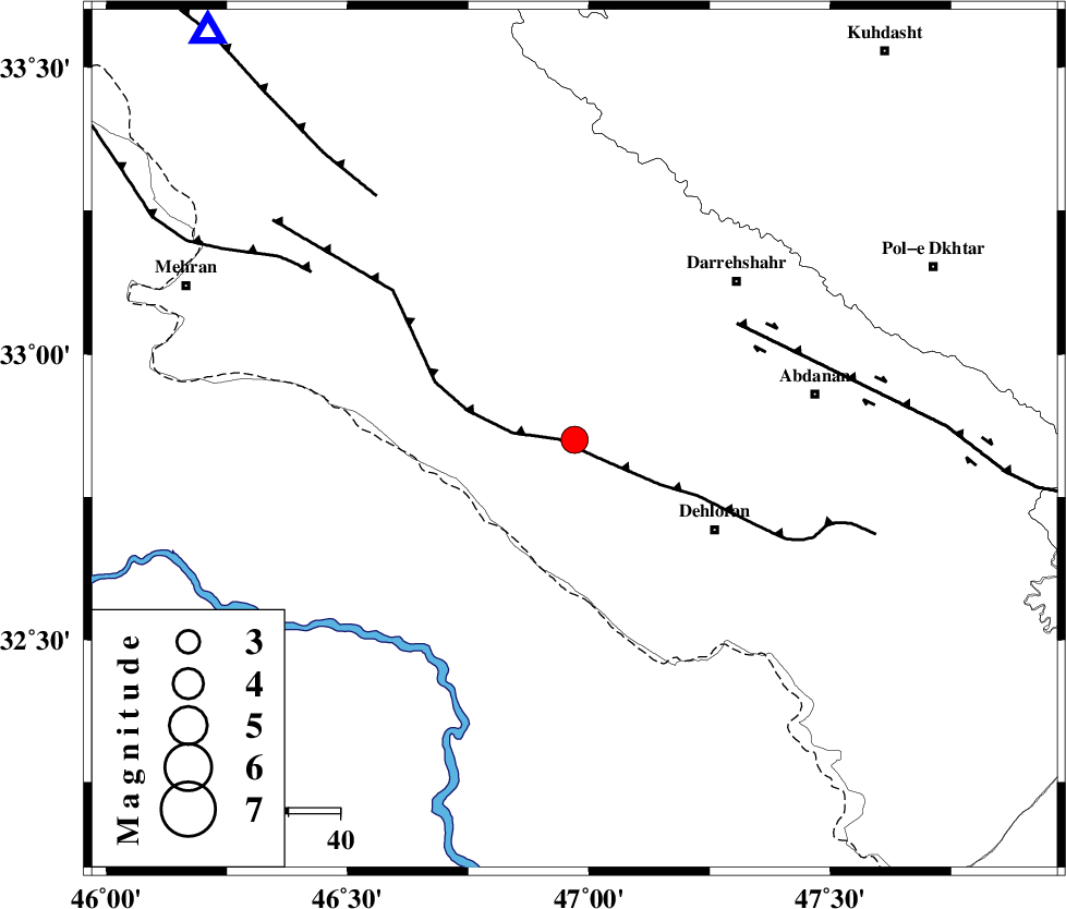
| Location | Lat:32.85 Lon: 46.97 |
| Region | Ilam Province, 32 km North-West of Dehloran |
Nearest Cities |
|
| 3 km North of Bishehzar, Ilam Province | |
| 32 km North West of Dehloran, Ilam Province | |
| 42 km South of Meymeh, Ilam Province | |
| 44 km South West of Darreh Shahr, Ilam Province | |
| 47 km South of Badreh, Ilam Province | |
| Depth | 14 km |
| Agency | |
Faults within 150 km: |
|
| MFF6 (Length: 144 km) , Distance to epicenter: 3 km | |
| BALARUD_F_Z1 (Length: 87 km) , Distance to epicenter: 39 km | |
| ZFF4 (Length: 128 km) , Distance to epicenter: 60 km | |
| Number of Phases | 6 |
| RMS | 0.1 |
| Number of Stations | 4 |
| Error in Latitude | >2.7 km |
| Error in Longitude | 4.5 km |
| Error in Depth | 7.2 km |
Download waveform in seisan format
to download seisan software Click here
to access information about IIEES stations Click here
Amplitude | ||||||||
| UID | Agency | Station | Component | Amplitude | Period | Arrival Time | Proccessing Time | Signal Clip |
| 82939 | IIEES | SHGR | E | 1238 | 0.46 | 2012-04-21 00:56:05 | 2012-04-21 01:13:00 | n |
| 82940 | IIEES | SHGR | N | 1686.3 | 0.6 | 2012-04-21 00:56:05 | 2012-04-21 01:13:00 | n |
| 82941 | IIEES | SNGE | E | 165 | 0.6 | 2012-04-21 00:56:30 | 2012-04-21 01:13:00 | n |
| 82942 | IIEES | SNGE | N | 167.7 | 0.64 | 2012-04-21 00:56:38 | 2012-04-21 01:13:00 | n |
| 82943 | IIEES | KHMZ | N | 136.3 | 0.48 | 2012-04-21 00:56:39 | 2012-04-21 01:13:00 | n |
| 82944 | IIEES | KHMZ | E | 121.6 | 0.56 | 2012-04-21 00:56:50 | 2012-04-21 01:13:00 | n |
| 82945 | IIEES | GHVR | N | 41 | 0.52 | 2012-04-21 00:57:09 | 2012-04-21 01:13:00 | n |
| 82946 | IIEES | GHVR | E | 53.3 | 0.56 | 2012-04-21 00:57:09 | 2012-04-21 01:13:00 | n |
Phase | ||||||||||||
| Agency | Station | Component | Phase Type | Phase Quality | First Motion | Observed Arrival Time | Time Residual | Loc. Flag | Input Weight | Distance | Azimuth | |
| IIEES | SHGR | Z | Pg | E | 2012-04-21 00:55:39 | 0.07 | y | 191 | 115 | |||
| IIEES | SHGR | E | Sg | E | 2012-04-21 00:56:01 | -0.14 | y | 191 | 115 | |||
| IIEES | SNGE | Z | Pn | E | 2012-04-21 00:55:46 | -0.2 | y | 252 | 8 | |||
| IIEES | KHMZ | Z | Pn | E | 2012-04-21 00:55:52 | 0.17 | y | 296 | 70 | |||
| IIEES | KHMZ | N | Sg | E | 2012-04-21 00:56:31 | -0.02 | y | 296 | 70 | |||
| IIEES | GHVR | N | Pn | E | 2012-04-21 00:56:09 | 0.18 | y | 436 | 64 | |||