
Magnitude |
:4.3 |
| Date & Time (UTC) | 2012-04-20 16:32:53.4 |
| Date & Time (Local) | 1391/2/1 21:02:53.4 |
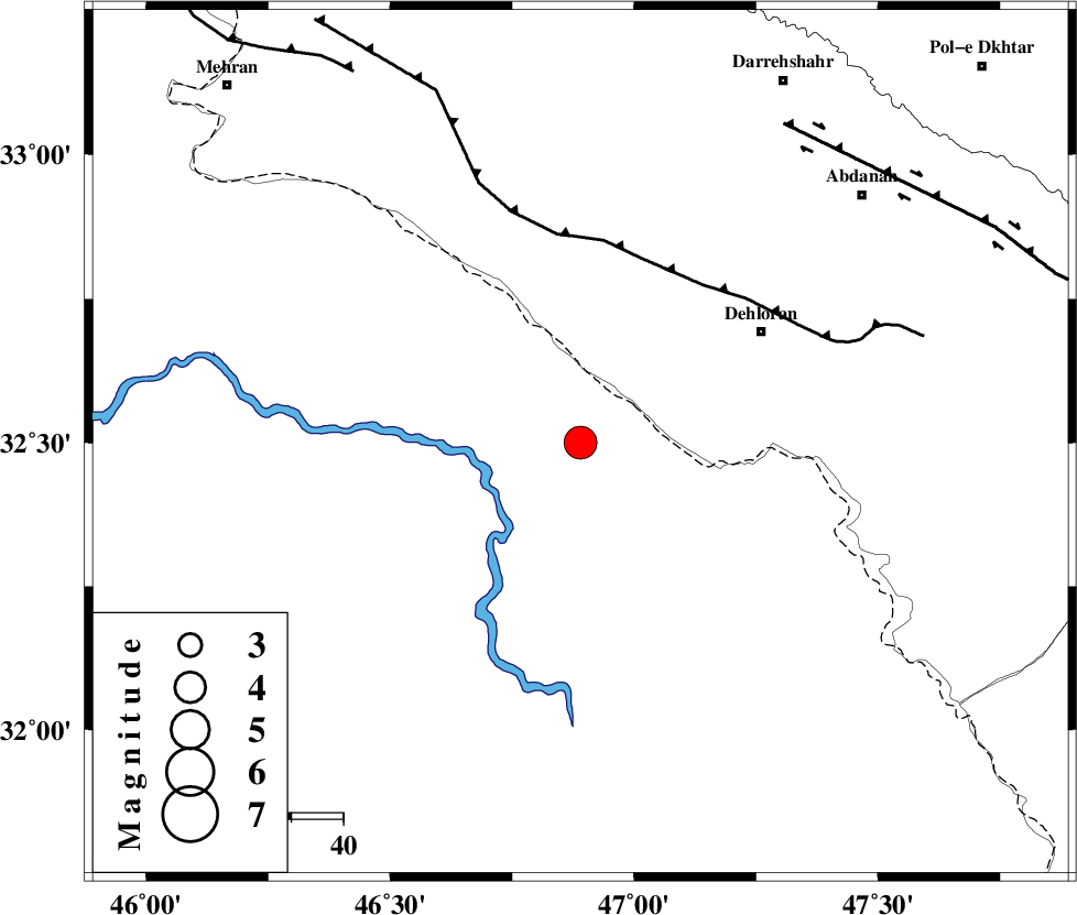
| Location | Lat:32.5 Lon: 46.89 |
| Region | Iraq, 41 km South-West of Dehloran |
Nearest Cities |
|
| 37 km South of Bishehzar, Ilam Province | |
| 41 km South West of Dehloran, Ilam Province | |
| 44 km West of Musian, Ilam Province | |
| 72 km South West of Abdanan, Ilam Province | |
| 77 km South West of Sarabbagh, Ilam Province | |
| Depth | 18 km |
| Agency | |
Faults within 150 km: |
|
| MFF6 (Length: 144 km) , Distance to epicenter: 38 km | |
| BALARUD_F_Z1 (Length: 87 km) , Distance to epicenter: 73 km | |
| ZFF4 (Length: 128 km) , Distance to epicenter: 84 km | |
| Number of Phases | 6 |
| RMS | 0 |
| Number of Stations | 5 |
| Error in Latitude | >2.8 km |
| Error in Longitude | 6.7 km |
| Error in Depth | 3.2 km |
Download waveform in seisan format
to download seisan software Click here
to access information about IIEES stations Click here
Amplitude | ||||||||
| UID | Agency | Station | Component | Amplitude | Period | Arrival Time | Proccessing Time | Signal Clip |
| 82925 | IIEES | SHGR | E | 16000.7 | 0.84 | 2012-04-20 16:33:50 | 2012-04-20 05:04:00 | n |
| 82926 | IIEES | SHGR | N | 7193.1 | 0.52 | 2012-04-20 16:33:51 | 2012-04-20 05:04:00 | n |
| 82927 | IIEES | SNGE | E | 495.3 | 0.52 | 2012-04-20 16:34:23 | 2012-04-20 05:04:00 | n |
| 82928 | IIEES | SNGE | N | 412.6 | 0.6 | 2012-04-20 16:34:25 | 2012-04-20 05:04:00 | n |
| 82929 | IIEES | GHVR | E | 301 | 0.64 | 2012-04-20 16:34:50 | 2012-04-20 05:04:00 | n |
Phase | ||||||||||||
| Agency | Station | Component | Phase Type | Phase Quality | First Motion | Observed Arrival Time | Time Residual | Loc. Flag | Input Weight | Distance | Azimuth | |
| IIEES | SHGR | Z | Pg | E | 2012-04-20 16:33:23 | 0.05 | y | 185 | 103 | |||
| IIEES | SNGE | Z | Pn | E | 2012-04-20 16:33:37 | 0.01 | y | 291 | 8 | |||
| IIEES | SNGE | E | Sg | E | 2012-04-20 16:34:15 | 0.02 | y | 291 | 8 | |||
| IIEES | KHMZ | Z | Pn | E | 2012-04-20 16:33:40 | -0.06 | y | 318 | 64 | |||
| IIEES | ASAO | Z | Pn | E | 2012-04-20 16:33:46 | -0.01 | y | 370 | 51 | |||
| IIEES | GHVR | Z | Pn | E | 2012-04-20 16:33:57 | -0.02 | y | 461 | 60 | |||