
Magnitude |
:3.7 |
| Date & Time (UTC) | 2012-04-20 05:22:33.6 |
| Date & Time (Local) | 1391/2/1 09:52:33.6 |
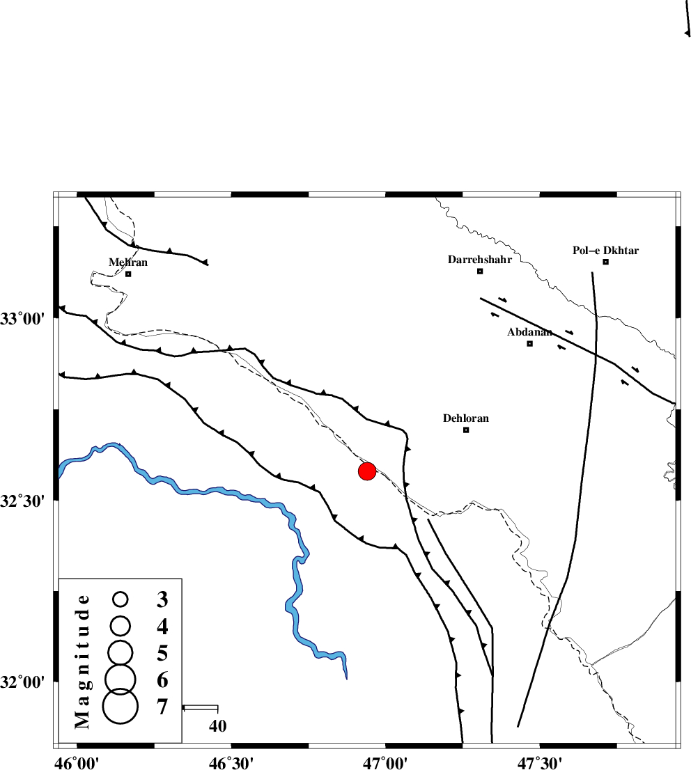
| Location | Lat:32.58 Lon: 46.94 |
| Region | Iraq, 32 km South-West of Dehloran |
Nearest Cities |
|
| 27 km South of Bishehzar, Ilam Province | |
| 32 km South West of Dehloran, Ilam Province | |
| 40 km North West of Musian, Ilam Province | |
| 63 km South West of Abdanan, Ilam Province | |
| 68 km South West of Sarabbagh, Ilam Province | |
| Depth | 17 km |
| Agency | |
Faults within 150 km: |
|
| MFF6 (Length: 144 km) , Distance to epicenter: 28 km | |
| BALARUD_F_Z1 (Length: 87 km) , Distance to epicenter: 63 km | |
| ZFF4 (Length: 128 km) , Distance to epicenter: 79 km | |
| Number of Phases | 6 |
| RMS | 0.1 |
| Number of Stations | 5 |
| Error in Latitude | >4 km |
| Error in Longitude | 9.8 km |
| Error in Depth | 4.6 km |
Download waveform in seisan format
to download seisan software Click here
to access information about IIEES stations Click here
Amplitude | ||||||||
| UID | Agency | Station | Component | Amplitude | Period | Arrival Time | Proccessing Time | Signal Clip |
| 82903 | IIEES | SHGR | E | 1317.4 | 0.44 | 2012-04-20 05:23:29 | 2012-04-20 05:55:00 | n |
| 82904 | IIEES | SHGR | N | 1080.1 | 0.64 | 2012-04-20 05:23:31 | 2012-04-20 05:55:00 | n |
| 82905 | IIEES | SNGE | E | 171.4 | 0.76 | 2012-04-20 05:24:00 | 2012-04-20 05:55:00 | n |
Phase | ||||||||||||
| Agency | Station | Component | Phase Type | Phase Quality | First Motion | Observed Arrival Time | Time Residual | Loc. Flag | Input Weight | Distance | Azimuth | |
| IIEES | SHGR | Z | Pg | E | 2012-04-20 05:23:03 | 0.01 | y | 183 | 106 | |||
| IIEES | SNGE | Z | Pn | E | 2012-04-20 05:23:16 | -0.02 | y | 281 | 8 | |||
| IIEES | SNGE | E | Sg | E | 2012-04-20 05:23:52 | -0.01 | y | 281 | 8 | |||
| IIEES | KHMZ | Z | Pn | E | 2012-04-20 05:23:19 | -0.23 | y | 310 | 65 | |||
| IIEES | ASAO | Z | Pn | E | 2012-04-20 05:23:26 | 0.29 | y | 360 | 52 | |||
| IIEES | GHVR | Z | Pn | E | 2012-04-20 05:23:37 | -0.02 | y | 452 | 61 | |||