
Magnitude |
:3.3 |
| Date & Time (UTC) | 2012-04-18 19:00:07.5 |
| Date & Time (Local) | 1391/1/30 23:30:07.5 |
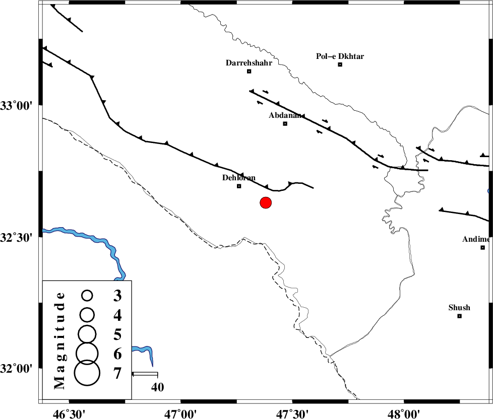
| Location | Lat:32.63 Lon: 47.38 |
| Region | Ilam Province, 13 km East of Dehloran |
Nearest Cities |
|
| 10 km North of Musian, Ilam Province | |
| 13 km East of Dehloran, Ilam Province | |
| 34 km South of Abdanan, Ilam Province | |
| 35 km South West of Sarabbagh, Ilam Province | |
| 44 km South East of Bishehzar, Ilam Province | |
| Depth | 18 km |
| Agency | |
Faults within 150 km: |
|
| MFF6 (Length: 144 km) , Distance to epicenter: 6 km | |
| BALARUD_F_Z1 (Length: 87 km) , Distance to epicenter: 43 km | |
| BALARUD_F_Z3 (Length: 53 km) , Distance to epicenter: 67 km | |
| Number of Phases | 5 |
| RMS | 0 |
| Number of Stations | 4 |
| Error in Latitude | >2.4 km |
| Error in Longitude | 3.6 km |
| Error in Depth | 5.2 km |
Download waveform in seisan format
to download seisan software Click here
to access information about IIEES stations Click here
Amplitude | ||||||||
| UID | Agency | Station | Component | Amplitude | Period | Arrival Time | Proccessing Time | Signal Clip |
| 82805 | IIEES | SHGR | E | 464.6 | 0.48 | 2012-04-18 19:00:57 | 2012-04-18 07:17:00 | n |
| 82806 | IIEES | SHGR | N | 571.1 | 0.76 | 2012-04-18 19:00:57 | 2012-04-18 07:17:00 | n |
| 82807 | IIEES | SNGE | E | 173.5 | 0.52 | 2012-04-18 19:01:31 | 2012-04-18 07:17:00 | n |
| 82808 | IIEES | SNGE | N | 186.7 | 0.68 | 2012-04-18 19:01:34 | 2012-04-18 07:17:00 | n |
Phase | ||||||||||||
| Agency | Station | Component | Phase Type | Phase Quality | First Motion | Observed Arrival Time | Time Residual | Loc. Flag | Input Weight | Distance | Azimuth | |
| IIEES | SHGR | Z | Pg | E | 2012-04-18 19:00:31 | 0 | y | 146 | 113 | |||
| IIEES | KHMZ | Z | Pn | E | 2012-04-18 19:00:48 | -0.01 | y | 271 | 62 | |||
| IIEES | KHMZ | N | Sg | E | 2012-04-18 19:01:23 | 0 | y | 271 | 62 | |||
| IIEES | SNGE | Z | Pn | E | 2012-04-18 19:00:48 | 0 | y | 273 | 359 | |||
| IIEES | ASAO | Z | Pn | E | 2012-04-18 19:00:55 | 0.02 | y | 325 | 48 | |||