
Magnitude |
:5.1 |
| Date & Time (UTC) | 2012-04-18 17:40:36.2 |
| Date & Time (Local) | 1391/1/30 22:10:36.2 |
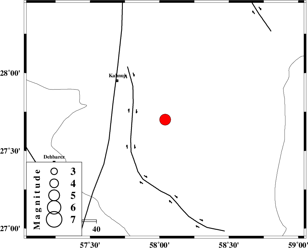
| Location | Lat:27.7 Lon: 58.04 |
| Region | Kerman Province, 44 km South-East of Kahnuj |
Nearest Cities |
|
| 25 km North East of Qalehy-eganj, Kerman Province | |
| 38 km North East of Bargah, Kerman Province | |
| 44 km South East of Kahnuj, Kerman Province | |
| 58 km North East of Bejogan, Kerman Province | |
| 59 km South West of Borj-e abbasabad, Kerman Province | |
| Depth | 15 km |
| Agency | |
Faults within 150 km: |
|
| JIROFT_F (Length: 144 km) , Distance to epicenter: 24 km | |
| SABZEVARAN_F (Length: 190 km) , Distance to epicenter: 39 km | |
| ZENDAN_MINAB_F_Z1 (Length: 183 km) , Distance to epicenter: 95 km | |
| Number of Phases | 5 |
| RMS | 0.5 |
| Number of Stations | 6 |
| Error in Latitude | >5.9 km |
| Error in Longitude | 3.4 km |
| Error in Depth | 0 km |
Download waveform in seisan format
to download seisan software Click here
to access information about IIEES stations Click here
Amplitude | ||||||||
| UID | Agency | Station | Component | Amplitude | Period | Arrival Time | Proccessing Time | Signal Clip |
| 82794 | IIEES | CHBR | N | 4792.6 | 0.68 | 2012-04-18 17:42:02 | 2012-04-18 06:10:00 | n |
| 82795 | IIEES | CHBR | E | 3709.1 | 0.32 | 2012-04-18 17:42:04 | 2012-04-18 06:10:00 | n |
| 82796 | IIEES | GHIR | E | 1396.1 | 0.28 | 2012-04-18 17:42:39 | 2012-04-18 06:10:00 | n |
| 82797 | IIEES | GHIR | N | 2081.1 | 0.52 | 2012-04-18 17:42:43 | 2012-04-18 06:10:00 | n |
| 82798 | IIEES | TABS | E | 105.1 | 0.44 | 2012-04-18 17:42:49 | 2012-04-18 06:10:00 | n |
| 82799 | IIEES | AHRM | N | 2605.9 | 0.52 | 2012-04-18 17:43:12 | 2012-04-18 06:10:00 | n |
| 82800 | IIEES | AHRM | E | 1628.8 | 0.68 | 2012-04-18 17:43:13 | 2012-04-18 06:10:00 | n |
Phase | ||||||||||||
| Agency | Station | Component | Phase Type | Phase Quality | First Motion | Observed Arrival Time | Time Residual | Loc. Flag | Input Weight | Distance | Azimuth | |
| IIEES | KRBR | Z | Pn | E | 2012-04-18 17:41:19 | 0.6 | y | 282 | 334 | |||
| IIEES | CHBR | Z | Pn | E | 2012-04-18 17:41:25 | 0.07 | y | 337 | 133 | |||
| IIEES | ZHSF | Z | Pn | E | 2012-04-18 17:41:26 | -0.03 | y | 341 | 51 | |||
| IIEES | GHIR | Z | Pn | E | 2012-04-18 17:41:45 | -0.28 | y | 501 | 279 | |||
| IIEES | TABS | Z | Pn | E | 2012-04-18 17:42:05 | -0.89 | y | 666 | 353 | |||