
Magnitude |
:3 |
| Date & Time (UTC) | 2012-04-13 06:03:27.1 |
| Date & Time (Local) | 1391/1/25 10:33:27.1 |
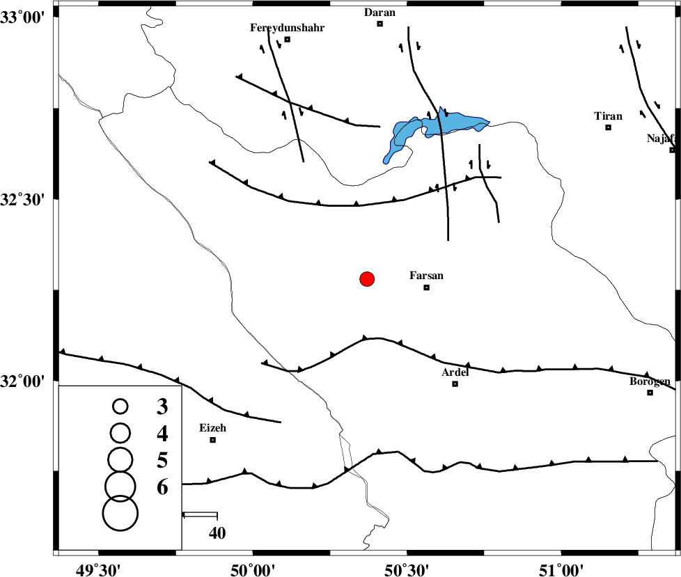
| Location | Lat:32.28 Lon: 50.37 |
| Region | Chaharmahal Bakhtiari Province, 18 km West of Farsan |
Nearest Cities |
|
| 12 km West of Babaheydar, Chaharmahal Bakhtiari Province | |
| 18 km North West of Farsan, Chaharmahal Bakhtiari Province | |
| 22 km South West of Haruni, Chaharmahal Bakhtiari Province | |
| 25 km North West of Chelicheh, Chaharmahal Bakhtiari Province | |
| 27 km North West of Rostamabad, Chaharmahal Bakhtiari Province | |
| Depth | 14 km |
| Agency | |
Faults within 150 km: |
|
| ARDAL_F (Length: 170 km) , Distance to epicenter: 2 km | |
| MAIN_ZAGROS_R_F (Length: 1106 km) , Distance to epicenter: 17 km | |
| ZARDKUH_F (Length: 139 km) , Distance to epicenter: 21 km | |
| Number of Phases | 6 |
| RMS | 0 |
| Number of Stations | 5 |
| Error in Latitude | >2.2 km |
| Error in Longitude | 5.2 km |
| Error in Depth | 5.6 km |
Download waveform in seisan format
to download seisan software Click here
to access information about IIEES stations Click here
Amplitude | ||||||||
| UID | Agency | Station | Component | Amplitude | Period | Arrival Time | Proccessing Time | Signal Clip |
| 82745 | IIEES | SHGR | N | 242 | 0.32 | 2012-04-13 06:04:20 | 2012-04-13 06:42:00 | n |
Phase | ||||||||||||
| Agency | Station | Component | Phase Type | Phase Quality | First Motion | Observed Arrival Time | Time Residual | Loc. Flag | Input Weight | Distance | Azimuth | |
| IIEES | SHGR | Z | Pg | E | 2012-04-13 06:03:51 | -0.02 | y | 149 | 263 | |||
| IIEES | KHMZ | Z | Pg | E | 2012-04-13 06:03:54 | 0.02 | y | 166 | 347 | |||
| IIEES | KHMZ | E | Sg | E | 2012-04-13 06:04:14 | -0.03 | y | 166 | 347 | |||
| IIEES | ASAO | Z | Pn | E | 2012-04-13 06:04:06 | 0.09 | y | 253 | 353 | |||
| IIEES | GHVR | Z | Pn | E | 2012-04-13 06:04:06 | -0.04 | y | 257 | 18 | |||
| IIEES | DAMV | Z | Pn | E | 2012-04-13 06:04:24 | -0.03 | y | 400 | 21 | |||