
Magnitude |
:1.6 |
| Date & Time (UTC) | 2012-04-08 08:37:22.3 |
| Date & Time (Local) | 1391/1/20 13:07:22.3 |
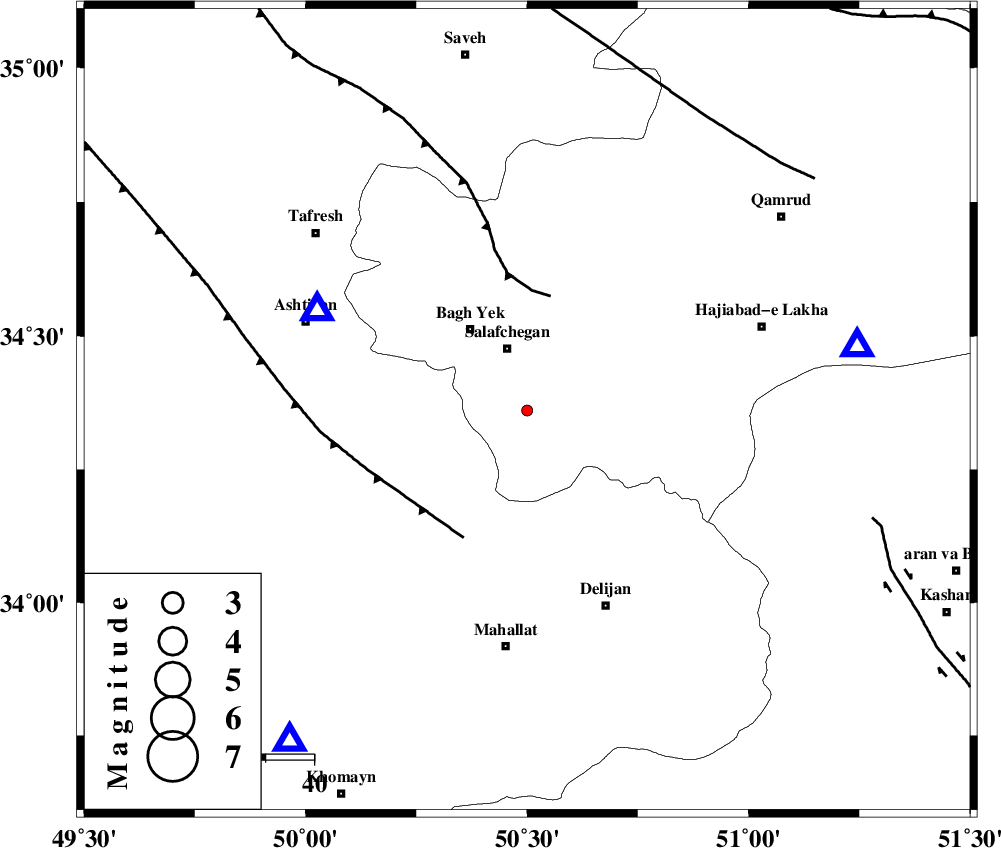
| Location | Lat:34.36 Lon: 50.5 |
| Region | Qom Province, 49 km North of Mahallat |
Nearest Cities |
|
| 14 km South of Salafchegan, Qom Province | |
| 21 km South East of Bagh yek, Qom Province | |
| 26 km North of Dudhak, Markazi Province | |
| 27 km East of Salehabad, Markazi Province | |
| 31 km South East of Dastjerd, Qom Province | |
| Depth | 15 km |
| Agency | |
Faults within 150 km: |
|
| INDES_F (Length: 98 km) , Distance to epicenter: 24 km | |
| TAFRESH_F (Length: 117 km) , Distance to epicenter: 30 km | |
| KUSHK_E_NOSRAT_F (Length: 230 km) , Distance to epicenter: 71 km | |
| Number of Phases | 6 |
| RMS | 0.7 |
| Number of Stations | 6 |
| Error in Latitude | >7.3 km |
| Error in Longitude | 7.4 km |
| Error in Depth | 15.9 km |
Download waveform in seisan format
to download seisan software Click here
to access information about IIEES stations Click here
Amplitude | ||||||||
| UID | Agency | Station | Component | Amplitude | Period | Arrival Time | Proccessing Time | Signal Clip |
| 82675 | IIEES | ASAO | E | 35.2 | 0.41 | 2012-04-08 08:37:43 | 2012-04-08 09:48:00 | n |
| 82676 | IIEES | GHVR | E | 39.9 | 0.22 | 2012-04-08 08:37:47 | 2012-04-08 09:48:00 | n |
| 82677 | IIEES | GHVR | N | 22.3 | 0.38 | 2012-04-08 08:37:51 | 2012-04-08 09:48:00 | n |
| 82678 | IIEES | KHMZ | N | 26.7 | 0.36 | 2012-04-08 08:37:50 | 2012-04-08 09:48:00 | n |
Phase | ||||||||||||
| Agency | Station | Component | Phase Type | Phase Quality | First Motion | Observed Arrival Time | Time Residual | Loc. Flag | Input Weight | Distance | Azimuth | |
| IIEES | ASAO | Z | Pg | E | 2012-04-08 08:37:31 | 0.29 | y | 48.3 | 296 | |||
| IIEES | GHVR | Z | Pg | E | 2012-04-08 08:37:34 | -0.42 | y | 69.7 | 79 | |||
| IIEES | KHMZ | Z | Pg | E | 2012-04-08 08:37:36 | -0.66 | y | 84.8 | 216 | |||
| IIEES | CHTH | Z | Pg | E | 2012-04-08 08:37:52 | 0.48 | y | 181 | 18 | |||
| IIEES | DAMV | Z | Pg | E | 2012-04-08 08:37:53 | -0.73 | y | 195 | 43 | |||
| IIEES | NASN | Z | Pn | E | 2012-04-08 08:38:05 | 1.1 | y | 275 | 128 | |||