
Magnitude |
:2.7 |
| Date & Time (UTC) | 2012-03-28 15:26:14.2 |
| Date & Time (Local) | 1391/1/9 19:56:14.2 |
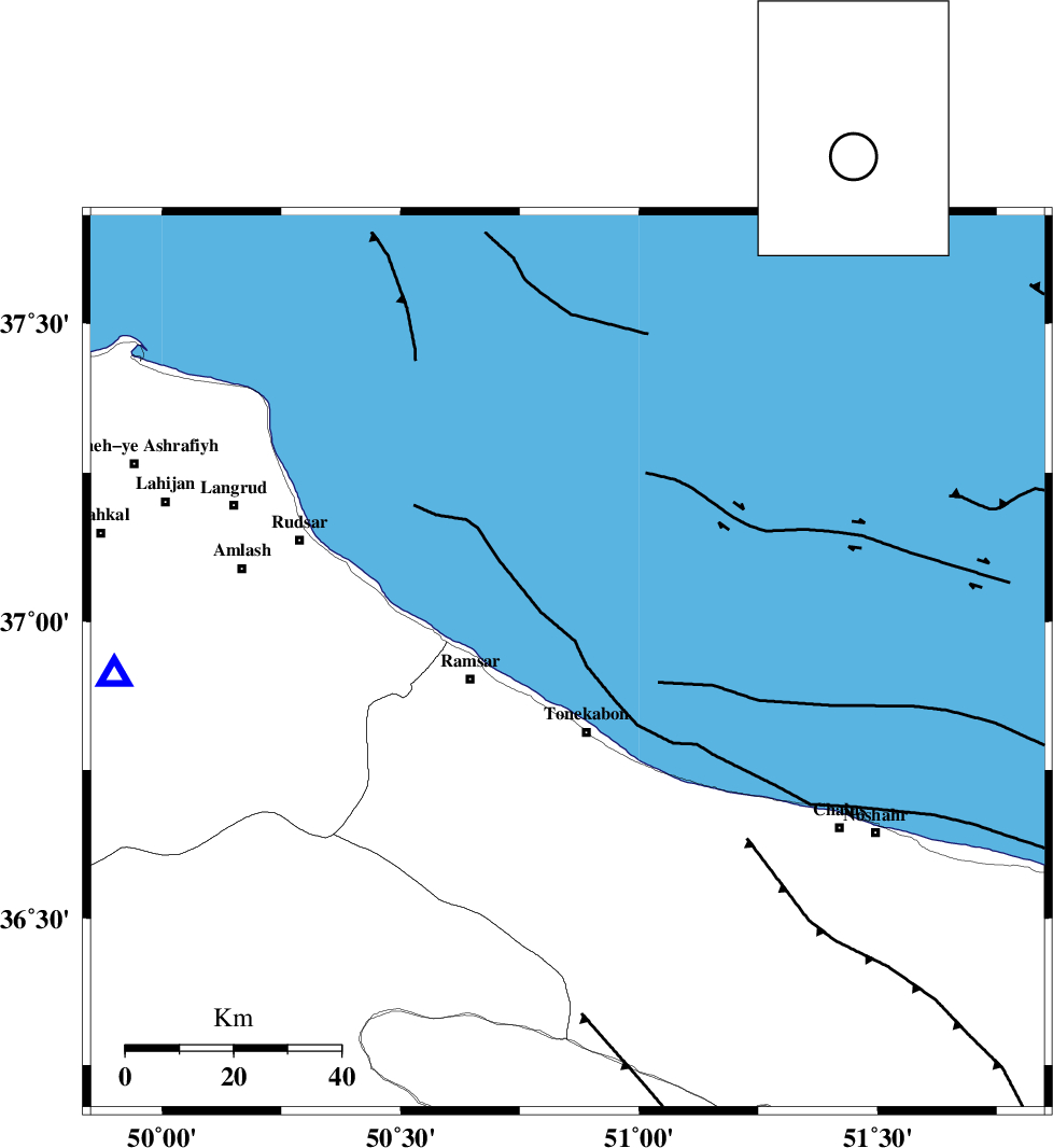
| Location | Lat:36.93 Lon: 50.85 |
| Region | Caspian Sea, 14 km North of Tonekabon |
Nearest Cities |
|
| 13 km North of Tonekabon, Mazandaran Province | |
| 15 km North of Soleymanabad, Mazandaran Province | |
| 16 km North of Khorramabad, Mazandaran Province | |
| 18 km North East of Ramsar, Mazandaran Province | |
| 20 km East of Galesh mahalleh, Mazandaran Province | |
| Depth | 14 km |
| Agency | |
Faults within 150 km: |
|
| KHAZAR_F (Length: 523 km) , Distance to epicenter: 16 km | |
| N_ALBORZ_F (Length: 360 km) , Distance to epicenter: 28 km | |
| BONAN_F (Length: 74 km) , Distance to epicenter: 43 km | |
| Number of Phases | 7 |
| RMS | 0.1 |
| Number of Stations | 5 |
| Error in Latitude | >2.9 km |
| Error in Longitude | 2.5 km |
| Error in Depth | 3.9 km |
Download waveform in seisan format
to download seisan software Click here
to access information about IIEES stations Click here
Amplitude | ||||||||
| UID | Agency | Station | Component | Amplitude | Period | Arrival Time | Proccessing Time | Signal Clip |
| 82580 | IIEES | THKV | E | 186.4 | 0.36 | 2012-03-28 15:26:48 | 2012-03-28 05:16:00 | n |
Phase | ||||||||||||
| Agency | Station | Component | Phase Type | Phase Quality | First Motion | Observed Arrival Time | Time Residual | Loc. Flag | Input Weight | Distance | Azimuth | |
| IIEES | THKV | Z | Pg | E | 2012-03-28 15:26:33 | 0.01 | y | 113 | 179 | |||
| IIEES | THKV | E | Sg | E | 2012-03-28 15:26:47 | -0.02 | y | 113 | 179 | |||
| IIEES | DAMV | Z | Pn | E | 2012-03-28 15:26:44 | 0.01 | y | 176 | 145 | |||
| IIEES | ZNJK | Z | Pn | E | 2012-03-28 15:26:46 | -0.08 | y | 195 | 262 | |||
| IIEES | ZNJK | N | Sg | E | 2012-03-28 15:27:09 | 0.01 | y | 195 | 262 | |||
| IIEES | ASAO | Z | Pn | E | 2012-03-28 15:26:56 | -0.02 | y | 275 | 196 | |||
| IIEES | SNGE | Z | Pn | E | 2012-03-28 15:27:08 | 0.11 | y | 376 | 238 | |||