
Magnitude |
:3.4 |
| Date & Time (UTC) | 2012-03-27 00:49:29.4 |
| Date & Time (Local) | 1391/1/8 05:19:29.4 |
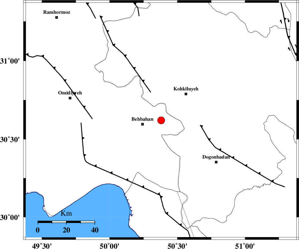
| Location | Lat:30.62 Lon: 50.38 |
| Region | Khoozestan Province, 14 km East of Behbahan |
Nearest Cities |
|
| 8 km of Mansuriyeh, Khoozestan Province | |
| 13 km North East of Behbahan, Khoozestan Province | |
| 22 km East of Dodange-ye bozorg, Khoozestan Province | |
| 26 km South West of Dehdasht, Kohkiluieh va boyerahmad Province | |
| 37 km North East of Sardasht, Khoozestan Province | |
| Depth | 15 km |
| Agency | |
Faults within 150 km: |
|
| MFF4 (Length: 62 km) , Distance to epicenter: 21 km | |
| MISHAN_F (Length: 76 km) , Distance to epicenter: 28 km | |
| AGHAJARI_F (Length: 88 km) , Distance to epicenter: 49 km | |
| Number of Phases | 6 |
| RMS | 0.1 |
| Number of Stations | 6 |
| Error in Latitude | >1.7 km |
| Error in Longitude | 1.3 km |
| Error in Depth | 0 km |
Download waveform in seisan format
to download seisan software Click here
to access information about IIEES stations Click here
Amplitude | ||||||||
| UID | Agency | Station | Component | Amplitude | Period | Arrival Time | Proccessing Time | Signal Clip |
| 82556 | IIEES | AHRM | E | 302.1 | 0.52 | 2012-03-27 00:50:35 | 2012-03-27 01:09:00 | n |
| 82557 | IIEES | AHRM | N | 230.8 | 0.48 | 2012-03-27 00:50:39 | 2012-03-27 01:09:00 | n |
| 82558 | IIEES | SHGR | E | 339.8 | 0.52 | 2012-03-27 00:50:39 | 2012-03-27 01:09:00 | n |
| 82559 | IIEES | SHGR | N | 378.5 | 0.52 | 2012-03-27 00:50:46 | 2012-03-27 01:09:00 | n |
| 82560 | IIEES | GHIR | E | 60.7 | 0.44 | 2012-03-27 00:51:33 | 2012-03-27 01:09:00 | n |
| 82561 | IIEES | GHIR | N | 70.4 | 0.56 | 2012-03-27 00:51:33 | 2012-03-27 01:09:00 | n |
Phase | ||||||||||||
| Agency | Station | Component | Phase Type | Phase Quality | First Motion | Observed Arrival Time | Time Residual | Loc. Flag | Input Weight | Distance | Azimuth | |
| IIEES | AHRM | Z | Pn | E | 2012-03-27 00:50:03 | 0.13 | y | 214 | 155 | |||
| IIEES | SHGR | Z | Pn | E | 2012-03-27 00:50:04 | -0.08 | y | 223 | 318 | |||
| IIEES | NASN | Z | Pn | E | 2012-03-27 00:50:18 | -0.01 | y | 333 | 43 | |||
| IIEES | KHMZ | Z | Pn | E | 2012-03-27 00:50:20 | 0.11 | y | 348 | 354 | |||
| IIEES | GHIR | Z | Pn | E | 2012-03-27 00:50:21 | -0.16 | y | 362 | 135 | |||
| IIEES | KRBR | Z | Pn | E | 2012-03-27 00:50:54 | 0 | y | 618 | 95 | |||