
Magnitude |
:2.1 |
| Date & Time (UTC) | 2012-03-23 20:55:55.4 |
| Date & Time (Local) | 1391/1/5 01:25:55.4 |
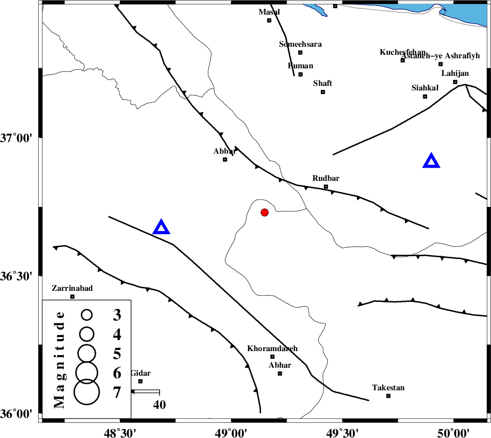
| Location | Lat:36.73 Lon: 49.15 |
| Region | Ghazvin Province, 27 km West of Rudbar |
Nearest Cities |
|
| 10 km North of Sirdan, Ghazvin Province | |
| 19 km North West of Siyahpush, Ghazvin Province | |
| 21 km South East of Void, Zanjan Province | |
| 22 km West of Manjil, Gilan Province | |
| 24 km East of Chorzag, Zanjan Province | |
| Depth | 18 km |
| Agency | |
Faults within 150 km: |
|
| RUDBAR_F (Length: 93 km) , Distance to epicenter: 15 km | |
| MASULEL_F (Length: 90 km) , Distance to epicenter: 26 km | |
| ZANJAN_F (Length: 137 km) , Distance to epicenter: 35 km | |
| Number of Phases | 5 |
| RMS | 0.1 |
| Number of Stations | 3 |
| Error in Latitude | >13.9 km |
| Error in Longitude | 4.9 km |
| Error in Depth | 6.1 km |
Download waveform in seisan format
to download seisan software Click here
to access information about IIEES stations Click here
Amplitude | ||||||||
| UID | Agency | Station | Component | Amplitude | Period | Arrival Time | Proccessing Time | Signal Clip |
| 82518 | IIEES | ZNJK | N | 228.8 | 0.08 | 2012-03-23 20:56:09 | 2012-03-24 01:53:00 | n |
| 82519 | IIEES | ZNJK | E | 135.9 | 0.32 | 2012-03-23 20:56:09 | 2012-03-24 01:53:00 | n |
| 82520 | IIEES | THKV | E | 24.2 | 0.4 | 2012-03-23 20:56:47 | 2012-03-24 01:53:00 | n |
| 82521 | IIEES | THKV | N | 17.1 | 0.16 | 2012-03-23 20:56:49 | 2012-03-24 01:53:00 | n |
Phase | ||||||||||||
| Agency | Station | Component | Phase Type | Phase Quality | First Motion | Observed Arrival Time | Time Residual | Loc. Flag | Input Weight | Distance | Azimuth | |
| IIEES | ZNJK | Z | Pg | E | 2012-03-23 20:56:03 | 0.07 | y | 42.3 | 262 | |||
| IIEES | ZNJK | E | Sg | E | 2012-03-23 20:56:09 | -0.04 | y | 42.3 | 262 | |||
| IIEES | THKV | Z | Pn | E | 2012-03-23 20:56:25 | 0.06 | y | 179 | 120 | |||
| IIEES | THKV | E | Sg | E | 2012-03-23 20:56:46 | 0.01 | y | 179 | 120 | |||
| IIEES | CHTH | Z | Pn | E | 2012-03-23 20:56:27 | -0.1 | y | 199 | 117 | |||