
Magnitude |
:2.8 |
| Date & Time (UTC) | 2012-03-22 19:02:06.6 |
| Date & Time (Local) | 1391/1/3 23:32:06.6 |
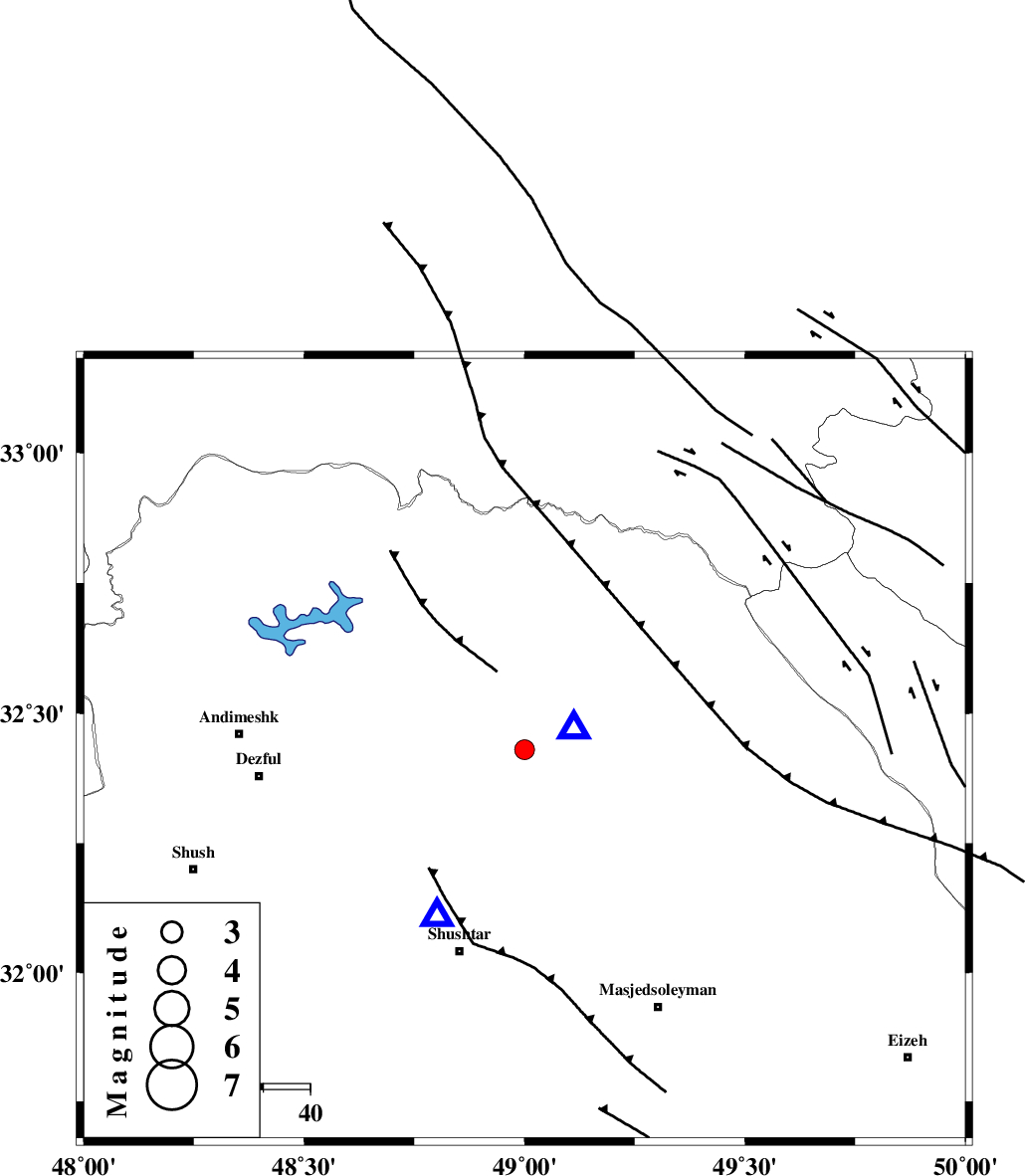
| Location | Lat:32.43 Lon: 49 |
| Region | Khoozestan Province, 11 km West of Lali |
Nearest Cities |
|
| 11 km North West of Lali, Khoozestan Province | |
| 17 km East of Sardasht, Khoozestan Province | |
| 21 km North West of Jaefarabad, Khoozestan Province | |
| 27 km North East of Gatvand, Khoozestan Province | |
| 29 km North East of Samaleh, Khoozestan Province | |
| Depth | 25 km |
| Agency | |
Faults within 150 km: |
|
| DEZFUL_EMBAYMENT (Length: 228 km) , Distance to epicenter: 21 km | |
| MFF2 (Length: 205 km) , Distance to epicenter: 22 km | |
| BALARUD_F_Z2 (Length: 58 km) , Distance to epicenter: 31 km | |
| Number of Phases | 6 |
| RMS | 0.1 |
| Number of Stations | 5 |
| Error in Latitude | >1.7 km |
| Error in Longitude | 2.6 km |
| Error in Depth | 2.4 km |
Download waveform in seisan format
to download seisan software Click here
to access information about IIEES stations Click here
Amplitude | ||||||||
| UID | Agency | Station | Component | Amplitude | Period | Arrival Time | Proccessing Time | Signal Clip |
| 82481 | IIEES | SHGR | N | 2212.9 | 0.4 | 2012-03-22 19:02:28 | 2012-03-22 06:13:00 | n |
| 82482 | IIEES | SHGR | E | 972.9 | 0.32 | 2012-03-22 19:02:31 | 2012-03-22 06:13:00 | n |
| 82483 | IIEES | KHMZ | E | 119.7 | 0.52 | 2012-03-22 19:02:57 | 2012-03-22 06:13:00 | n |
| 82484 | IIEES | KHMZ | N | 93.5 | 0.44 | 2012-03-22 19:02:59 | 2012-03-22 06:13:00 | n |
| 82485 | IIEES | ASAO | N | 41.8 | 0.6 | 2012-03-22 19:03:23 | 2012-03-22 06:13:00 | n |
| 82486 | IIEES | ASAO | E | 54.1 | 0.52 | 2012-03-22 19:03:24 | 2012-03-22 06:13:00 | n |
Phase | ||||||||||||
| Agency | Station | Component | Phase Type | Phase Quality | First Motion | Observed Arrival Time | Time Residual | Loc. Flag | Input Weight | Distance | Azimuth | |
| IIEES | SHGR | Z | Pg | E | 2012-03-22 19:02:14 | -0.01 | y | 40.4 | 208 | |||
| IIEES | KHMZ | Z | Pn | E | 2012-03-22 19:02:34 | -0.12 | y | 171 | 32 | |||
| IIEES | KHMZ | N | Sg | E | 2012-03-22 19:02:54 | 0.02 | y | 171 | 32 | |||
| IIEES | ASAO | Z | Pn | E | 2012-03-22 19:02:45 | -0.02 | y | 253 | 22 | |||
| IIEES | SNGE | Z | Pn | E | 2012-03-22 19:02:54 | 0.07 | y | 333 | 333 | |||
| IIEES | NASN | Z | Pn | E | 2012-03-22 19:02:58 | 0.08 | y | 360 | 82 | |||