
Magnitude |
:2.6 |
| Date & Time (UTC) | 2012-03-22 17:46:15.3 |
| Date & Time (Local) | 1391/1/3 22:16:15.3 |
| Location | Lat:34.45 Lon: 49.7 |
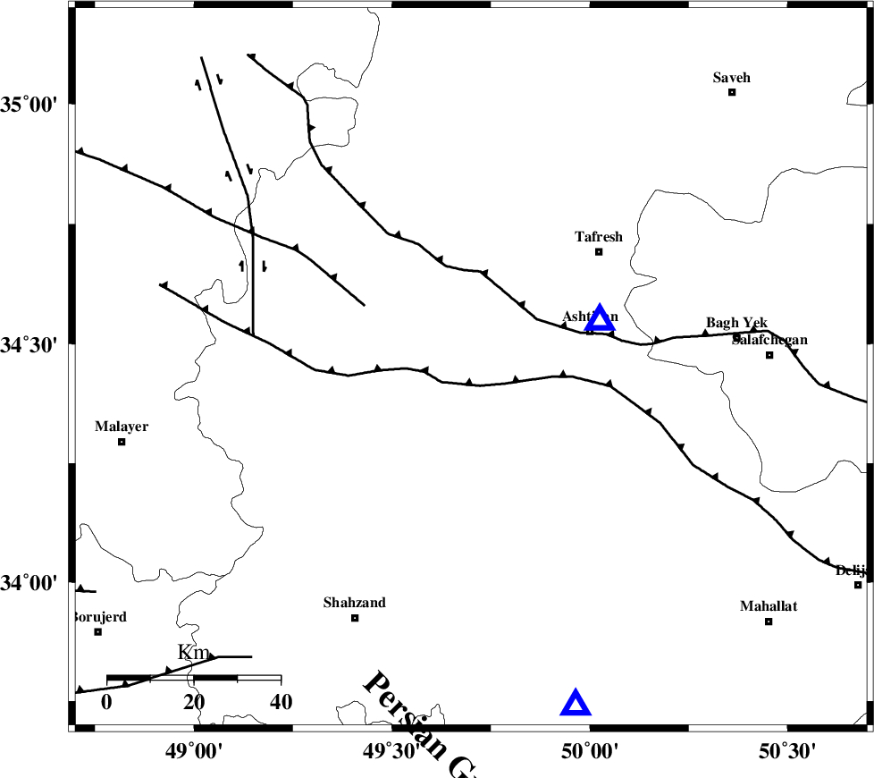
| Region | Markazi Province, 40 km North of Arak |
Nearest Cities |
|
| 7 km of Farmahin, Markazi Province | |
| 18 km North East of Saruq, Markazi Province | |
| 22 km North of Ebakabad, Markazi Province | |
| 23 km North West of Davoodabad, Markazi Province | |
| 24 km South West of Shahrab, Markazi Province | |
| Depth | 12 km |
| Agency | |
Faults within 150 km: |
|
| TAFRESH_F (Length: 117 km) , Distance to epicenter: 16 km | |
| INDES_F (Length: 98 km) , Distance to epicenter: 68 km | |
| KUSHK_E_NOSRAT_F (Length: 230 km) , Distance to epicenter: 91 km | |
| Number of Phases | 6 |
| RMS | 0.2 |
| Number of Stations | 6 |
| Error in Latitude | >3.5 km |
| Error in Longitude | 4.3 km |
| Error in Depth | 5.6 km |
Download waveform in seisan format
to download seisan software Click here
to access information about IIEES stations Click here
Amplitude | ||||||||
| UID | Agency | Station | Component | Amplitude | Period | Arrival Time | Proccessing Time | Signal Clip |
| 82470 | IIEES | KHMZ | E | 203.7 | 0.28 | 2012-03-22 17:46:42 | 2012-03-22 05:17:00 | n |
| 82471 | IIEES | KHMZ | N | 177.2 | 0.37 | 2012-03-22 17:46:43 | 2012-03-22 05:17:00 | n |
| 82472 | IIEES | GHVR | E | 150.5 | 0.32 | 2012-03-22 17:47:00 | 2012-03-22 05:17:00 | n |
| 82473 | IIEES | GHVR | N | 141.3 | 0.4 | 2012-03-22 17:47:00 | 2012-03-22 05:17:00 | n |
| 82474 | IIEES | THKV | N | 56.7 | 0.2 | 2012-03-22 17:47:12 | 2012-03-22 05:17:00 | n |
| 82475 | IIEES | THKV | E | 35.1 | 0.4 | 2012-03-22 17:47:17 | 2012-03-22 05:17:00 | n |
| 82476 | IIEES | SNGE | N | 34.4 | 0.48 | 2012-03-22 17:47:24 | 2012-03-22 05:17:00 | n |
Phase | ||||||||||||
| Agency | Station | Component | Phase Type | Phase Quality | First Motion | Observed Arrival Time | Time Residual | Loc. Flag | Input Weight | Distance | Azimuth | |
| IIEES | ASAO | Z | Pg | E | 2012-03-22 17:46:21 | -0.02 | y | 32.2 | 70 | |||
| IIEES | KHMZ | Z | Pg | E | 2012-03-22 17:46:29 | 0 | y | 82.7 | 162 | |||
| IIEES | GHVR | Z | Pg | E | 2012-03-22 17:46:40 | 0.03 | y | 143 | 88 | |||
| IIEES | THKV | Z | Pn | E | 2012-03-22 17:46:47 | 0.3 | y | 195 | 33 | |||
| IIEES | CHTH | Z | Pn | E | 2012-03-22 17:46:49 | -0.29 | y | 208 | 38 | |||
| IIEES | SNGE | Z | Pn | E | 2012-03-22 17:46:51 | -0.01 | y | 226 | 289 | |||