
Magnitude |
:3.8 |
| Date & Time (UTC) | 2012-03-22 16:39:08.2 |
| Date & Time (Local) | 1391/1/3 21:09:08.2 |
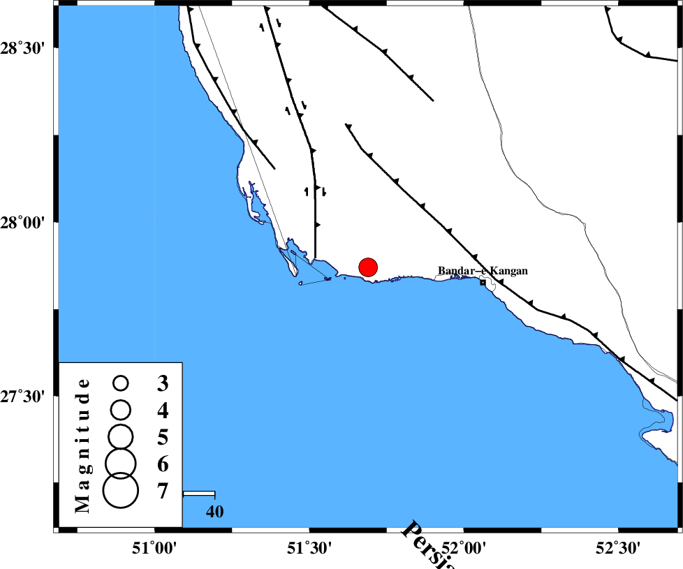
| Location | Lat:27.87 Lon: 51.69 |
| Region | Bushehr Province, 37 km West of Bandar-e kangan |
Nearest Cities |
|
| 24 km South of Abdan, Bushehr Province | |
| 30 km South East of Bardkhun, Bushehr Province | |
| 37 km South East of Abkesh, Bushehr Province | |
| 37 km North West of Bandar-e kangan, Bushehr Province | |
| 42 km South West of Riz, Bushehr Province | |
| Depth | 43 km |
| Agency | |
Faults within 150 km: |
|
| BORAZJAN_F (Length: 168 km) , Distance to epicenter: 17 km | |
| MFF3 (Length: 292 km) , Distance to epicenter: 27 km | |
| ZFF2 (Length: 84 km) , Distance to epicenter: 43 km | |
| Number of Phases | 5 |
| RMS | 0.1 |
| Number of Stations | 4 |
| Error in Latitude | >6.3 km |
| Error in Longitude | 5.5 km |
| Error in Depth | 3 km |
Download waveform in seisan format
to download seisan software Click here
to access information about IIEES stations Click here
Amplitude | ||||||||
| UID | Agency | Station | Component | Amplitude | Period | Arrival Time | Proccessing Time | Signal Clip |
| 82466 | IIEES | AHRM | N | 2859.2 | 0.56 | 2012-03-22 16:39:45 | 2012-03-22 04:02:00 | n |
| 82467 | IIEES | AHRM | E | 3412.8 | 0.88 | 2012-03-22 16:39:47 | 2012-03-22 04:02:00 | n |
| 82468 | IIEES | GHIR | E | 1364.4 | 0.36 | 2012-03-22 16:39:51 | 2012-03-22 04:02:00 | n |
| 82469 | IIEES | GHIR | N | 1025.4 | 0.36 | 2012-03-22 16:39:58 | 2012-03-22 04:02:00 | n |
Phase | ||||||||||||
| Agency | Station | Component | Phase Type | Phase Quality | First Motion | Observed Arrival Time | Time Residual | Loc. Flag | Input Weight | Distance | Azimuth | |
| IIEES | AHRM | Z | Pg | E | 2012-03-22 16:39:28 | 0.02 | y | 117 | 341 | |||
| IIEES | AHRM | N | Sg | E | 2012-03-22 16:39:42 | 0 | y | 117 | 341 | |||
| IIEES | GHIR | Z | Pg | E | 2012-03-22 16:39:30 | -0.02 | y | 135 | 70 | |||
| IIEES | NASN | Z | Pn | E | 2012-03-22 16:40:22 | -0.09 | y | 557 | 11 | |||
| IIEES | TABS | Z | Pn | E | 2012-03-22 16:40:55 | 0.17 | y | 825 | 38 | |||