
Magnitude |
:3.1 |
| Date & Time (UTC) | 2012-03-19 03:03:24.2 |
| Date & Time (Local) | 1390/12/29 06:33:24.2 |
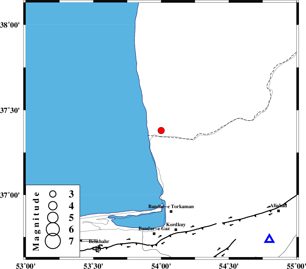
| Location | Lat:37.38 Lon: 54 |
| Region | 54 km North of Bandar-e torkaman |
Nearest Cities |
|
| 32 km North of Gomishtappeh, Golestan Province | |
| 46 km North West of Banavar, Golestan Province | |
| 54 km North of Bandar-e torkaman, Golestan Province | |
| 56 km North West of Sijval, Golestan Province | |
| 57 km North West of Aq Qaleh, Golestan Province | |
| Depth | 14 km |
| Agency | |
Faults within 150 km: |
|
| KHAZAR_F (Length: 523 km) , Distance to epicenter: 66 km | |
| N_ALBORZ_F (Length: 360 km) , Distance to epicenter: 92 km | |
| SHAVAR_F (Length: 87 km) , Distance to epicenter: 97 km | |
| Number of Phases | 7 |
| RMS | 0.1 |
| Number of Stations | 6 |
| Error in Latitude | >4.4 km |
| Error in Longitude | 2.3 km |
| Error in Depth | 5.2 km |
Download waveform in seisan format
to download seisan software Click here
to access information about IIEES stations Click here
Amplitude | ||||||||
| UID | Agency | Station | Component | Amplitude | Period | Arrival Time | Proccessing Time | Signal Clip |
| 82416 | IIEES | THKV | E | 66.9 | 0.68 | 2012-03-19 03:05:05 | 2012-03-19 04:04:00 | n |
Phase | ||||||||||||
| Agency | Station | Component | Phase Type | Phase Quality | First Motion | Observed Arrival Time | Time Residual | Loc. Flag | Input Weight | Distance | Azimuth | |
| IIEES | MRVT | Z | Pn | E | 2012-03-19 03:03:55 | 0.08 | y | 187 | 80 | |||
| IIEES | MRVT | N | Sg | E | 2012-03-19 03:04:17 | -0.1 | y | 187 | 80 | |||
| IIEES | SHRO | Z | Pn | E | 2012-03-19 03:04:01 | 0.08 | y | 235 | 130 | |||
| IIEES | DAMV | Z | Pn | E | 2012-03-19 03:04:05 | -0.15 | y | 266 | 224 | |||
| IIEES | BJRD | Z | Pn | E | 2012-03-19 03:04:09 | 0.03 | y | 303 | 82 | |||
| IIEES | CHTH | Z | Pn | E | 2012-03-19 03:04:10 | 0.07 | y | 305 | 238 | |||
| IIEES | THKV | Z | Pn | E | 2012-03-19 03:04:12 | -0.01 | y | 323 | 241 | |||