
Magnitude |
:3.3 |
| Date & Time (UTC) | 2012-03-14 10:29:10.4 |
| Date & Time (Local) | 1390/12/24 13:59:10.4 |
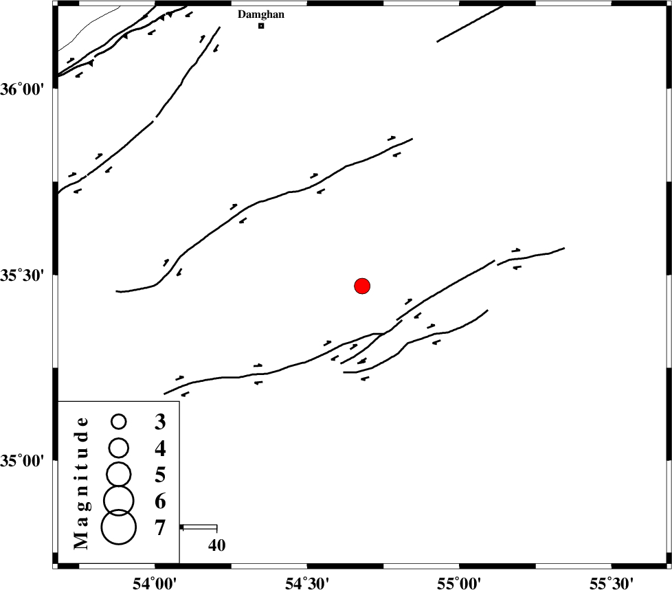
| Location | Lat:35.47 Lon: 54.68 |
| Region | Semnan Province, 83 km South-East of Damghan |
Nearest Cities |
|
| 78 km South East of Amirabad, Semnan Province | |
| 81 km South East of Seydabad, Semnan Province | |
| 83 km South East of Damghan, Semnan Province | |
| 84 km South East of Mehmandust, Semnan Province | |
| 91 km South East of Darvar, Semnan Province | |
| Depth | 14 km |
| Agency | |
Faults within 150 km: |
|
| TORUD_F (Length: 136 km) , Distance to epicenter: 14 km | |
| MEYAMEY_F (Length: 141 km) , Distance to epicenter: 76 km | |
| ATARI_F (Length: 185 km) , Distance to epicenter: 86 km | |
| Number of Phases | 6 |
| RMS | 0.3 |
| Number of Stations | 5 |
| Error in Latitude | >7 km |
| Error in Longitude | 2.9 km |
| Error in Depth | 8.7 km |
Download waveform in seisan format
to download seisan software Click here
to access information about IIEES stations Click here
Amplitude | ||||||||
| UID | Agency | Station | Component | Amplitude | Period | Arrival Time | Proccessing Time | Signal Clip |
| 82349 | IIEES | DAMV | E | 256 | 0.48 | 2012-03-14 10:30:21 | 2012-03-14 09:52:00 | n |
| 82350 | IIEES | GHVR | E | 68.6 | 0.47 | 2012-03-14 10:30:59 | 2012-03-14 09:52:00 | n |
Phase | ||||||||||||
| Agency | Station | Component | Phase Type | Phase Quality | First Motion | Observed Arrival Time | Time Residual | Loc. Flag | Input Weight | Distance | Azimuth | |
| IIEES | SHRO | Z | Pg | E | 2012-03-14 10:29:32 | -0.07 | y | 135 | 63 | |||
| IIEES | DAMV | Z | Pn | E | 2012-03-14 10:29:48 | -0.22 | y | 246 | 275 | |||
| IIEES | CHTH | Z | Pn | E | 2012-03-14 10:29:59 | 0.43 | y | 325 | 280 | |||
| IIEES | CHTH | N | Sg | E | 2012-03-14 10:30:41 | -0.2 | y | 325 | 280 | |||
| IIEES | GHVR | Z | Pn | E | 2012-03-14 10:29:59 | 0.28 | y | 332 | 252 | |||
| IIEES | NASN | Z | Pn | E | 2012-03-14 10:30:00 | -0.19 | y | 343 | 211 | |||