
Magnitude |
:3.4 |
| Date & Time (UTC) | 2012-03-10 17:44:24.8 |
| Date & Time (Local) | 1390/12/20 21:14:24.8 |
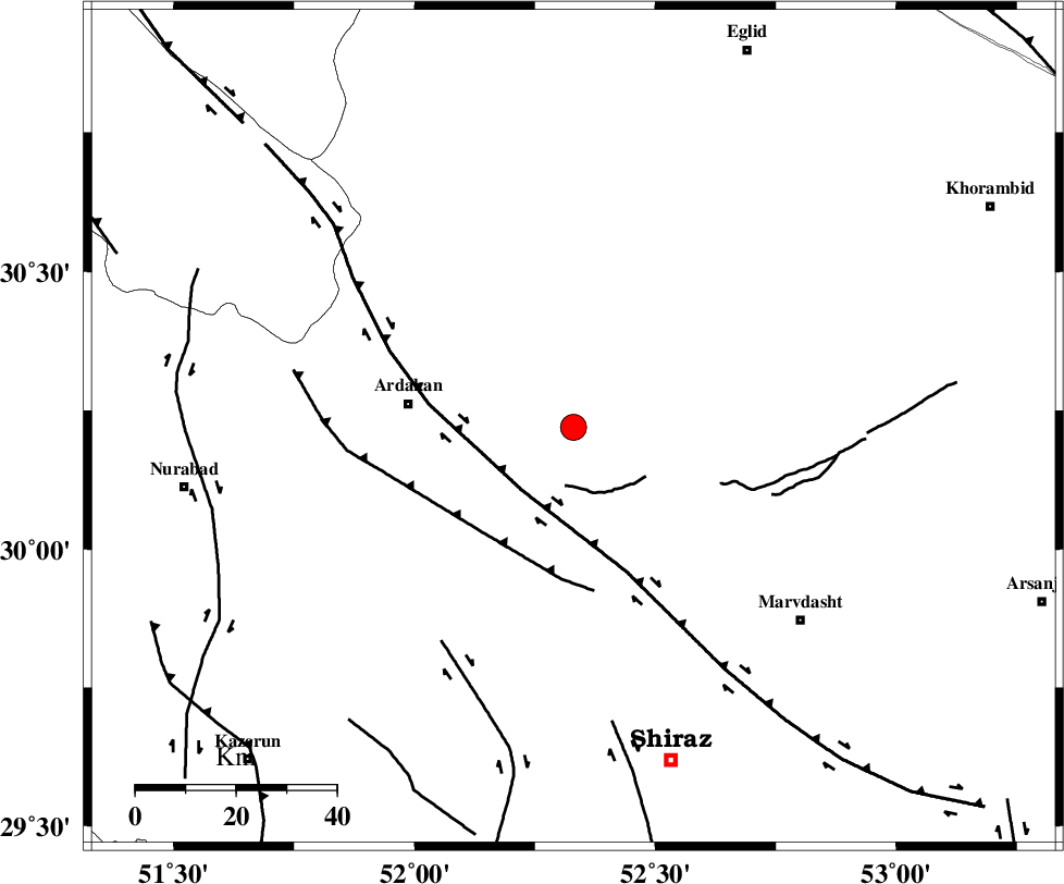
| Location | Lat:30.22 Lon: 52.33 |
| Region | Fars Province, 33 km East of Ardakan |
Nearest Cities |
|
| 9 km North of Dorudzan, Fars Province | |
| 16 km North of Banesh, Fars Province | |
| 21 km South of Bekan, Fars Province | |
| 29 km North West of Bidgol, Fars Province | |
| 30 km North of Baiza, Fars Province | |
| Depth | 14 km |
| Agency | |
Faults within 150 km: |
|
| HZF3 (Length: 197 km) , Distance to epicenter: 16 km | |
| KAREBASS_F (Length: 98 km) , Distance to epicenter: 50 km | |
| SABZ_PUSHAN_F_Z3 (Length: 37 km) , Distance to epicenter: 59 km | |
| Number of Phases | 5 |
| RMS | 0 |
| Number of Stations | 5 |
| Error in Latitude | >1.9 km |
| Error in Longitude | 3.7 km |
| Error in Depth | 7 km |
Download waveform in seisan format
to download seisan software Click here
to access information about IIEES stations Click here
Amplitude | ||||||||
| UID | Agency | Station | Component | Amplitude | Period | Arrival Time | Proccessing Time | Signal Clip |
| 82238 | IIEES | AHRM | E | 384.1 | 0.44 | 2012-03-10 17:45:19 | 2012-03-10 05:47:00 | n |
| 82239 | IIEES | GHIR | N | 251.8 | 0.44 | 2012-03-10 17:45:33 | 2012-03-10 05:47:00 | n |
| 82240 | IIEES | GHIR | E | 336.6 | 0.76 | 2012-03-10 17:45:33 | 2012-03-10 05:47:00 | n |
Phase | ||||||||||||
| Agency | Station | Component | Phase Type | Phase Quality | First Motion | Observed Arrival Time | Time Residual | Loc. Flag | Input Weight | Distance | Azimuth | |
| IIEES | AHRM | Z | Pg | E | 2012-03-10 17:44:54 | -0.04 | y | 180 | 214 | |||
| IIEES | GHIR | Z | Pn | E | 2012-03-10 17:45:00 | 0.05 | y | 224 | 163 | |||
| IIEES | NASN | Z | Pn | E | 2012-03-10 17:45:08 | -0.05 | y | 290 | 9 | |||
| IIEES | KRBR | Z | Pn | E | 2012-03-10 17:45:25 | -0.02 | y | 428 | 92 | |||
| IIEES | KHMZ | Z | Pn | E | 2012-03-10 17:45:28 | 0.07 | y | 450 | 331 | |||