
Magnitude |
:2.8 |
| Date & Time (UTC) | 2012-03-07 21:20:46.1 |
| Date & Time (Local) | 1390/12/18 00:50:46.1 |
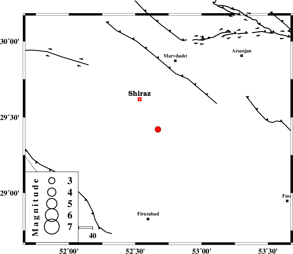
| Location | Lat:29.42 Lon: 52.67 |
| Region | Fars Province, 26 km South-East of Shiraz |
Nearest Cities |
|
| 14 km South of Soltanabad, Fars Province | |
| 17 km North West of Maharlu, Fars Province | |
| 17 km North of Tasuj, Fars Province | |
| 23 km North West of Akbarabad, Fars Province | |
| 26 km North of Kavar, Fars Province | |
| Depth | 14 km |
| Agency | |
Faults within 150 km: |
|
| SABZ_PUSHAN_F_Z1 (Length: 69 km) , Distance to epicenter: 7 km | |
| SABZ_PUSHAN_F_Z3 (Length: 37 km) , Distance to epicenter: 17 km | |
| HZF3 (Length: 197 km) , Distance to epicenter: 31 km | |
| Number of Phases | 7 |
| RMS | 0.1 |
| Number of Stations | 5 |
| Error in Latitude | >3.1 km |
| Error in Longitude | 2 km |
| Error in Depth | 9.2 km |
Download waveform in seisan format
to download seisan software Click here
to access information about IIEES stations Click here
Amplitude | ||||||||
| UID | Agency | Station | Component | Amplitude | Period | Arrival Time | Proccessing Time | Signal Clip |
| 82192 | IIEES | GHIR | N | 226.4 | 0.36 | 2012-03-07 21:21:28 | 2012-03-07 08:46:00 | n |
| 82193 | IIEES | GHIR | E | 278.3 | 0.8 | 2012-03-07 21:21:30 | 2012-03-07 08:46:00 | n |
| 82194 | IIEES | AHRM | N | 132.3 | 0.56 | 2012-03-07 21:21:32 | 2012-03-07 08:46:00 | n |
| 82195 | IIEES | AHRM | E | 109.4 | 0.4 | 2012-03-07 21:21:33 | 2012-03-07 08:46:00 | n |
Phase | ||||||||||||
| Agency | Station | Component | Phase Type | Phase Quality | First Motion | Observed Arrival Time | Time Residual | Loc. Flag | Input Weight | Distance | Azimuth | |
| IIEES | GHIR | Z | Pg | E | 2012-03-07 21:21:07 | -0.07 | y | 130 | 166 | |||
| IIEES | GHIR | E | Sg | E | 2012-03-07 21:21:23 | 0.08 | y | 130 | 166 | |||
| IIEES | AHRM | Z | Pg | E | 2012-03-07 21:21:10 | -0.07 | y | 147 | 246 | |||
| IIEES | AHRM | E | Sg | E | 2012-03-07 21:21:28 | 0.05 | y | 147 | 246 | |||
| IIEES | NASN | Z | Pn | E | 2012-03-07 21:21:40 | 0.1 | y | 375 | 2 | |||
| IIEES | KRBR | Z | Pn | E | 2012-03-07 21:21:43 | -0.05 | y | 401 | 80 | |||
| IIEES | KHMZ | Z | Pn | E | 2012-03-07 21:22:01 | -0.04 | y | 543 | 332 | |||