
Magnitude |
:4.2 |
| Date & Time (UTC) | 2012-03-07 16:57:12.6 |
| Date & Time (Local) | 1390/12/17 20:27:12.6 |
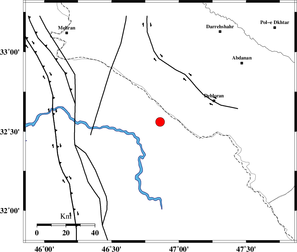
| Location | Lat:32.56 Lon: 46.86 |
| Region | Iraq, 40 km South-West of Dehloran |
Nearest Cities |
|
| 31 km South West of Bishehzar, Ilam Province | |
| 40 km South West of Dehloran, Ilam Province | |
| 47 km North West of Musian, Ilam Province | |
| 70 km South West of Abdanan, Ilam Province | |
| 75 km South of Meymeh, Ilam Province | |
| Depth | 18 km |
| Agency | |
Faults within 150 km: |
|
| MFF6 (Length: 144 km) , Distance to epicenter: 32 km | |
| BALARUD_F_Z1 (Length: 87 km) , Distance to epicenter: 69 km | |
| ZFF4 (Length: 128 km) , Distance to epicenter: 77 km | |
| Number of Phases | 8 |
| RMS | 0.1 |
| Number of Stations | 5 |
| Error in Latitude | >1.9 km |
| Error in Longitude | 3.6 km |
| Error in Depth | 4.2 km |
Download waveform in seisan format
to download seisan software Click here
to access information about IIEES stations Click here
Amplitude | ||||||||
| UID | Agency | Station | Component | Amplitude | Period | Arrival Time | Proccessing Time | Signal Clip |
| 82186 | IIEES | SHGR | E | 3106.1 | 0.32 | 2012-03-07 16:58:13 | 2012-03-07 04:15:00 | n |
| 82187 | IIEES | SHGR | N | 2465.5 | 0.36 | 2012-03-07 16:58:13 | 2012-03-07 04:15:00 | n |
| 82188 | IIEES | SNGE | E | 904.8 | 0.56 | 2012-03-07 16:58:39 | 2012-03-07 04:15:00 | n |
| 82189 | IIEES | SNGE | N | 1135.5 | 0.56 | 2012-03-07 16:58:42 | 2012-03-07 04:15:00 | n |
Phase | ||||||||||||
| Agency | Station | Component | Phase Type | Phase Quality | First Motion | Observed Arrival Time | Time Residual | Loc. Flag | Input Weight | Distance | Azimuth | |
| IIEES | SHGR | Z | P | E | 2012-03-07 16:57:43 | -0.02 | y | 189 | 105 | |||
| IIEES | SHGR | E | Sg | E | 2012-03-07 16:58:06 | 0.08 | y | 189 | 105 | |||
| IIEES | SNGE | Z | Pn | E | 2012-03-07 16:57:55 | 0.12 | y | 285 | 9 | |||
| IIEES | SNGE | E | Sg | E | 2012-03-07 16:58:32 | 0.04 | y | 285 | 9 | |||
| IIEES | ASAO | Z | Pn | E | 2012-03-07 16:58:05 | -0.1 | y | 368 | 52 | |||
| IIEES | ASAO | N | Sg | E | 2012-03-07 16:58:55 | -0.03 | y | 368 | 52 | |||
| IIEES | GHVR | Z | Pn | E | 2012-03-07 16:58:17 | -0.01 | y | 460 | 61 | |||
| IIEES | THKV | Z | P | E | 2012-03-07 16:58:25 | -0.17 | y | 525 | 44 | |||