
Magnitude |
:2.9 |
| Date & Time (UTC) | 2012-02-29 23:06:12.5 |
| Date & Time (Local) | 1390/12/11 02:36:12.5 |
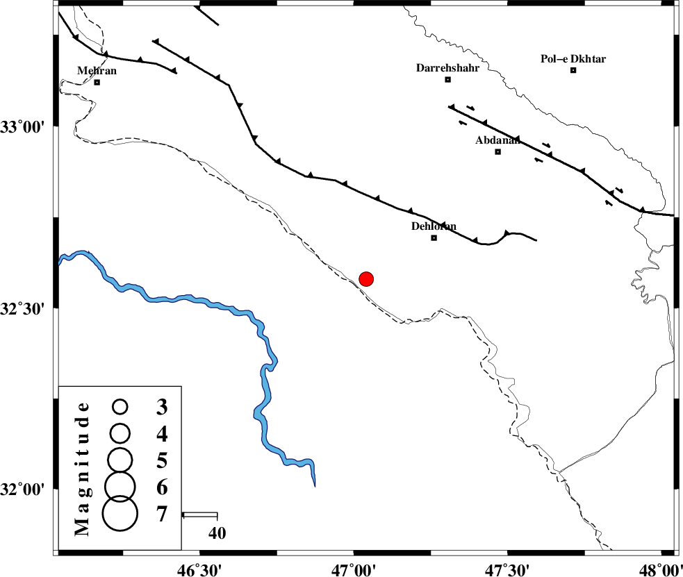
| Location | Lat:32.58 Lon: 47.04 |
| Region | Ilam Province, 24 km South-West of Dehloran |
Nearest Cities |
|
| 24 km South West of Dehloran, Ilam Province | |
| 28 km South of Bishehzar, Ilam Province | |
| 30 km North West of Musian, Ilam Province | |
| 56 km South West of Abdanan, Ilam Province | |
| 61 km South West of Sarabbagh, Ilam Province | |
| Depth | 16 km |
| Agency | |
Faults within 150 km: |
|
| MFF6 (Length: 144 km) , Distance to epicenter: 24 km | |
| BALARUD_F_Z1 (Length: 87 km) , Distance to epicenter: 58 km | |
| ZFF4 (Length: 128 km) , Distance to epicenter: 85 km | |
| Number of Phases | 6 |
| RMS | 0.1 |
| Number of Stations | 4 |
| Error in Latitude | >1.8 km |
| Error in Longitude | 3.8 km |
| Error in Depth | 5.1 km |
Download waveform in seisan format
to download seisan software Click here
to access information about IIEES stations Click here
Amplitude | ||||||||
| UID | Agency | Station | Component | Amplitude | Period | Arrival Time | Proccessing Time | Signal Clip |
| 82108 | IIEES | SHGR | E | 132.9 | 0.4 | 2012-02-29 23:07:07 | 2012-03-01 02:02:00 | n |
Phase | ||||||||||||
| Agency | Station | Component | Phase Type | Phase Quality | First Motion | Observed Arrival Time | Time Residual | Loc. Flag | Input Weight | Distance | Azimuth | |
| IIEES | SHGR | Z | Pg | E | 2012-02-29 23:06:41 | 0.07 | y | 174 | 107 | |||
| IIEES | SHGR | E | Sg | E | 2012-02-29 23:07:02 | -0.08 | y | 174 | 107 | |||
| IIEES | SNGE | Z | Pn | E | 2012-02-29 23:06:54 | -0.1 | y | 280 | 6 | |||
| IIEES | KHMZ | Z | Pn | E | 2012-02-29 23:06:57 | 0.04 | y | 301 | 64 | |||
| IIEES | ASAO | Z | Pn | E | 2012-02-29 23:07:04 | 0.07 | y | 353 | 51 | |||
| IIEES | ASAO | E | Sg | E | 2012-02-29 23:07:51 | 0.01 | y | 353 | 51 | |||