
Magnitude |
:2.8 |
| Date & Time (UTC) | 2012-02-28 23:41:49.1 |
| Date & Time (Local) | 1390/12/10 03:11:49.1 |
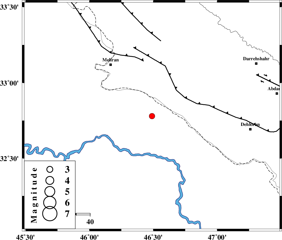
| Location | Lat:32.78 Lon: 46.49 |
| Region | Iraq, 48 km South-East of Mehran |
Nearest Cities |
|
| 46 km West of Bishehzar, Ilam Province | |
| 48 km South East of Mehran, Ilam Province | |
| 52 km South of Gonbad-e pirmohammad, Ilam Province | |
| 62 km South of Galeh-yedarre-hemalakshahi, Ilam Province | |
| 65 km South West of Meymeh, Ilam Province | |
| Depth | 15 km |
| Agency | |
Faults within 150 km: |
|
| MFF6 (Length: 144 km) , Distance to epicenter: 26 km | |
| ZFF4 (Length: 128 km) , Distance to epicenter: 41 km | |
| MFF7 (Length: 99 km) , Distance to epicenter: 56 km | |
| Number of Phases | 4 |
| RMS | 0.1 |
| Number of Stations | 4 |
| Error in Latitude | >5.5 km |
| Error in Longitude | 3.4 km |
| Error in Depth | 0 km |
Download waveform in seisan format
to download seisan software Click here
to access information about IIEES stations Click here
Amplitude | ||||||||
| UID | Agency | Station | Component | Amplitude | Period | Arrival Time | Proccessing Time | Signal Clip |
| 82071 | IIEES | SHGR | E | 72.5 | 0.44 | 2012-02-28 23:43:03 | 2012-02-29 02:53:00 | n |
| 82072 | IIEES | SHGR | N | 84.4 | 0.72 | 2012-02-28 23:43:04 | 2012-02-29 02:53:00 | n |
| 82073 | IIEES | SNGE | E | 37.9 | 0.6 | 2012-02-28 23:43:19 | 2012-02-29 02:53:00 | n |
Phase | ||||||||||||
| Agency | Station | Component | Phase Type | Phase Quality | First Motion | Observed Arrival Time | Time Residual | Loc. Flag | Input Weight | Distance | Azimuth | |
| IIEES | SHGR | Z | Pn | E | 2012-02-28 23:42:25 | 0.03 | y | 230 | 108 | |||
| IIEES | SNGE | Z | Pn | E | 2012-02-28 23:42:30 | -0.02 | y | 268 | 17 | |||
| IIEES | KHMZ | Z | Pn | E | 2012-02-28 23:42:39 | -0.19 | y | 341 | 71 | |||
| IIEES | ASAO | Z | Pn | E | 2012-02-28 23:42:44 | 0.19 | y | 382 | 58 | |||