
Magnitude |
:1.6 |
| Date & Time (UTC) | 2012-02-24 23:44:32.0 |
| Date & Time (Local) | 1390/12/6 03:14:32.0 |
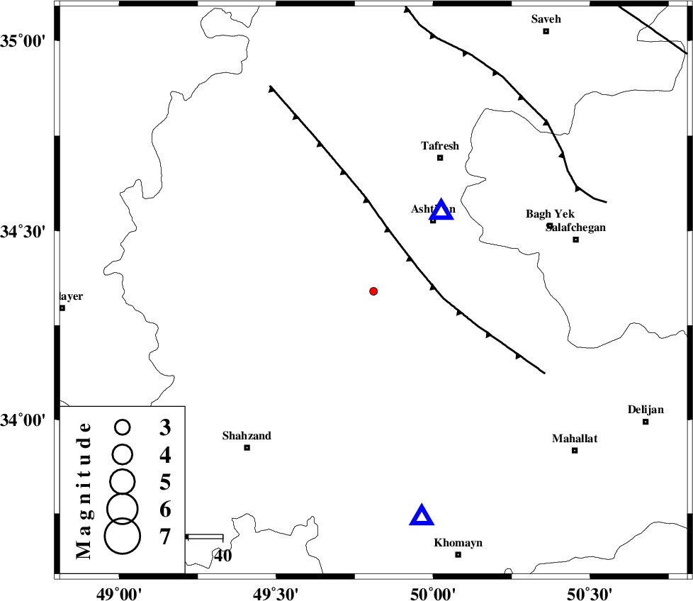
| Location | Lat:34.34 Lon: 49.81 |
| Region | Markazi Province, 30 km North-East of Arak |
Nearest Cities |
|
| 8 km North of Davoodabad, Markazi Province | |
| 13 km North East of Ebakabad, Markazi Province | |
| 22 km South East of Farmahin, Markazi Province | |
| 26 km North West of Ebrahimabad, Markazi Province | |
| 27 km South West of Ashtiyan, Markazi Province | |
| Depth | 14 km |
| Agency | |
Faults within 150 km: |
|
| TAFRESH_F (Length: 117 km) , Distance to epicenter: 15 km | |
| INDES_F (Length: 98 km) , Distance to epicenter: 67 km | |
| KUSHK_E_NOSRAT_F (Length: 230 km) , Distance to epicenter: 101 km | |
| Number of Phases | 7 |
| RMS | 0.1 |
| Number of Stations | 4 |
| Error in Latitude | >1.3 km |
| Error in Longitude | 1.2 km |
| Error in Depth | 8.6 km |
Download waveform in seisan format
to download seisan software Click here
to access information about IIEES stations Click here
Amplitude | ||||||||
| UID | Agency | Station | Component | Amplitude | Period | Arrival Time | Proccessing Time | Signal Clip |
| 81995 | IIEES | KHMZ | N | 27.3 | 0.12 | 2012-02-24 23:44:53 | 2012-02-24 11:27:00 | n |
| 81996 | IIEES | GHVR | E | 13.1 | 0.28 | 2012-02-24 23:45:12 | 2012-02-24 11:27:00 | n |
Phase | ||||||||||||
| Agency | Station | Component | Phase Type | Phase Quality | First Motion | Observed Arrival Time | Time Residual | Loc. Flag | Input Weight | Distance | Azimuth | |
| IIEES | ASAO | Z | Pg | E | 2012-02-24 23:44:38 | 0.11 | y | 30.7 | 41 | |||
| IIEES | ASAO | N | Sg | E | 2012-02-24 23:44:42 | -0.13 | y | 30.7 | 41 | |||
| IIEES | KHMZ | Z | Pg | E | 2012-02-24 23:44:44 | 0.13 | y | 68.2 | 168 | |||
| IIEES | KHMZ | N | Sg | E | 2012-02-24 23:44:52 | -0.16 | y | 68.2 | 168 | |||
| IIEES | GHVR | Z | Pg | E | 2012-02-24 23:44:54 | 0.08 | y | 133 | 83 | |||
| IIEES | GHVR | E | Sg | E | 2012-02-24 23:45:10 | 0.01 | y | 133 | 83 | |||
| IIEES | SNGE | N | Sg | E | 2012-02-24 23:45:40 | -0.03 | y | 240 | 291 | |||