
Magnitude |
:2.8 |
| Date & Time (UTC) | 2012-02-23 15:54:18.0 |
| Date & Time (Local) | 1390/12/4 19:24:18.0 |
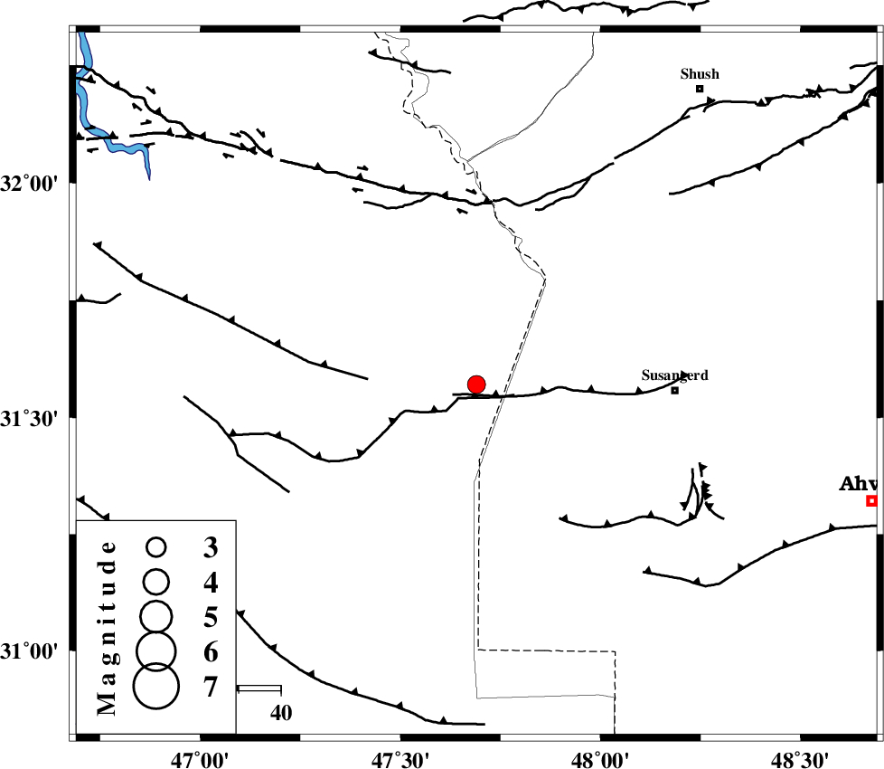
| Location | Lat:31.57 Lon: 47.69 |
| Region | Iraq, 47 km West of Susangerd |
Nearest Cities |
|
| 33 km South West of Bostan, Khoozestan Province | |
| 38 km North West of Hoveizeh, Khoozestan Province | |
| 47 km North West of Susangerd, Khoozestan Province | |
| 55 km North West of Jalaliyeh, Khoozestan Province | |
| 71 km North West of Hamidiyeh, Khoozestan Province | |
| Depth | 41 km |
| Agency | |
Faults within 150 km: |
|
| AHVAZ_F (Length: 99 km) , Distance to epicenter: 48 km | |
| DEZFUL_EMBAYMENT (Length: 228 km) , Distance to epicenter: 123 km | |
| MFF6 (Length: 144 km) , Distance to epicenter: 124 km | |
| Number of Phases | 6 |
| RMS | 0.1 |
| Number of Stations | 4 |
| Error in Latitude | >4 km |
| Error in Longitude | 5.2 km |
| Error in Depth | 4.7 km |
Download waveform in seisan format
to download seisan software Click here
to access information about IIEES stations Click here
Amplitude | ||||||||
| UID | Agency | Station | Component | Amplitude | Period | Arrival Time | Proccessing Time | Signal Clip |
| 81963 | IIEES | SHGR | E | 299.2 | 0.28 | 2012-02-23 15:54:58 | 2012-02-23 04:11:00 | n |
| 81964 | IIEES | SHGR | N | 115.2 | 0.48 | 2012-02-23 15:55:01 | 2012-02-23 04:11:00 | n |
Phase | ||||||||||||
| Agency | Station | Component | Phase Type | Phase Quality | First Motion | Observed Arrival Time | Time Residual | Loc. Flag | Input Weight | Distance | Azimuth | |
| IIEES | SHGR | Z | Pg | E | 2012-02-23 15:54:38 | -0.08 | y | 121 | 60 | |||
| IIEES | SHGR | N | Sg | E | 2012-02-23 15:54:53 | 0.11 | y | 121 | 60 | |||
| IIEES | KHMZ | Z | Pn | E | 2012-02-23 15:55:03 | -0.08 | y | 321 | 41 | |||
| IIEES | KHMZ | N | Sg | E | 2012-02-23 15:55:46 | -0.08 | y | 321 | 41 | |||
| IIEES | SNGE | Z | Pn | E | 2012-02-23 15:55:12 | 0.07 | y | 392 | 355 | |||
| IIEES | ASAO | N | Pn | E | 2012-02-23 15:55:12 | 0.06 | y | 396 | 33 | |||