
Magnitude |
:2.9 |
| Date & Time (UTC) | 2012-02-21 19:44:09.0 |
| Date & Time (Local) | 1390/12/2 23:14:09.0 |
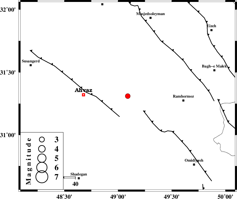
| Location | Lat:31.31 Lon: 49.09 |
| Region | Khoozestan Province, 40 km East of Ahvaz |
Nearest Cities |
|
| 18 km North East of Mashrehat, Khoozestan Province | |
| 28 km South East of Veys, Khoozestan Province | |
| 32 km North West of Marbacheh, Khoozestan Province | |
| 35 km South East of Talieh, Khoozestan Province | |
| 37 km South East of Mollasani, Khoozestan Province | |
| Depth | 23 km |
| Agency | |
Faults within 150 km: |
|
| AGHAJARI_F (Length: 88 km) , Distance to epicenter: 19 km | |
| AHVAZ_F (Length: 99 km) , Distance to epicenter: 20 km | |
| DEZFUL_EMBAYMENT (Length: 228 km) , Distance to epicenter: 57 km | |
| Number of Phases | 5 |
| RMS | 0.3 |
| Number of Stations | 4 |
| Error in Latitude | >10.2 km |
| Error in Longitude | 10.1 km |
| Error in Depth | 9.9 km |
Download waveform in seisan format
to download seisan software Click here
to access information about IIEES stations Click here
Amplitude | ||||||||
| UID | Agency | Station | Component | Amplitude | Period | Arrival Time | Proccessing Time | Signal Clip |
| 81955 | IIEES | SHGR | E | 506.3 | 0.52 | 2012-02-21 19:44:43 | 2012-02-21 07:45:00 | n |
| 81956 | IIEES | SHGR | N | 370.4 | 0.52 | 2012-02-21 19:44:47 | 2012-02-21 07:45:00 | n |
| 81957 | IIEES | SNGE | N | 13.6 | 0.48 | 2012-02-21 19:46:01 | 2012-02-21 07:45:00 | n |
Phase | ||||||||||||
| Agency | Station | Component | Phase Type | Phase Quality | First Motion | Observed Arrival Time | Time Residual | Loc. Flag | Input Weight | Distance | Azimuth | |
| IIEES | SHGR | Z | Pg | E | 2012-02-21 19:44:24 | 0.15 | y | 92.4 | 343 | |||
| IIEES | SHGR | E | Sg | E | 2012-02-21 19:44:35 | -0.15 | y | 92.4 | 343 | |||
| IIEES | KHMZ | Z | Pn | E | 2012-02-21 19:44:51 | 0.4 | y | 281 | 17 | |||
| IIEES | NASN | Z | Pn | E | 2012-02-21 19:45:03 | -0.28 | y | 388 | 64 | |||
| IIEES | SNGE | Z | Pn | E | 2012-02-21 19:45:11 | -0.23 | y | 450 | 339 | |||